Rajakaluve Encroachment Finder
Please use address details from sale deed for correct results
Disclaimer: The information provided on this link is based solely on public data available on the BBMP website. The information has not be modified or altered in any manner and does not contain any opinion or views of IIMB or its Management or employees. Please seek legal opinion to validate this information before you act upon it.
Is your property on a Rajakaluve?
Here is a way to find out. BBMP has notified properties with survey numbers that are encroaching on BBMP website. Our portal makes it easy to access these documents and give a summary view. In addition, we give indication of possible notification from BBMP in future based on documents collected from Land Records Website. Use the drop down menu on the left to select the (taluk, hobli, village) combination for your property. A list of all affected survey numbers will be displayed below with links to relevant documents.
Based on BBMP data provided on: 17th Dec 2016
Colour Legend
---On a Rajakaluve & notified as encroaching---
Your survey has been notified by BBMP for encroachment.
---On a Rajakaluve but not yet notified as encroaching---
Your survey has not been notified by BBMP. However, as per Revenue Department, rajakaluve passes through your survey.
---Near Rajakaluve but status is unclear---
Your survey is mentioned either in the BBMP or Revenue Department documents but it is not clear that you are encroaching.
---Listed as Non-Encroaching---
Your survey number is clearly mentioned as NOT encroaching in BBMP / Revenue Dept. document
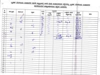
18665 - Chikkakallasandra Village
(Bangalore South Taluk, Uttarahalli 4 Hobli)
ಚಿಕ್ಕಲಸಂದ್ರ ಗ್ರಾಮ
(ಬೆಂಗಳೂರು ದಕ್ಷಿಣ ತಾಲ್ಲೂಕು, ಉತ್ತರಹಳ್ಳಿ ಹೋಬಳಿ)
| Survey Number | Encroaching as per BBMP Notification | Encroaching as per Revenue Dept. | Document Details |
|---|---|---|---|
| 9 | no data | yes | View |
| 17 | no data | yes | View |
| 8 | no data | no | View |
| 10 | no data | no | View |
| 11 | no data | no | View |
| 12 | no data | no | View |
| 13 | no data | no | View |
| 14 | no data | no | View |
| 16 | no data | no | View |
| 33 | no data | no | View |
| All others | no data | Not in the Rajakaluve folder published by Revenue Department | View |
Specific Files
Please click view button in table above to see files here.
Common files for all surveys
in Chikkakallasandra


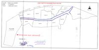
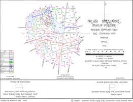
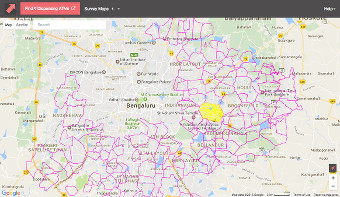
Locate your property on an interactive map by visiting swd.mapshalli.org
Note: By clicking the link above you will be leaving IIMB-RERI portal and visiting a third-party site.
Comments (811)
Mapsalli
23 Apr 2024, 7:47 pmMr Ali (AGENTALY 9538351721) is very Professional and extreme Knowledgeable he provides details of Property Just with location. His service called Pre Property Purchase Analysis was amazing. Will Recommend him check his list below. Looking for Pre Token Guidence Regarding property purchase basically Just by Location. Pre Advance or Pre Purchase Save your Time Money. 1. Colour Zone based on Cdp 2. Village map survey details 3. Rajakaluves 4. Lake Bed 5. Buffer Zone 6. Basic Details on RTC , Mutation, Records 7. History Of Property location 8. Sea Level of Property Search for AGENTALY in YouTube Https://wa.me/919538351721 #legal #bbmp #rajakaluves #bufferzone #lake #lakebed #property #propertyadvise #realesate #advisor
Mapsalli
21 Apr 2024, 9:31 pmMr Ali (AGENTALY 9538351721) is very Professional and extreme Knowledgeable he provides details of Property Just with location. His service called Pre Property Purchase Analysis was amazing. Will Recommend him check his list below. Looking for Pre Token Guidence Regarding property purchase basically Just by Location. Pre Advance or Pre Purchase Save your Time Money. 1. Colour Zone based on Cdp 2. Village map survey details 3. Rajakaluves 4. Lake Bed 5. Buffer Zone 6. Basic Details on RTC , Mutation, Records 7. History Of Property location 8. Sea Level of Property Search for AGENTALY in YouTube Https://wa.me/919538351721 #legal #bbmp #rajakaluves #bufferzone #lake #lakebed #property #propertyadvise #realesate #advisor
RajakaluveAndBufferzone
20 Apr 2024, 3:18 pmHi All, Any property buyers looking for any issues with legal and information on lakes and Rajakaluve and buffer zone is concerned.You can reach us in advance via email or over Call. Visit our Below is our website and post your questions and concerns. https://rajakaluveandbufferzone.in/ Ph : 7349192230 Email : reddy.Santhosh1986@gmail.com Thanks Santhosh K reddy
Kumar
19 Apr 2024, 11:38 pmBda has encroached survey no99 which is tank in kembathalli village. Uttar halli hobli .. Its blocking the rajkaluve rain drain ..
Veeranna
29 Mar 2024, 5:56 pmSumadhura sushantham apartments is it under Raja kalve in Thindlu area
Mapsalli
28 Mar 2024, 9:26 pmMr Ali (AGENTALY 9538351721) is very Professional and extreme Knowledgeable he provides details of Property Just with location. His service called Pre Property Purchase Analysis was amazing. Will Recommend him check his list below. Looking for Pre Token Guidence Regarding property purchase basically Just by Location. Pre Advance or Pre Purchase Save your Time Money. 1. Colour Zone based on Cdp 2. Village map survey details 3. Rajakaluves 4. Lake Bed 5. Buffer Zone 6. Basic Details on RTC , Mutation, Records 7. History Of Property location 8. Sea Level of Property Search for AGENTALY in YouTube Https://wa.me/919538351721 #legal #bbmp #rajakaluves #bufferzone #lake #lakebed #property #propertyadvise #realesate #advisor
Sharmila.R
26 Mar 2024, 4:21 pmWhat is Ejipura 20 c cross survey no please
Santosh
25 Mar 2024, 11:02 pmPlease check and revert me About JJ properties is belongs to rajakaleve or not
Suraj
12 Mar 2024, 12:32 amSurvey number 127/1.Please let me know Rajkaluve passes through this.
Ravi
7 Mar 2024, 11:37 pmCan we buy unconverted plots in green belt (Yamare village, Anekar taluk, Sarjapura 2 Hobli)near Dommasandra cirle and construct a house. survey no 117/2.
Ajayniranjan
3 Mar 2024, 11:27 pmAjay
Mapsalli
1 Mar 2024, 12:00 amMr Ali (AGENTALY 9538351721) is very Professional and extreme Knowledgeable he provides details of Property Just with location. His service called Pre Property Purchase Analysis was amazing. Will Recommend him check his list below. Looking for Pre Token Guidence Regarding property purchase basically Just by Location. Pre Advance or Pre Purchase Save your Time Money. 1. Colour Zone based on Cdp 2. Village map survey details 3. Rajakaluves 4. Lake Bed 5. Buffer Zone 6. Basic Details on RTC , Mutation, Records 7. History Of Property location 8. Sea Level of Property Search for AGENTALY in YouTube Https://wa.me/919538351721 #legal #bbmp #rajakaluves #bufferzone #lake #lakebed #property #propertyadvise #realesate #advisor
sumitra
29 Feb 2024, 10:09 amSurvey no. 6 in yelenahalli. Please confirm whether rajakaluve passes through it?
Ajay
15 Feb 2024, 9:30 pmHi, Was interested in investing in a property in Judicial layout which comes under survey number 79 and 72 in Allasandra. Can you please help me know if its clear of enroachments
Mahesh Babu
15 Feb 2024, 8:23 pmNo use for this maps how to complete Raja kalvya acupation some people make violation who is responsible right person in BBMP
Ankit
12 Feb 2024, 11:49 pmI found Shiva Teja layout plots in honnenhalli village. Can someone guide on this ?
Ramaswamy iyer
12 Feb 2024, 12:35 pmI recommend Mr Ali I had Refered 3 advocates but I found no issues but Mr Ali identified builder mistakes who occupaid gov land I am so happy I was saved I paid Ali sir extra to save me from my life savings
Sunil Reddy
12 Feb 2024, 12:32 pmPre property token analysis best by Ali sir I will use Mr Ali AGENTALY Pre Purchase Analysis Please Share to all your Loved once his Analysis is Life Saver Not only Rajakaluve He is Masters in Real Estate guide Best person Met in Life.
Mapsalli
12 Feb 2024, 12:30 pmMr Ali (AGENTALY 9538351721) is very Professional and extreme Knowledgeable he provides details of Property Just with location. His service called Pre Property Purchase Analysis was amazing. Will Recommend him check his list below. Looking for Pre Token Guidence Regarding property purchase basically Just by Location. Pre Advance or Pre Purchase Save your Time Money. 1. Colour Zone based on Cdp 2. Village map survey details 3. Rajakaluves 4. Lake Bed 5. Buffer Zone 6. Basic Details on RTC , Mutation, Records 7. History Of Property location 8. Sea Level of Property Search for AGENTALY in YouTube Https://wa.me/919538351721 #legal #bbmp #rajakaluves #bufferzone #lake #lakebed #property #propertyadvise #realesate #advisor
Mallikarjun N
12 Feb 2024, 11:28 amI was fortunate in finding Santhosh K Reddy on the site https://rajakaluveandbufferzone.in. Santhosh K Reddy can provide complete analysis of the property just by the whatsup current location I sent. He does thorough analysis of the property on buffer zones and provides analysis report with proper explanation. During one-one-one conversation, he provided complete walkthrough of the survey maps, CDP Plan, BBMP maps etc. and how the property is compliant w.r.t to the mentioned govt documents. It was such a relief and peace of mind when all my doubts were clarified. I certainly would recommend Santhosh K Reddy to seek his services and expert advice when one wants to buy any property in Bangalore.
Vinayak Deshpande
8 Feb 2024, 7:15 pmHi, Wanted to know about Rajakaluve near Vakil Garden City. I have shortlisted a couple of sites that are at the edge of the property so wanted to know complete details.
Kavitha M gowda
2 Feb 2024, 11:50 amI have planned before any property token I will use Mr Ali AGENTALY Pre Purchase Analysis Please Share to all your Loved once his Analysis is Life Saver Not only Rajakaluve He is Masters in Real Estate guide Best person Met in Life.
Ramaswamy
2 Feb 2024, 11:46 amI have never seen Analysis like Mr Ali I recommend heartly
Mapalli
2 Feb 2024, 11:44 amMr Ali (AGENTALY 9538351721) is very Professional and extreme Knowledgeable he provides details of Property Just with location. His service called Pre Property Purchase Analysis was amazing. Will Recommend him check his list below. Looking for Pre Token Guidence Regarding property purchase basically Just by Location. Pre Advance or Pre Purchase Save your Time Money. 1. Colour Zone based on Cdp 2. Village map survey details 3. Rajakaluves 4. Lake Bed 5. Buffer Zone 6. Basic Details on RTC , Mutation, Records 7. History Of Property location 8. Sea Level of Property Search for AGENTALY in YouTube Https://wa.me/919538351721 #legal #bbmp #rajakaluves #bufferzone #lake #lakebed #property #propertyadvise #realesate #advisor
Mapsalli
2 Feb 2024, 11:43 amMr Ali (AGENTALY 9538351721) is very Professional and extreme Knowledgeable he provides details of Property Just with location. His service called Pre Property Purchase Analysis was amazing. Will Recommend him check his list below. Looking for Pre Token Guidence Regarding property purchase basically Just by Location. Pre Advance or Pre Purchase Save your Time Money. 1. Colour Zone based on Cdp 2. Village map survey details 3. Rajakaluves 4. Lake Bed 5. Buffer Zone 6. Basic Details on RTC , Mutation, Records 7. History Of Property location 8. Sea Level of Property Search for AGENTALY in YouTube Https://wa.me/919538351721 #legal #bbmp #rajakaluves #bufferzone #lake #lakebed #property #propertyadvise #realesate #advisor
Aswath Kumar
30 Jan 2024, 10:43 pmI highly recommend to contact Mr. SANTHOSH for any rajakaluve queries , his knowledge about rajakaluve is immense . I had lot of queries about few of the properties which i was planning to purchase , all of my queries were properly addressed through video call . He provides complete explanation with all the supporting documents and facts by which I was able to decide whether to go with purchase or not . His Contact details - reddy.santhosh1986@gmail.com
Mamta
28 Jan 2024, 9:35 pmPlease can you help - I have a plot in Reliaable woods layout, 4th A Main, 8th Cross. Would like to know if this comes under Raj Kaluwa as I have been told because I would like to construct a house.
https://rajakaluveandbufferzone.in/
19 Jan 2024, 7:14 pmPost your rajakaluve AND BUFFER ZONE quires and concerns with basic details like property name and your contact number to the above website we will get back to ASAP. Thanks, SANTHOSH K REDDY
Mapsalli
19 Jan 2024, 4:44 pmMr Ali (AGENTALY 9538351721) is very Professional and extreme Knowledgeable he provides details of Property Just with location. His service called Pre Property Purchase Analysis was amazing. Will Recommend him check his list below. Looking for Pre Token Guidence Regarding property purchase basically Just by Location. Pre Advance or Pre Purchase Save your Time Money. 1. Colour Zone based on Cdp 2. Village map survey details 3. Rajakaluves 4. Lake Bed 5. Buffer Zone 6. Basic Details on RTC , Mutation, Records 7. History Of Property location 8. Sea Level of Property Search for AGENTALY in YouTube Https://wa.me/919538351721 #legal #bbmp #rajakaluves #bufferzone #lake #lakebed #property #propertyadvise #realesate #advisor
Lakshmikanth
17 Jan 2024, 9:25 pmWhy there is no survey done for survey number 19 in basavanapura village beguru 3 hobli. Kindly let me know the details
LIKITH D
17 Jan 2024, 9:14 amPlease Provide Kammanahalli KMZ file
https://rajakaluveandbufferzone.in/
7 Jan 2024, 4:01 pmPost your queries and questions on below website.We will get back to shortly. https://rajakaluveandbufferzone.in/
Sandy
6 Jan 2024, 10:42 amWhat is Lake & Nala buffer in Bangalore ?
Mapsalli
1 Jan 2024, 2:56 pmMr Ali (AGENTALY 9538351721) is very Professional and extreme Knowledgeable he provides details of Property Just with location. His service called Pre Property Purchase Analysis was amazing. Will Recommend him check his list below. Looking for Pre Token Guidence Regarding property purchase basically Just by Location. Pre Advance or Pre Purchase Save your Time Money. 1. Colour Zone based on Cdp 2. Village map survey details 3. Rajakaluves 4. Lake Bed 5. Buffer Zone 6. Basic Details on RTC , Mutation, Records 7. History Of Property location 8. Sea Level of Property Search for AGENTALY in YouTube Https://wa.me/919538351721 #legal #bbmp #rajakaluves #bufferzone #lake #lakebed #property #propertyadvise #realesate #advisor
Shruttika
31 Dec 2023, 1:03 pmOur property site is 30*40 dimension,approved by BDA is on rajakaluve. What next? We are unable to sell the property. What should we do now? We never knew this rajakaluve concept when we bought the property. How should we sell the property now?
Karthikeyan Mohan
29 Dec 2023, 6:02 pmHello ALl, I don't see an option to check the details of Halasuru-Bengaluru-560008. Central Bengaluru option is missing under Taluk drop down.
Praveen
25 Dec 2023, 9:52 pmKithanuru which survey no Rajakaluve map required sir
Suresh
24 Dec 2023, 1:11 pmI have old 900 sft. ancestral property at Ulsoor. The property is 15 feet away from the Strom water drainage.I have decided to demolish and reconstruct a house.My neighbours have built their houses close to the drain. But,I am not interested to encroach the land, and build my house leaving the 15 feet open land as it is. I was told that:- 1.The BBMP will not sanction plan to this old house to demolish and reconstruct. 2. That no plan sanction is required for plots measuring less than 1200 sft! 3.I have to apply for renovation plan and rebuild. 4. First, I have to take permission to demolish existing structure.
https://rajakaluveandbufferzone.in/
23 Dec 2023, 3:52 pm1. Visit the website https://rajakaluveandbufferzone.in This website allows you to post your queries and concerns regarding Rajakaluve encroachment and provides information on specific survey numbers for house, Villa ,Apartment and site or flat in Bangalore.
Kiran
21 Dec 2023, 7:14 amMy village is Chudasandra survey no 52 which I’m currently stated I want to confirm that in this survey number Rajakaluve will go or not please confirm
https://rajakaluveandbufferzone.in/
16 Dec 2023, 7:00 pmPost Your queries and concerns on below and call us directly for required information. https://rajakaluveandbufferzone.in/
Gowri
13 Dec 2023, 10:49 pmSir surgery no. 38.34 . 37 in kothihosalli village yelanka addional 3 zone has rajakaluve
Mapsalli
13 Dec 2023, 9:13 pmMr Ali (AGENTALY 9538351721) is very Professional and extreme Knowledgeable he provides details of Property Just with location. His service called Pre Property Purchase Analysis was amazing. Will Recommend him check his list below. Looking for Pre Token Guidence Regarding property purchase basically Just by Location. Pre Advance or Pre Purchase Save your Time Money. 1. Colour Zone based on Cdp 2. Village map survey details 3. Rajakaluves 4. Lake Bed 5. Buffer Zone 6. Basic Details on RTC , Mutation, Records 7. History Of Property location 8. Sea Level of Property Search for AGENTALY in YouTube Https://wa.me/919538351721 #legal #bbmp #rajakaluves #bufferzone #lake #lakebed #property #propertyadvise #realesate #advisor
SANTHOSH K REDDY
13 Dec 2023, 12:57 pmHi All, Kindly post your queries and concerns. On below Website.We will get back to ASAP. https://rajakaluveandbufferzone.in/
raj
12 Dec 2023, 1:06 pmare buffer zone measured from center or edge of primary rajkaluve ?
Vilas Desai
12 Dec 2023, 12:41 pmI am looking for a surveyor, preferable authorized by Revenue deptt or BBMP to make a study on existence of Raj Kaluve at Surabhi Layout, Shivanahalli, Yelahanka Bangalore 560064. Please contact me on 7349358630. Thanks
Mapsalli
9 Dec 2023, 2:45 pmMr Ali (AGENTALY 9538351721) is very Professional and extreme Knowledgeable he provides details of Property Just with location. His service called Pre Property Purchase Analysis was amazing. Will Recommend him check his list below. Looking for Pre Token Guidence Regarding property purchase basically Just by Location. Pre Advance or Pre Purchase Save your Time Money. 1. Colour Zone based on Cdp 2. Village map survey details 3. Rajakaluves 4. Lake Bed 5. Buffer Zone 6. Basic Details on RTC , Mutation, Records 7. History Of Property location 8. Sea Level of Property Search for AGENTALY in YouTube Https://wa.me/919538351721 #legal #bbmp #rajakaluves #bufferzone #lake #lakebed #property #propertyadvise #realesate #advisor
Thippeswamy
8 Dec 2023, 7:39 pmif you are in doubt then take help of Santhosh where he do very good analysis and suggests go or no go. He provides documents explains over the audio and video call. Thank you Santosh for your assistance and help. SANTHOSH CONTACT NUMBER +91 73491 92230
Santhosh K REDDY
8 Dec 2023, 9:06 amHi Raghavendra and B.A Sunitha , I AM CHECKING ON YOU CASE AND I WILL GET BACK TO YOU WITH DETAILED ANALYSIS SOON . Thanks, Santhosh K Reddy 7349192230
Raghavendra
7 Dec 2023, 8:40 pmAny rajakaluve electronic City phase 2 silicon town near Bhavani industries and tech mahindra
Mapsalli
6 Dec 2023, 9:09 amMr Ali (AGENTALY 9538351721) is very Professional and extreme Knowledgeable he provides details of Property Just with location. His service called Pre Property Purchase Analysis was amazing. Will Recommend him check his list below. Looking for Pre Token Guidence Regarding property purchase basically Just by Location. Pre Advance or Pre Purchase Save your Time Money. 1. Colour Zone based on Cdp 2. Village map survey details 3. Rajakaluves 4. Lake Bed 5. Buffer Zone 6. Basic Details on RTC , Mutation, Records 7. History Of Property location 8. Sea Level of Property Search for AGENTALY in YouTube Https://wa.me/919538351721 #legal #bbmp #rajakaluves #bufferzone #lake #lakebed #property #propertyadvise #realesate #advisor
SANTHOSH K REDDY
3 Dec 2023, 10:37 amHi Dear Frinds, IMP->***This web site not be available for public USE last week of December( 17TH dec to 31st December), due to server maintenance and renew of Licence Certificate. Thanks, Santhosh K Reddy 7349192230
B A Sunitha
2 Dec 2023, 10:37 amBDAsite no.60 has encroached on the storm water drain land and also damaged it's wall. Please send the official in charge to look into it and take necessary steps
Mapsalli
27 Nov 2023, 8:28 pmMr Ali (AGENTALY 9538351721) is very Professional and extreme Knowledgeable he provides details of Property Just with location. His service called Pre Property Purchase Analysis was amazing. Will Recommend him check his list below. Looking for Pre Token Guidence Regarding property purchase basically Just by Location. Pre Advance or Pre Purchase Save your Time Money. 1. Colour Zone based on Cdp 2. Village map survey details 3. Rajakaluves 4. Lake Bed 5. Buffer Zone 6. Basic Details on RTC , Mutation, Records 7. History Of Property location 8. Sea Level of Property Search for AGENTALY in YouTube Https://wa.me/919538351721 #legal #bbmp #rajakaluves #bufferzone #lake #lakebed #property #propertyadvise #realesate #advisor
Sudesh K
27 Nov 2023, 3:40 pmHi, Thanks for the IIMB initiative. I planned to buy the Mantri Serenity Kanakapura Road. https://www.thehindu.com/news/cities/bangalore/hc-asks-bbmp-bda-to-verify-allegations-of-encroachment-of-swds/article28213885.ece Is this resolved? Thanks. We can connect over phone also
SANTHOSH K REDDY
25 Nov 2023, 1:40 pmHI All, ANY NEW PROPERTY BUYERS, WHO NEEDS ANALYSIS AND LEGAL ADVICE ON PROPERTY WHICH YOUR PLANING TO BUY. KINDLY POST YOUR QUIRES AND CONCERNS AND DETAILS OF YOUR PROPERTY TO MY EMAIL ID OR YOU CAN DIRECTLY OVER MY NUMBER. Thanks, Santhosh K Reddy PH :7349192230 REDDY.SANTHOSH1986@GMAIL.COM
lokesh m kankolli
24 Nov 2023, 9:01 amTeam,Do let us know is there any Rajakaluve passes or any land encroachment at survey number 63 of Kengeri/Hemmigepura Ward or not.
Rahman
23 Nov 2023, 5:10 pmplease check survey number: 9/3C (sampiegahalli)
Sidharth R
23 Nov 2023, 11:23 am95 survey number please check
karthik
21 Nov 2023, 5:32 pmSir could you check Survey number 139
Faheem
20 Nov 2023, 10:52 amHi, I am planning to buy house in doddabamsandra (survey no 43 ) but it's very near to rajakalve, pls advice.
Mapsalli
14 Nov 2023, 4:59 pmMr Ali (AGENTALY 9538351721) is very Professional and extreme Knowledgeable he provides details of Property Just with location. His service called Pre Property Purchase Analysis was amazing. Will Recommend him check his list below. Looking for Pre Token Guidence Regarding property purchase basically Just by Location. Pre Advance or Pre Purchase Save your Time Money. 1. Colour Zone based on Cdp 2. Village map survey details 3. Rajakaluves 4. Lake Bed 5. Buffer Zone 6. Basic Details on RTC , Mutation, Records 7. History Of Property location 8. Sea Level of Property Search for AGENTALY in YouTube Https://wa.me/919538351721 #legal #bbmp #rajakaluves #bufferzone #lake #lakebed #property #propertyadvise #realesate #advisor
KUMAR H M
10 Nov 2023, 6:48 ami want to know details of sy.no.14 of white field village? is there raja kaluve in this number?
jagadeesh kr
6 Nov 2023, 2:40 pmI have planning to purchase a house in survey no. 29 at abbigere its slightly connected to rajakaluve in dishank app and also i checked in BBMP rajakaluve.org.in its showing in map but in brief description this survey number is not showing kindly confirm can i purchase or not your valuable required is higly appriciable Thanks & Regards jagadeesh KR
Ganesh
4 Nov 2023, 10:00 pmFor swd buffer zone , do we need to leave 25 meter from the edge of the drain or center of the drain?
Mapsalli
31 Oct 2023, 2:08 pmMr Ali (AGENTALY 9538351721) is very Professional and extreme Knowledgeable he provides details of Property Just with location. His service called Pre Property Purchase Analysis was amazing. Will Recommend him check his list below. Looking for Pre Token Guidence Regarding property purchase basically Just by Location. Pre Advance or Pre Purchase Save your Time Money. 1. Colour Zone based on Cdp 2. Village map survey details 3. Rajakaluves 4. Lake Bed 5. Buffer Zone 6. Basic Details on RTC , Mutation, Records 7. History Of Property location 8. Sea Level of Property Search for AGENTALY in YouTube Https://wa.me/919538351721 #legal #bbmp #rajakaluves #bufferzone #lake #lakebed #property #propertyadvise #realesate #advisor
Koushik
29 Oct 2023, 8:43 pmI would like to thank Santhosh Kondareddy Sir for providing all the insights into Rajakaluve, Buffer zone, BDA and NGT rules and regulations. I was able to get my property evaluated from him and service was truly 100% professional. I recommend everybody who is buying any property in Bangalore to avail this service before registering the property.
Rosi Reddy
28 Oct 2023, 8:11 pmThank you very much santhosh Reddy sir. I am very much relieved after you clarified my doubts.Your precise explanation was awesome.Once again thank you very much for your service.
Mapsalli
27 Oct 2023, 11:32 pmMr Ali (AGENTALY 9538351721) is very Professional and extreme Knowledgeable he provides details of Property Just with location. His service called Pre Property Purchase Analysis was amazing. Will Recommend him check his list below. Looking for Pre Token Guidence Regarding property purchase basically Just by Location. Pre Advance or Pre Purchase Save your Time Money. 1. Colour Zone based on Cdp 2. Village map survey details 3. Rajakaluves 4. Lake Bed 5. Buffer Zone 6. Basic Details on RTC , Mutation, Records 7. History Of Property location 8. Sea Level of Property Search for AGENTALY in YouTube Https://wa.me/919538351721 #legal #bbmp #rajakaluves #bufferzone #lake #lakebed #property #propertyadvise #realesate #advisor
Asif
27 Oct 2023, 11:17 pmHow much is the lake buffer zone and from where to measure lake buffer zone? Our site located in Thirumenahalli sy no 105
P Gopala Shastry
27 Oct 2023, 5:33 pmಬೆಂಗಳೂರು ದಕ್ಷಿಣ ತಾಲೂಕು,ಕೆಂಗೇರಿ ಹೋಬಳಿಯ, ದೀವಟಿಗೆ ರಆಮನಹಳ್ಳಇ,ಯು ಯಫ್.ಸಿ.ಐ.ಲೇ ಔಟ್ ನಲ್ಲಿ,ರಾಜಕಾಲುವೆ,ಯಾ,ಕೆರೆ,ಯಾ ಬೆಂಗಳೂರು ಅಭಿವೃದ್ಧಿ ಪ್ರಾಧಿಕಾರದ ಭೂಮಿ ಒತ್ತುವರಿ ಆಗಿದೆಯೇ ಎಂದು ಪರೀಕ್ಷಿಸಿ ತಿಳಿಸಿರಿ
Yaminireddy
27 Oct 2023, 1:52 pmMy syno 63/1A please check the rajakaluva in surrounding
Yaminireddy
27 Oct 2023, 1:46 pmMy syno 63/A please check the rajakaluve in surrounding
Venkatesh
25 Oct 2023, 6:15 pmSuper service
Naresh Kumar K S
25 Oct 2023, 1:03 pmI have made a enquiry for Rajakaluve Storm Water Drain Buffer Zone for the bangalore East Kasavanahalli syno-33. I found Santhosh K Reddy Details from JUST Dia. I happy with services and answered all my queries. Thanks, Naresh Kumar
Kiran
16 Oct 2023, 8:48 pmHi, Are these buffer zone rules(50m, 25m, 15m) applicable in BIAAPA area also?
Mapsalli
16 Oct 2023, 10:24 amMr Ali (AGENTALY 9538351721) is very Professional and extreme Knowledgeable he provides details of Property Just with location. His service called Pre Property Purchase Analysis was amazing. Will Recommend him check his list below. Looking for Pre Token Guidence Regarding property purchase basically Just by Location. Pre Advance or Pre Purchase Save your Time Money. 1. Colour Zone based on Cdp 2. Village map survey details 3. Rajakaluves 4. Lake Bed 5. Buffer Zone 6. Basic Details on RTC , Mutation, Records 7. History Of Property location 8. Sea Level of Property Search for AGENTALY in YouTube Https://wa.me/919538351721 #legal #bbmp #rajakaluves #bufferzone #lake #lakebed #property #propertyadvise #realesate #advisor
Chandana
6 Oct 2023, 2:47 pmArasappa layout sayi garden Raja kaluve details plz tell me
Up 71राजा blocks
3 Oct 2023, 2:41 pmनाइस
Ashwath
1 Oct 2023, 9:20 pmHow to re survey rajakaluve
Ashwath
1 Oct 2023, 9:13 pmSidedahalli Sur no17/4 yeshvanthpura hoble please clarify rajakaluve
Marenhalli
20 Sep 2023, 11:31 pmThe property is in jala hobli bangalore north urban katha no200 jala hobli property no.200 jalahalli
Vinay
12 Sep 2023, 10:11 pmHi All, For one of the property at Kengeri where Primary drain vrishabavathi is situated, I booked plot over here in one of layout. I contacted Mr Santhosh k Reddy sir regarding legal opinion for site location. He has explained me thoroughly along with documents. It helped me to understand completely about rules and regulations. Now I have clear picture of what I am buying. Please contact Mr Santhosh for any of your legal opinions. 7349192230, reddy.santhosh1986@gmail.com
Shweta
5 Sep 2023, 4:33 pmHas anyone taken flat in abhigna misty woods, j p nagar 6th phase? any info on raja kaluve near the apartment? please comment
Anoop
4 Sep 2023, 8:28 amNala buffer zone drive way and amenities are allowed???
Divakara
31 Aug 2023, 7:19 pmBangalore south taluk,Begur hobli ,Nyanappanahalli,survey Number 36/2 ,Suraksha Golden Palm Apartments comes under Rajakaluve.Kindly clarify.
Raul
29 Aug 2023, 5:17 pmDoes Skylark Arcadia phase 2 any enrichment too?
Usha Rani
22 Aug 2023, 2:53 pmSomeone please Mr Ali (AGENTALY 9538351721) pretty desperate
Mapsalli
9 Aug 2023, 2:37 pmMr Ali (AGENTALY 9538351721) is very Professional and extreme Knowledgeable he provides details of Property Just with location. His service called Pre Property Purchase Analysis was amazing. Will Recommend him check his list below. Looking for Pre Token Guidence Regarding property purchase basically Just by Location. Pre Advance or Pre Purchase Save your Time Money. 1. Colour Zone based on Cdp 2. Village map survey details 3. Rajakaluves 4. Lake Bed 5. Buffer Zone 6. Basic Details on RTC , Mutation, Records 7. History Of Property location 8. Sea Level of Property Search for AGENTALY in YouTube Https://wa.me/919538351721 #legal #bbmp #rajakaluves #bufferzone #lake #lakebed #property #propertyadvise #realesate #advisor
Hemant Chigadani
9 Aug 2023, 1:27 pmWe were looking for apartment for quite few months with no luck. And then when you find an apartment that perfectly suits you, you get Rajakaluve/SWD/Naala scriness. I have approached Santhosh Kondareddy and he has been very supportive. Does good detailed analysis of the Rajakaluvee/SWD/Naala with supportive documents. I highly recommend him if you are looking for a good surveyor, thanks reddy.santhosh1986@gmail.com and +91 73491 92230
Manjunatha
9 Aug 2023, 12:45 pmHi, I got verified one property which I am planning to buy with lawyer Santosh reddy sir, he explained every minute details neatly with patience. All our doubts get clarified after our discussion with the lawyer. I recommend Santosh sir for all your raja kaluve related questions and documents verification reddy.santhosh1986@gmail.com +91 73491 92230
Mapsalli
2 Aug 2023, 8:45 pmMr Ali (AGENTALY 9538351721) is very Professional and extreme Knowledgeable he provides details of Property Just with location. His service called Pre Property Purchase Analysis was amazing. Will Recommend him check his list below. Looking for Pre Token Guidence Regarding property purchase basically Just by Location. Pre Advance or Pre Purchase Save your Time Money. 1. Colour Zone based on Cdp 2. Village map survey details 3. Rajakaluves 4. Lake Bed 5. Buffer Zone 6. Basic Details on RTC , Mutation, Records 7. History Of Property location 8. Sea Level of Property Search for AGENTALY in YouTube Https://wa.me/919538351721 #legal #bbmp #rajakaluves #bufferzone #lake #lakebed #property #propertyadvise #realesate #advisor
Abhishek Srivastava
2 Aug 2023, 4:03 pmDear Team, please let me know if there is any Rajakaluve near Seegehalli, near to upcoming Prestige Grove project.
Shyam Mohan
1 Aug 2023, 9:24 pmHi Please let me know if my property / flat listed in survey no 335/2 falls under rajakalve encroachment.
Musthaffa
1 Aug 2023, 9:22 pmMathikere m.r jayarama colony
shyam mohan
1 Aug 2023, 8:43 pmI dont see the property with survey no 335/2. an you please confirm
Krishna murthy
30 Jul 2023, 9:35 pmV good
Shruti
29 Jul 2023, 10:52 pmFor 104 it's says encroachment yes for revenue dept and no data for BBMP. Planning to invest in Meda heights property with survey number 104/1B , 104/4 , 104/6, 104/7. Is it safe to invest ?
Jay
19 Jul 2023, 3:03 pmDoes Rajakaluve rules apply to old houses too, built around 2012?
Mukesh
19 Jul 2023, 12:56 pmSurvey No. 163 is not in the entire list. Any idea on why? Or anyone know the status?
Mapsalli
6 Jul 2023, 11:57 amMr Ali (AGENTALY 9538351721) is very Professional and extreme Knowledgeable he provides details of Property Just with location. His service called Pre Property Purchase Analysis was amazing. Will Recommend him check his list below. Looking for Pre Token Guidence Regarding property purchase basically Just by Location. Pre Advance or Pre Purchase Save your Time Money. 1. Colour Zone based on Cdp 2. Village map survey details 3. Rajakaluves 4. Lake Bed 5. Buffer Zone 6. Basic Details on RTC , Mutation, Records 7. History Of Property location 8. Sea Level of Property Search for AGENTALY in YouTube Https://wa.me/919538351721 #legal #bbmp #rajakaluves #bufferzone #lake #lakebed #property #propertyadvise #realesate #advisor
Sati
3 Jul 2023, 2:11 pmWant to know if The valley by Essem 18 falls under Rajakaluve. They are saying that kaluve has shifted the path and there by they are showing the kaaluve outside the layout.
SANTHOSH K REDDY
2 Jul 2023, 3:53 pmHI ALL, FYI..MOST OF THE SURVEY NUMBER IN BANGALORE THERE ARE RAJAKALUVES OR SWD are passing,BUT NOT ALL THE SURVEY ARE ENCROACHED. since may property buyer having confusion and quires and fear in investing many especially in Bangalore after last year floods and demolitions by Government(BBMP) Any question or quires or help. YOU CAN ALWAYS reach me over call or an email. Santhosh k reddy 7349192230 reddy.santhosh1986@gmail.com
Anant Tandon
1 Jul 2023, 1:08 pmArea surrounding Chikkabanahalli lake; Taluk: Bidarahalli1. Survey 34. Encroachment??
Mapsalli
29 Jun 2023, 2:35 pmMr Ali (AGENTALY 9538351721) is very Professional and extreme Knowledgeable he provides details of Property Just with location. His service called Pre Property Purchase Analysis was amazing. Will Recommend him check his list below. Looking for Pre Token Guidence Regarding property purchase basically Just by Location. Pre Advance or Pre Purchase Save your Time Money. 1. Colour Zone based on Cdp 2. Village map survey details 3. Rajakaluves 4. Lake Bed 5. Buffer Zone 6. Basic Details on RTC , Mutation, Records 7. History Of Property location 8. Sea Level of Property Search for AGENTALY in YouTube Https://wa.me/919538351721 #legal #bbmp #rajakaluves #bufferzone #lake #lakebed #property #propertyadvise #realesate #advisor
srinivasan
29 Jun 2023, 1:21 pmSir would like to know whether Sattva Bliss property falls under Rajakaluve enroachment
Sapna
26 Jun 2023, 10:49 pmJi planning to purchase site no 1401 from vishweshwaraiah 7th blk. Want to know if there is any issueober here.
Mamatha Shivakumar
26 Jun 2023, 9:42 pmOur Servy no is 139/6. ist come to Rajakaluve. plz let me know
Shashikanth Kumar
26 Jun 2023, 11:13 amPlanning to buy SNN raj serenity apartment, so would like to know how safe it is, so anyone provide the assistance here it would be wonderful.
Robin
22 Jun 2023, 8:11 amWill Richard park come under rajkaluve
Rajesh Gowda
20 Jun 2023, 12:53 pmDon't Believe Rachit i have taken analysis from Ali he is one of the best better than advocate My advocate couldn't verify details but Ali has done fabulous job Rachit don't mislead people here. I bet you. You won't find any better Property Analyst than Ali
Rachit
17 Jun 2023, 11:45 amAli is bigtime fraud, avoid him at any cost
Harsha N
16 Jun 2023, 9:21 pmSurvey number 9 is also in Vinayaka Layout. May I know if it's DC Converted? And is it a good legal property to buy?
Soumya
3 Jun 2023, 10:00 pmIs Arna Meadows from Arna shelters in Tejaswini nagar on Rajakaluve
Mapsalli
30 May 2023, 11:18 pmMr Ali (AGENTALY 9538351721) is very Professional and extreme Knowledgeable he provides details of Property Just with location. His service called Pre Property Purchase Analysis was amazing. Will Recommend him check his list below. Looking for Pre Token Guidence Regarding property purchase basically Just by Location. Pre Advance or Pre Purchase Save your Time Money. 1. Colour Zone based on Cdp 2. Village map survey details 3. Rajakaluves 4. Lake Bed 5. Buffer Zone 6. Basic Details on RTC , Mutation, Records 7. History Of Property location 8. Sea Level of Property Search for AGENTALY in YouTube Https://wa.me/919538351721 #legal #bbmp #rajakaluves #bufferzone #lake #lakebed #property #propertyadvise #realesate #advisor
Ravi
23 May 2023, 6:00 pmDear Concerned Raja Kaluve is missing near " Pete Siddappa Circle " in Dodda Bomma Sandra Which properties are notified here ?
Nizammudin
19 May 2023, 4:56 pmIs there any encouragement near Narayan Rao layout opposite lane 5o passport office near lalbagh road vinobhanagar
Thyagaraj
19 May 2023, 6:12 amByatarayana pura village sy no 88/1/1p fortuna acacia apartment rajakaluve yalli idheya flat purchase madabahuda
Nawaz Pasha
18 May 2023, 12:21 amIs there any raja kaluve encroachment in devasandra's survey number 47, justice bheemaiah layout near diesel loco shed?
SANTHOSH K REDDY
16 May 2023, 12:22 pmHi Shankar, Vinod and Ravi Kumar. Please share the location of your property to my email I’d : reddy.santhosh1986@gmail.com I will take a look and get back to you. Thanks Santhosh k reddy 7349192230
Shankar
15 May 2023, 12:15 pmIs Brigage Bricklane on SY 95 and SY 97 in Thirumenahalli Village away from RajaKaluve? and Stormwater limits
RAMESH S
8 May 2023, 7:17 pmPlease let me know, Is there any raajakaluve passing through survey number 39 and 40 in chikka thoguru and can we buy a flat (apartment) in this survey number. Need your assistance.
RAVIKUMAR A R
3 May 2023, 4:28 pmHudugi
Vinodhkumar
27 Apr 2023, 12:38 pmmega city layout (Survey no. 35) are safety. let me know
Mapsali
18 Apr 2023, 4:43 pmMr Ali (AGENTALY 9538351721) is very Professional and extreme Knowledgeable he provides details of Property Just with location. His service called Pre Property Purchase Analysis was amazing. Will Recommend him check his list below. Looking for Pre Token Guidence Regarding property purchase basically Just by Location. Pre Advance or Pre Purchase Save your Time Money. 1. Colour Zone based on Cdp 2. Village map survey details 3. Rajakaluves 4. Lake Bed 5. Buffer Zone 6. Basic Details on RTC , Mutation, Records 7. Last 20 Years History Of Property location 8. Sea Level of Property Search for AGENTALY in YouTube Https://wa.me/919538351721 #legal #bbmp #rajakaluves #bufferzone #lake #lakebed #property #propertyadvise #realesate #advisor
Mrinalini
18 Apr 2023, 4:18 pmHello, We are purchasing a resale flat at Keerthi Signature, Survey No. 139, Hoodi Village, K R Puram Hobli, Bangalore East Taluk, 560048 (In front of Prestige ShantiNiketan mall) We dont see the survey no. 139 details in the rajkaluve.org website. Is it safe to assume that this place is NOT on rajkaluve or is this information currently missing / not available ? We would really appreciate if someone confirms the above query. Thank you ! Regards, Mrinalini
Samyak
17 Apr 2023, 11:43 pmGRC shreekrish is coming up a lake front property at choodasandra lake. Is it maintaining buffer zone?
Diwakar Palyam
9 Apr 2023, 10:12 pmThanks to Mr. Santhosh Reddy (+91 73491 92230) for sharing the detailed analysis on Raja Kaluve at Telecom Layout off Srirampura. Post discussion with you, many of my queries got clarified on Raja Kaluve and buffer zones. Appreciate for your time and help on my request.
Mapsalli
31 Mar 2023, 9:56 amMr Ali (AGENTALY 9538351721) is very Professional and extreme Knowledgeable he provides details of Property Just with location. His service called Pre Property Purchase Analysis was amazing. Will Recommend him check his list below. Looking for Pre Token Guidence Regarding property purchase basically Just by Location. Pre Advance or Pre Purchase Save your Time Money. 1. Colour Zone based on Cdp 2. Village map survey details 3. Rajakaluves 4. Lake Bed 5. Buffer Zone 6. Basic Details on RTC , Mutation, Records 7. Last 20 Years History Of Property location 8. Sea Level of Property Search for AGENTALY in YouTube Https://wa.me/919538351721 #legal #bbmp #rajakaluves #bufferzone #lake #lakebed #property #propertyadvise #realesate #advisor
Raghav
30 Mar 2023, 11:51 pmWill anyone know chittary heights from syndicate colony Bannerghat is come under rajakaluve ? If anyone knows this is my no 9790440555
Suma T m
30 Mar 2023, 1:34 pmServe No28/2,site no 67/b will come under the raj kaluve please let me now team.
UMESH
27 Mar 2023, 8:10 pmDear sir, There is a severe Raja kaluve encroachment has happened in RR Nagar,BEML 7th STAgE, Bengaluru. This comes under Mylasandra. Survey number may be 16/2. This Rajakaluve has been flowing adjacent to Global village tech par, Mylasandra. Now its all covered with Mud and other materials. the perpetrators are rumored to be planning to construct a SCHOOL or so. We citizens suspect some officials are also involved in this. Everyday some activity is happening. This is going to to make this area again a horrible place to live.
Sandeep kumar m
20 Mar 2023, 9:44 amAny plans of rajakaluve in kammasandra area
Asif
11 Mar 2023, 10:03 pmFrom where to measure lake buffer zone, whether it's from edge of the lake or from fencing area, if you update in diagram, it will be helpful Thanks in advance
H Prasad
9 Mar 2023, 5:40 pmIn Gunjur's chikkabelanduru village survey-18, surveyor has marked 5metre of rajakaluve in Ranka Lakeside Palm layout. But the developer is deviating from the survey markings and shifting the Rajakaluve to his place of choice. BBMP authorities should take cognizance of the same. Satellite image file showing correct Rajakaluve https://landrecords.karnataka.gov.in/service3/ward.aspx https://www.rajakaluve.org/?village=19120
Mapsalli
8 Mar 2023, 12:41 amMr Ali (AGENTALY 9538351721) is very Professional and extreme Knowledgeable he provides details of Property Just with location. His service called Pre Property Purchase Analysis was amazing. Will Recommend him check his list below. Looking for Pre Token Guidence Regarding property purchase basically Just by Location. Pre Advance or Pre Purchase Save your Time Money. 1. Colour Zone based on Cdp 2. Village map survey details 3. Rajakaluves 4. Lake Bed 5. Buffer Zone 6. Basic Details on RTC , Mutation, Records 7. Last 20 Years History Of Property location 8. Sea Level of Property Search for AGENTALY in YouTube Https://wa.me/919538351721 #legal #bbmp #rajakaluves #bufferzone #lake #lakebed #property #propertyadvise #realesate #advisor
Hariprasad
27 Feb 2023, 10:22 pmIn Gunjur's chikkabelanduru village survey-18, surveyor has marked 5metre of rajakaluve in Ranka Lakeside Palm layout. But the developer is deviating from the survey markings and shifting the Rajakaluve to his place of choice. BBMP authorities should take cognizance of the same. Satellite image file showing correct Rajakaluve https://landrecords.karnataka.gov.in/service3/ward.aspx https://www.rajakaluve.org/?village=19120
CHANDAN P P
24 Feb 2023, 12:19 pmI am planning to purchase site opp site Rajakaluve is theire Site to rajakaluve 30 feet road and 15 feet extra space is theire can i purchse this site ?
Mapsalli
24 Feb 2023, 8:08 amMr Ali (AGENTALY 9538351721) is very Professional and extreme Knowledgeable he provides details of Property Just with location. His service called Pre Property Purchase Analysis was amazing. Will Recommend him check his list below. Looking for Pre Token Guidence Regarding property purchase basically Just by Location. Pre Advance or Pre Purchase Save your Time Money. 1. Colour Zone based on Cdp 2. Village map survey details 3. Rajakaluves 4. Lake Bed 5. Buffer Zone 6. Basic Details on RTC , Mutation, Records 7. Last 20 Years History Of Property location 8. Sea Level of Property Search for AGENTALY in YouTube Https://wa.me/919538351721 #legal #bbmp #rajakaluves #bufferzone #lake #lakebed #property #propertyadvise #realesate #advisor 11
Cshetty
22 Feb 2023, 10:41 pmWe were planning to buy a plot which was closer to the kaluve. We contacted Santosh(7349192230) to make sure it’s safe. He explained us in detail about different types and how much meters buffer should be between center of kaluve to the plot which really helped us in making right decision. It’s very hard to find all the details he showed us on video call without someone who knows very well about it.
Hariprasad
21 Feb 2023, 11:12 pmIn Gunjur's chikkabelanduru village survey-18, surveyor has marked 5metre of rajakaluve in Ranka Lakeside Palm layout. But the developer is deviating from the survey markings and shifting the Rajakaluve to his place of choice. BBMP authorities should take cognizance of the same. Satellite image file showing correct Rajakaluve https://landrecords.karnataka.gov.in/service3/ward.aspx https://www.rajakaluve.org/?village=19120
Vadudeva
20 Feb 2023, 9:09 pmPurchased bda site from second party may be buffer zone bbmp will not sanction the plan may be .now bda will going to give alternative site what procedures to get from bda TV
Abdun
16 Feb 2023, 8:40 amHi Santosh, Buying site no 284 under survey no 9 is safe to buy? This is located in 5th cross road, Gandhipuram, Hagaduru village.
Hariprasad
15 Feb 2023, 9:00 amIn Gunjur's chikkabelanduru village, surveyor has marked 5metre of rajakaluve in Ranka Palm Lakeside. But the developer is deviating from the survey markings and shifting the Rajakaluve to his place of choice. BBMP authorities should take cognizance of the same
Manish Arora
14 Feb 2023, 7:33 pmSanthosh did an extremely detailed analysis of my property in SVG. He explained everything in detail which have us confidence that there is no issue w.r.t. Lakes/Rajakaluve/Road. We were able to buy the property peacefully after looking at Santhosh's extremely detailed and very well done analysis.
Kumar
11 Feb 2023, 5:57 pmWould like to know whether to buy a bda approved plot at karihobanahalli karihobanahalli bangalore-73 Bluejay sunshine hills
Giridhar
10 Feb 2023, 9:56 pmI have purchased a flat in DS MAX Sangam Grand Project located in Seegehalli, Whitefield Main Road, Bengaluru East. There is a Rajakaluve (Nala) passing just behind the property where the building is under construction. The builder has left around 50 mtrs space from the Rajakaluve for construction. However, in the buffer zone amenities are mentioned in the project plan. Is it good to go ahead in registration of flat in the next 2~3 months time? Please suggest
builder
7 Feb 2023, 2:52 amDo we have Nala beside prestige city sarjapur road
Shrirama dongre
6 Feb 2023, 1:17 pmWe are going to purchase in BSR akriti green woods next to Rajakaluve, the distance between Rajakaluve and our the plot we are going to purchase is 12.19 meters, is it legal to purchase that plot ?
Mapsalli
4 Feb 2023, 1:21 pmMr Ali (AGENTALY 9538351721) is very Professional and extreme Knowledgeable he provides details of Property Just with location. His service called Pre Property Purchase Analysis was amazing. Will Recommend him check his list below. Looking for Pre Token Guidence Regarding property purchase basically Just by Location. Pre Advance or Pre Purchase Save your Time Money. 1. Colour Zone based on Cdp 2. Village map survey details 3. Rajakaluves 4. Lake Bed 5. Buffer Zone 6. Basic Details on RTC , Mutation, Records 7. Last 20 Years History Of Property location 8. Sea Level of Property Search for AGENTALY in YouTube Https://wa.me/919538351721 #legal #bbmp #rajakaluves #bufferzone #lake #lakebed #property #propertyadvise #realesate #advisor
Sk709
4 Feb 2023, 12:12 pmI recommend Santosh Reddy for checking on documentation of property. He is so thorough in his process that you will be able to find any issues before they cause you to lose money . This is a genuine comment and his number is +91 73491 92230.
Yamini
4 Feb 2023, 11:24 amCan you please let me know whether Prestige City has encroached rajkaluve. Really worried to put my hard earned money in this project so want to know to save myself.
varalakshmi
1 Feb 2023, 5:39 amI interested work give one oparchinity Idonig work
varalakshmi
1 Feb 2023, 5:37 amI am varalakshmi 2 nd puc Age 19 From hesarugatta
Surendra
27 Jan 2023, 11:52 amIs there any way to get prior clearance for buffer zone from BBMP or Revenue dept before constructing the house?
Mapsalli
25 Jan 2023, 7:35 pmMr Ali (AGENTALY 9538351721) is very Professional and extreme Knowledgeable he provides details of Property Just with location. His service called Pre Property Purchase Analysis was amazing. Will Recommend him check his list below. Looking for Pre Token Guidence Regarding property purchase basically Just by Location. Pre Advance or Pre Purchase Save your Time Money. 1. Colour Zone based on Cdp 2. Village map survey details 3. Rajakaluves 4. Lake Bed 5. Buffer Zone 6. Basic Details on RTC , Mutation, Records 7. Last 20 Years History Of Property location 8. Sea Level of Property Search for AGENTALY in YouTube Https://wa.me/919538351721 #legal #bbmp #rajakaluves #bufferzone #lake #lakebed #property #propertyadvise #realesate #advisor
Amit Kumar Singh
21 Jan 2023, 10:22 pmRajakaluve canal is crossing between Sumadhura Sushantham property. I am planning to buy house before that want to get confirmation that it's legally approved by BBMP & Rajakaluve org as well.
kumar
19 Jan 2023, 2:43 pmI am planning to purchase plot/Vacant site which is belongs to kundanhalli syno 62/1,62/2,62/3. Behind this plot there is stream/Rajakaluve sy no 17 siddapura village Can you please confirm us weather these Syno's 62/1,62/2,62/3 comes under Buffer zone or not. Note: Physically theres is no rajalauve its visible in Dishaank and Village maps . Regards, Kumar
Manogna
18 Jan 2023, 4:34 pmI am planning to purchase plot/Vacant site which is belongs to kundanhalli syno 62/1,62/2,62/3. Behind this plot there is stream/Rajakaluve sy no 17 siddapura village Can you please confirm us weather these Syno's 62/1,62/2,62/3 comes under Buffer zone or not. Note: Physically theres is no rajalauve its visible in Dishaank and Village maps . Regards, manogna
P.NARAYANA BHAT
10 Jan 2023, 11:28 amIamplaningtopurchase a flatinthe GMC 1 apartment complex which isbuiltonSurvceyNos 29 and 30 of chudenapurAVILLAGE,KENGERIHOBLI,bANGALORRESOUTHtALUK.i SEEIN THE DOCUMENTSTHEBOUNDARY OFsURVEYnO 30ISSHOWNASrAJAKALUVE.PLEASE ADVISEWHETHERITMISADVISABLETOPURCHASEORNOT .
Mapsalli
10 Dec 2022, 7:47 pmMr Ali (AGENTALY 9538351721) is very Professional and extreme Knowledgeable he provides details of Property Just with location. His service called Pre Property Purchase Analysis was amazing. Will Recommend him check his list below. Looking for Pre Token Guidence Regarding property purchase basically Just by Location. Pre Advance or Pre Purchase Save your Time Money. 1. Colour Zone based on Cdp 2. Village map survey details 3. Rajakaluves 4. Lake Bed 5. Buffer Zone 6. Basic Details on RTC , Mutation, Records 7. Last 20 Years History Of Property location 8. Sea Level of Property Search for AGENTALY in YouTube Https://wa.me/919538351721 #legal #bbmp #rajakaluves #bufferzone #lake #lakebed #property #propertyadvise #realesate #advisor
Naveen
9 Dec 2022, 11:09 pmCan u pls inform sakalavara survey no 1/5 , is there any plan from bbmp for rajakaluve ? @ sakalavara
PRADEEPA M K
8 Dec 2022, 4:29 pmSir kodigehalli Sever number 51 rajkavle paling detalish send me sir
Geetha Jagadish
2 Dec 2022, 8:39 amDeepanjalinagar Survey No 27,1st Main 9th Cross..behind my plot there is 4ft drainage and distance from Railway track to my plot approx 200sqft kindly suggest whether to buy this property or not
Geetha Jagadish
2 Dec 2022, 8:11 amI am planning to buy a plot at Deepanjali Nagar Survey no 27.. There is a rain water drainage of 4ft behind the plot and around distance of 180sq ft there is a railway track I am not sure whether to buy this property or not.can anyone help me pls
Sudha Pai
29 Nov 2022, 7:38 ammy house is on 9th cross of Avanishringerinagar and the rajakaluve runs in the 8th cross. behind my house, adjoining the rajakaluve, the site owner has begun construction exposing the vertical wall of the rajakaluve completely. he has also dug up the site deeper and the raja kaluve has no land support from east side. Will it not lead to flooding especially during rainy season if damaged? pls reply. my phone no. is 9845042023. i request that some official from bbmp is sent to the site immediately.
Thyagaraj
26 Nov 2022, 6:42 amWhat develop in byatarayanapura ward no 7 rajakaluve bbmp is only . bbmp builders and developers favour.
Venkatesh
26 Nov 2022, 12:04 amRajakalve distance from survey Nu 128 kambipura
Mapsalli
13 Nov 2022, 11:54 amMr Ali (AGENTALY 9538351721) is very Professional and extreme Knowledgeable he provides details of Property Just with location. His service called Pre Property Purchase Analysis was amazing. Will Recommend him check his list below. Looking for Pre Token Guidence Regarding property purchase basically Just by Location. Pre Advance or Pre Purchase Save your Time Money. 1. Colour Zone based on Cdp 2. Village map survey details 3. Rajakaluves 4. Lake Bed 5. Buffer Zone 6. Basic Details on RTC , Mutation, Records 7. Last 20 Years History Of Property location 8. Sea Level of Property Search for AGENTALY in YouTube Https://wa.me/919538351721 #legal #bbmp #rajakaluves #bufferzone #lake #lakebed #property #propertyadvise #realesate #advisor
Umesh
11 Nov 2022, 4:43 pmThis is regarding my struggle as a layman to figure out wether my residential site was falling under any Rajakaluve/lake buffer zones in Alahalli. Thank God, I contacted Mr. Santosh K Reddy (7349192230) who in a very professional manner (which is very rare in todays world) explained it in a very simple way with all legal govermental proofs/measurements/maps. Thank you once again Mr.Santosh
Jay
9 Nov 2022, 8:09 pmWorth paying just 500 Ali https://wa.me/919538351721 Very extremely knowledgeable Checks many aspects He has done in-depth property analysis. Which was very good and easier for decision making. Thanks.
Rajappa
9 Nov 2022, 10:43 amVisit, K.V Narendra And Associates, Indiranagar Bangalore
Sandesh
9 Nov 2022, 2:01 amI am planning to buy residential apartment from Elegant builders and developers in Mylasandara Hobli in RR nagar called Elegant Exquisit and it’s located near a rajakaluve , please advice if it’s safe to buy.
Jyotsna
6 Nov 2022, 12:24 amIs Bren Northern Lights maintaining the required buffer zone from jakkur lake and storm water drain? Please if anyone could advise
Ketaki
5 Nov 2022, 12:15 pmI am planning to buy flat in GR Sitara in Rayasandra. Survey no 9/3 10/4. There is kalave on south of the property. Is it safe to buy a property in GR Sitara? Ita approved by BDA and RERA.
Indu
4 Nov 2022, 10:40 pmSanthosh Kondareddy ji has indephth knowledge and information on Rajakaluve, buffer zones, approval plans etc. We consulted him for a proposed property in Bangalore to check for any default due to drains and lakes. We found his analysis to be very thorough and insightful.We recommend him for consultation for any doubts
Shivaprasad
4 Nov 2022, 8:21 amWe purchased plot in Sai Northwood from Marvin venture properties. How we check it's safe or we do not have issue in future.
Sena
1 Nov 2022, 4:34 pmMr Ali (AGENTALY 9538351721) is very Professional and extreme Knowledgeable he provides details of Property Just with location. His service called Pre Property Purchase Analysis was amazing. Will Recommend him check his list below. Looking for Pre Token Guidence Regarding property purchase basically Just by Location. Pre Advance or Pre Purchase Save your Time Money. 1. Colour Zone based on Cdp 2. Village map survey details 3. Rajakaluves 4. Lake Bed 5. Buffer Zone 6. Basic Details on RTC , Mutation, Records 7. Last 20 Years History Of Property location 8. Sea Level of Property Search for AGENTALY in YouTube Https://wa.me/919538351721 #legal #bbmp #rajakaluves #bufferzone #lake #lakebed #property #propertyadvise #realesate #advisor
Ramesh kumar
30 Oct 2022, 10:12 pmI’m planning to buy a flat in an apartment built on land in survey no1/1 Junnasandra village, Varthur hobli, Bangalore south taluk. Can you please let me know whether this is under encroachment?
Sujeet
29 Oct 2022, 5:06 pmPlanning buy flat in "GR Sitara" situated in Rayasandra, Anekal Taluk. Land survey no is 9/3 and 10/4. Which is adjacent to Rajkaluve. They have kept bufferzone of 15 mtrs but aminites built in buffer zone. Is it safe to purchase?
Santhosh
28 Oct 2022, 7:31 pmI am planning to buy apartment in a property Elegant Ultima, which is in Uttarahalli-4 hobli, Gubbala village, survey no.7 and 13. from the map I see sy.no 7 is flagged as Yellow in revenue dept but not on the BBMP records. IS it safe to buy the property if it is approved by BBMP
Abhishek
28 Oct 2022, 10:29 amThere is a disconnect between CDP and Revenue map for a property I am considering. As per revenue map there is a tertiary drain but as per CDP the path of the drain was to be different. Which should I consider
Santosh
25 Oct 2022, 5:39 pmIs Bangalore East/Varturur 2/ Bellanduru / SR No 68 has any rajakaluve. As per the list in this website no information about that.
Bbmp
23 Oct 2022, 6:18 pmMr Ali (AGENTALY 9538351721) is very Professional and extreme Knowledgeable he provides details of Property Just with location. His service called Pre Property Purchase Analysis was amazing. Will Recommend him check his list below. Looking for Pre Token Guidence Regarding property purchase basically Just by Location. Pre Advance or Pre Purchase Save your Time Money. 1. Colour Zone based on Cdp 2. Village map survey details 3. Rajakaluves 4. Lake Bed 5. Buffer Zone 6. Basic Details on RTC , Mutation, Records 7. Last 20 Years History Of Property location 8. Sea Level of Property Search for AGENTALY in YouTube Https://wa.me/919538351721 #legal #bbmp #rajakaluves #bufferzone #lake #lakebed #property #propertyadvise #realesate #advisor
Rakesh Paddillaya
22 Oct 2022, 6:53 pmSanthosh ji has helped us in giving in depth details of the site about the rajakaluve. I would suggest to go with santhosh ji if u got any query
Basavaraj
22 Oct 2022, 8:59 ami have purchased plot in bellandur Lakeview residency want to know if any rajkalve has gone from that layout
Karthik
22 Oct 2022, 6:20 amHi sir I am purchase plot in hessagratta how to check raja kalve is there are not
Sanjeevrao
16 Oct 2022, 4:11 pmBelegere village ,varthur hobli2,bangalore east taluk property comes under encrochement in rajakaluve ,inform me please
Sam
15 Oct 2022, 7:17 amMr Ali (AGENTALY 9538351721) is very Professional and extreme Knowledgeable he provides details of Property Just with location. His service called Pre Property Purchase Analysis was amazing. Will Recommend him check his list below. Looking for Pre Token Guidence Regarding property purchase basically Just by Location. Pre Advance or Pre Purchase Save your Time Money. 1. Colour Zone based on Cdp 2. Village map survey details 3. Rajakaluves 4. Lake Bed 5. Buffer Zone 6. Basic Details on RTC , Mutation, Records 7. Last 20 Years History Of Property location 8. Sea Level of Property Search for AGENTALY in YouTube Https://wa.me/919538351721 #legal #bbmp #rajakaluves #bufferzone #lake #lakebed #property #propertyadvise #realesate #advisor
Pavan
14 Oct 2022, 9:36 pmThe yellow line in the kml file is the rajakalue path right? I don't see the width mentioned in the file.
kishen
14 Oct 2022, 2:58 pmNot sure why these BBMP people approved on rajukalve properties and now why they are demolishing. They would have stop this before the construction of apatrments/individual houses. B/0 Corrupted officers.SC should intervene and put them all in jail who all are involved in this. Also should remove their jobs.
Arshad
11 Oct 2022, 2:42 pmSurvey is clearly on map is non encroachment but still these people has marked what is the procedure required for further investigation
Venkatesha Murthy Vastare
10 Oct 2022, 8:45 pmಕೋಣನಕುಂಟೆ, ಡಾಕ್ಟರ್ ಕಾಲೋನಿ ಮುಖ್ಯ ರಸ್ತೆಯ ದೊಡ್ಡ ಕಾಲುವೆ ಅಕ್ಕಪಕ್ಕ ಈಗಿರುವ ಮನೆ ಸಂ. ನಮೂದಿಸಿ, ಇವುಗಳಲ್ಲಿ ಯಾವುದು encroachment ಆಗಿದೆ ಎನ್ನುವ ಮಾಹಿತಿ ಒದಗಿಸಿದರೆ ಅನುಕೂಲವಾಗುವುದು. ಬಫರ್ ಜೋನ್ ಬಗ್ಗೆ ಸಹ ಮಾಹಿತಿ ಅಗತ್ಯ.
Plotana
10 Oct 2022, 5:50 pmCheck out www.plotana.com this app provides flood risk analysis for Bangalore.
Krishna
7 Oct 2022, 7:56 amMr.Dhananjay is very knowledgeable person and experienced, he explains very detailed information along with proper documents
Megha
5 Oct 2022, 2:33 amHi, I am planning to buy a property at Vaishno Spark located at Priyanka Nagar, Seegehalli. How to confirm that it's safe in terms of Rajakaluve
AGENTALY
4 Oct 2022, 12:57 amWhat's app me locations to get info on Rajakaluve nominal charges https://wa.me/919538351721 Search for Agentaly in YouTube
Savanur
3 Oct 2022, 11:01 pmHow to confirm if the rajakaluve is primary tertiary or sevondary
Deepak
2 Oct 2022, 9:13 pmI am planning to buy a house in Maangalya park avenue near Raghuvanahalli (Survey 24) located next to a Rajakaluve. Can we get information on this?
Santhosh K reddy
2 Oct 2022, 8:52 amHi Venkatesh D , You need send property location and what queries or concerns , which you have on the property, which your planing to buy to my email I’d : REDDY.SANTHOSH1986@gmail.com I will take a look and get back to you with detailed documentation .Wether it is safe to buy or not . Anyone having any issues / need any help . Just post it to my email I’d: Thanks, Santhosh K Reddy
Khatoon
28 Sep 2022, 8:05 amMr Ali (AGENTALY 9538351721) is very Professional and extreme Knowledgeable he provides details of Property Just with location. His service called Pre Property Purchase Analysis was amazing. Will Recommend him check his list below. Looking for Pre Token Guidence Regarding property purchase basically Just by Location. Pre Advance or Pre Purchase Save your Time Money. 1. Colour Zone based on Cdp 2. Village map survey details 3. Rajakaluves 4. Lake Bed 5. Buffer Zone 6. Basic Details on RTC , Mutation, Records 7. Last 20 Years History Of Property location 8. Sea Level of Property 9. Over View & Risk involved. Search for AGENTALY in YouTube Https://wa.me/919538351721 #legal #bbmp #rajakaluves #bufferzone #lake #lakebed #property #propertyadvise #realesate #advisor
Sangram
27 Sep 2022, 8:14 pmI got timely help and guidance from Mr Santosh . Very knowledgeable and patient person . Really appreciate and highly recommend .
SUNIL KUMAR
26 Sep 2022, 6:35 pmHi, I have got good guidance for Ali by Agentaly (9538351721) for below criteria 1.About Rajakaluve 2.About Buffer Zone 3.Pre Property Purchase guidance Do Contact him for Purchase of Good Title Plots
SUNIL KUMAR
26 Sep 2022, 12:11 pmHi Sir, Can i get rajakaluve details for huralichikkanahalli and tirumalapura village
Venkatesh D
26 Sep 2022, 2:41 amAshish Can u provide me Santosh Sir contact details
AGENTALY
22 Sep 2022, 11:49 pmWhat's app for support on pre Token documentation check https://wa.me/919538351721
AGENTALY
22 Sep 2022, 11:49 pmRajakaluves what's app https://wa.me/919538351721
Johnny
22 Sep 2022, 6:29 pmPavani Mirabilia in Seegehalli. Nalla kharab is passing in between property. Survey no. 124. Do anyone have any idea? Is it ok to buy this property? Mapshalli support people said its a secondary storm water drain!!
Kumar
20 Sep 2022, 8:32 pmSurvey number 96/1 not available? In the list
Sunil Kumar
20 Sep 2022, 6:04 pmIs there any rajakaluve in JP Nagar 8th phase Gaytri Tapovana Kothanur 52/2.. Kindly anybody respond
ND Mohan
20 Sep 2022, 5:21 pmFor any GIS survey and Maps - 9916595911
AGENTALY
20 Sep 2022, 4:49 pmRajakaluves what's app https://wa.me/919538351721
Ashish
20 Sep 2022, 11:29 amSantosh Sir got the records from bbmp , village level , city plan level and all other documents to explain the details. He explained in detailed manner and verified minor details like distance from Lake , rajakaluve, kharab land , high power lines etc and explained the details. Thankful to him i can evaluate the project better and take corrective action.
Chetan
19 Sep 2022, 8:59 pmdo we have any details related to Mahadevapura Lake , Doddanekundi lake storm water drains connectivity?
AGENTALY
19 Sep 2022, 5:41 amContact Rajakaluves issues Https://wa.me/919538351721
Nirmala
19 Sep 2022, 12:42 amCould you please explain colour coding of streams connected to Lake. In one of BMRDA Layout i am seeing light blue color thin line connected to Lake. What does it mean? and what should be the width of that stream?
Aman
18 Sep 2022, 11:23 pmSir, please tell if sy.no.117 and sy.no.118 in tindlu village, Sarjapura are good to go. Urban serenity project.
Lakshmisha
18 Sep 2022, 9:37 pmYou can download google earth Search your area in the year 2000 or later you yourself can conclude is there any water body in your site
Anwesha
18 Sep 2022, 8:40 pmIs DSR Parkway,Bhoganhalli under any encroachment? Or is there anyway I can find this out please help. Thankyou.
sameer
18 Sep 2022, 2:20 pmWant to check status of rajakulave and your property? best option is live chat on maphalli facebook page. The govt web site is always down and more or less not effective as they dont want people to know the flaws and to ensure continued rampant corruption. Bangalore is the worst example of this, horribly corrupt BBMP and BDA people. Hope theyre tried somehow and taken to action.
Prudent Spaces
18 Sep 2022, 1:49 pmPrestige Smart City is abutting Doddakere lake and there are 3 rajakaluve passing through the project. If you look at the master plan of prestige city, they have displayed a canal like structure, however they haven't named it as a waterbody in their brochure, simply because they fear people wont buy. Just seek clarification from Prestige that they have left enough space as buffer zone to the lake and rajakaluve and have not altered the drains and take an affidavit that they haven't violated any green norms.
sameer
18 Sep 2022, 1:18 pmPls confirm if new survey no 57/4 (ol no 57/2), vajram esteva is on a rajakulave?
Murali
16 Sep 2022, 7:22 pmI want to know WHETHER Survey no. 128/7 in Boganhalli Village Varthur 2 IS IN GREEN ZONE. It should be clear from Rajakaluve and SWD areas. Pl confirm. Thanks for your cooperation. Regards Murali. Sr Citizen.
Somashekar
15 Sep 2022, 8:47 pmWhy is it in the first instance you are allowing construction. It was your duty to stop construction because you have offices in the jurisdiction and you are paid salary for the work. Worst possible corrupt govt employees ever found in the whole world
Shankar
15 Sep 2022, 8:00 pmIs kamakshipalya comes under rajakaluve
Dev
15 Sep 2022, 12:04 pmBBMP AND BDA NUMBER 1 IN THIS WORLD FOR BRIBE AND CORRUPTION BECAUSE THEY ONLY GAVE PERMISSION TO CONSTRUCT ON RAJAKALUVAI NOW THEY THEMSELVES DEMOLISHING AND NOW HIGH COURT SHOULD INTERVINE DIRECTLY AND GIVE DEATH SENTENCE TO BDA AND BBMP OFFICERS WHO GAVE PERMISSION BY SIGNING.
Tholasiram
15 Sep 2022, 8:56 amHello Sir Pls include update for survey no. 438 Kalkere, it is not reflecting in above list Rgds
Madu
15 Sep 2022, 8:34 amWhy are the maps not available to view on the website.
AGENTALY
15 Sep 2022, 5:57 amSearch for Agentaly in YouTube What's app if you need any details on Rajakaluve Https://wa.me/919538351721
HGKamaraddi
14 Sep 2022, 9:28 pmPlease share a detailed map showing any encroachments /rajkaluve in ST Bed , Ejipura , Koramangala 4th block
Sandhya
14 Sep 2022, 8:21 pmIs survey number 27/1 at Kaggadasapura village comes under rajakaluve.
Usha
14 Sep 2022, 2:23 pmCould you please confirm on Survey numbers 18 and 19 in Bellandur village, Varthur2 Hobli
Anamika
14 Sep 2022, 1:29 pmWhat is light blue color represents? In the legend it only says "Halla" for purple ones but what exactly is light blue ones is that also rajakaluves?
Ram
14 Sep 2022, 7:46 amHope this is just show off activity from BBMP time being. Would they really demolish wipro and big builders encroachment? Eventually,these bbmp guys get god bribe just because of this sudden rain and CM stunt.
AGENTALY
13 Sep 2022, 9:53 pmSearch for Agentaly in YouTube What's app if you need any details on Rajakaluve Https://wa.me/919538351721
Jayanthi
13 Sep 2022, 9:11 pmSir is there any marking of kaluve in margondanahalli bangalore east
Abhimanyu Miahra
13 Sep 2022, 7:29 pmSir any suggestions for pride vatika, Pride Vatika Main Rd, Bukkasagara, Karnataka 560105. Pride Vatika Main Road, jigni, anekal, bangalore. Pride Vatika https://goo.gl/maps/NcjSwmC13rwd2KHz6
Anjaneyareddy K N
13 Sep 2022, 6:39 pmDear sir I am first ration card holder to shyamrajpur from 2007 I legally registered I am first person for ration card ND aadhar card also practically life lead here Now bda property in this rAjukalve is sold one developer to one innocent person he is constructed house pl now is sc order also but govt is violation all sc judgement
Rahul
13 Sep 2022, 6:06 pmWhat about 65/2 ?
Srinivasa
13 Sep 2022, 4:24 pmHi Santhosh k Reddy sir , Thanks for your detailed analysis on Strom water drain and Rajakaluve and lake encroachment. And ongoing issues in Bangalore east zone .As I am very much confused to invest my hard earned money to buy a Flat in Bangalore. Once again thanks .. Any one who looking to buy property. Do reach out to Mr . Reddy . Take his advice. One can find his Cantact number in the below comments section
Manjunath Sbr
13 Sep 2022, 4:19 pmPlz update properly village rajakaluvr
Padmashree Prasad
13 Sep 2022, 1:56 pmWe have our house in Kalyanagar 1st block 8th Main, HRBR layout. When we bought the BDA land in 2002 the drain was already there. But now we are planning to sell the house but because of the rajakaluve we are having issues. The land was allotted by BDA. How do we address this issue of the structure already there. Are there any exemptions to already existing properties before the Tribunal passed the Bill?
Akshatha
13 Sep 2022, 1:20 pmMy survey number is 64/3 is this affected?
Vignesh S Koushik
13 Sep 2022, 12:52 pmDear, sir can you please update the info of survey no 181/7,8,9
Srivathsa Kalale Nadaddur
13 Sep 2022, 12:43 pmExtremely useful tool. Hats off to IIMB and RERI. I hope this is being constantly upgraded and maintained. Quite a citizen centric service for all of us. It at least helps us to verify the claims made by developers and builders and helps us in asking the right questions to lawyers, builders and even BBMP officials before we spend our hard earned money on our dream home.
Nagireddy
13 Sep 2022, 11:53 amBBMP proposed a park in 2020 but still nothing is started. In that area lot of trees due to those many people are putting garbage, area is get spoiled. Please do the Park construction so that it will be good for the colony
Raju
13 Sep 2022, 11:10 amDear Sir Good Morning Issue in ( Sorhunse Village - Madhuranagar ) Not Only Rajakaluve the sub Roads also encroached and the documents has been created for the sub roads and they have Saled it. Taxes documents everything has been created and the documents also done by BBMP officials taking bribe and created the entry in official books and documentary. Problem: If any road blocks we do not have to take turn in sub roads, Since cross roads already encroached and selled as a site. These kind of things ( Nonsense created by the leaders in the village for the Money ) Our Interest in this regarding what ever / who ever encroached it should take the action for this and do the needful for the people to travel in the sub roads / Cross roads. I think this message will be taken seriously for further action in Madhuranagar - 560087
Deepak
13 Sep 2022, 10:24 amThere are many buildings/Apartment where the Notice has not been served. So it's just a show off activity and then it will stop after some days.
Anjineya Reddy
13 Sep 2022, 8:10 amFrom Chinnappanahalli pond to Munnekulalu pond, there have been many encroachments, Appreciate removing all of them now..
Dibyendu Sarkar
13 Sep 2022, 12:02 amWhat is the bufferzone rules for SWD
Girish
12 Sep 2022, 11:32 pmI am purchasing sale building in ramamurthy nagar.. Exact location is survey #43/7, jinkethimanalli bidarahalli hobli, varanasi village so please can some one check is their any channel Or tank or river or rajakaluve in that property
Nitish
12 Sep 2022, 9:21 pmIs Sy.No.14, situated at Sadaramangala Village, K.R.Puram Hobli, Bangalore East Taluk up for encroachment?
AGENTALY
12 Sep 2022, 8:07 pmWhat's app me locations to get into on Rajakaluve https://wa.me/919538351721 Search for Agentaly in YouTube
murali
9 Sep 2022, 11:11 amis survey No 4, in ward 53, Basavanapura, KR Puram free from rakakaluve encroachment
Vicky
7 Sep 2022, 1:12 pmis Sumadhura follium encroaching any raj kulave. is it safe to buy...
Amar
6 Sep 2022, 3:49 pmIs Adharsh garden estate layout encroached rajakaluve. Is it safe to buy?
Khushboo
5 Sep 2022, 10:21 pmWanted to check if prestige city meridian park is safe to buy.. is it on rajakaluve …??
Kumar
4 Sep 2022, 9:46 pmI am planning to purchase the panchayat property in Kalkere village. I want your help to check the plot status under Rajakaluve, water storm and Buffer Zone. Please find below details which help to trace the required details. Additionally, please let me know if you have any charges. I need to verified the plot documents also, Survey number: Katha No # 56/5/1/P Village Name: Kalkere Hobli: Jigani Taluk Name: Anekal Google Map Location: Nagalingeswara Temple (https://maps.app.goo.gl/31GNKJJLUiSQAWxV6)
Mahadevan
2 Sep 2022, 8:42 pmPlanning to buy a flat in SNN Raj Serenity.Survey nos 40/1,40/2,40/3, 40/4,40/5,40/6,41/1,41/2,41/3,41/4,41/7,42/5,49/1,49/2 Begur Hobli Yelenahalli Village, Bangalore South. Site shows S.No 40 as encroaching as per revenue deptt. Is there an encroachment in the above survey numbers ? Kindly advise. This is Phase-2. Already many apartments are constructed and OC also obtained.. Awaiting your early advises.
Sangmesh
31 Aug 2022, 9:05 amAny information on Prestige City Lake encroachment
Navonil Rahut
26 Aug 2022, 5:22 pmCannot find data. Need to understand what is the distance of the Rajakaluve from Prestige Meridian park phase 3 Tower 5 Building 5 in Anekal Varakalahalli village Survey 21,22,23
girish
22 Aug 2022, 3:00 pmi need buffer zoon map at madanayakanahalli, Siddanahosahalli, Domarahalli off tumkur road,
Prem
16 Aug 2022, 10:06 pmIs Adarsh estate Garden ha encroached Raja kalve
Deepak
8 Aug 2022, 10:48 amHi. I am planning to buy flat in Prestige city meridian park Sarjapur road near Yamare village . Just need your support to confirm if this property is on raj kaluve. Thanks
Manjunath
6 Aug 2022, 8:09 pmKr puram1 shigehalli sy no 18/1 & 18/5,is there rajakaluve encroachment?? Pls give information I want to buy one property there
Abhishek
26 Jul 2022, 6:40 pmGot excellent support from Mr. Santhosh Reddy for verifying a property for encroachment. Reach out to +91-7349192230.
AMOOLYA
13 Jul 2022, 6:57 pmWe are having issues in selling our house on 8th Main, Kalyan Nagar, prospective buyers are concerned about the Rajkaluve and the clear buffer that is required, this is a layout developed by BDA in the 80s, does the supreme court judgement on the buffer zones for lakes and rajkaluves hold good for an existing layout and that too a layout developed and sold by a govt. agency? 9844426006 is my contact.
Ashu
13 Jul 2022, 10:58 amHey, I am booking Property. Please let me know if the property does not come under Rajakaluve encroachment. Taluk - bangalore East Hobi - vaturu2 Village - Doddakannali Maps - https://www.google.com/maps/place/Meda+Heights/@12.9145703,77.6933209,17z/data=!4m21!1m15!4m14!1m6!1m2!1s0x3bae1309d02f9787:0xe7ab5ae1cf0cae0f!2sIntel+Technologies+India+Pvt.+Ltd.+SRR2,+Adarsh+Palm+Retreat,+Bellandur,+Bengaluru,+Karnataka!2m2!1d77.6845305!2d12.925622!1m6!1m2!1s0x3bae13d7537bbab3:0x621ea3a8034bae35!2smeda+heights!2m2!1d77.6937282!2d12.9156176!3m4!1s0x3bae13d7537bbab3:0x621ea3a8034bae35!8m2!3d12.9156176!4d77.6937282
Vinod
9 Jul 2022, 3:11 pmhttp://www.bbmp.gov.in/en/web/guest/encroachment-details Linked provided above to check encroachment is not working
Yadu Nandan
6 Jul 2022, 12:16 pmDear sir Anekal taluk Jigani hobali in sakalavara village all rajakaluve , kaalu daari and Bandi daari closed the all property owners, and they are acvered the government properties sir plz open the all acvered properties. Thank you
Jagadeesha
3 Jul 2022, 11:18 amSir I am planning to buy plot no 9 in survey no 14 in nobonagar kalena agrahara begur-3, in kml file I see a stream is going adjacent to the plot but there is no mention of sy.no 13 and 14 in the list in your website. Is this plot good to buy?
Sunil
12 Jun 2022, 3:40 pmAny idea what type of swd near L & T South city sy no. 96, JP Nagar 7th phase?
Jithan AN
12 Jun 2022, 9:35 amWhere is raja kaluve located in reference to sattva misty charm in mallasandra?
Pramith shetty
11 Jun 2022, 11:18 amI am looking to buy apartment in Salapuria Sattva Misty charm , does it come under Rajakaluve ???
Soundar
9 Jun 2022, 3:45 pmThe BDA has issued Khatha and subsequently BBMP has also issued a Khatha. How is the Revenue Department involved in area development and what relevance does it have if CIT/BDA/BBMP have approved the layout formed some 60 years ago? Could someone point the law governing the jurisdiction?
Shiva K
8 Jun 2022, 7:06 pmHello, I'm planning to purchase a flat in Grand Manor that comes on Nayappanahalli Survey number 4. Does this come under Rajakaluve? Thanks in Advance Shiva
kavitha Rout
3 Jun 2022, 6:28 pmI wanted to purchase a plot in LG lake dew.Lake facing plot.Does this come in rajakaluve
Venkat
2 Jun 2022, 7:51 pmHi , We are planning to purchase a property plot number 1649, 16th A main , JP Nagar 2nd phase. There is a SWD after the 16th B main . There is no information on the type of drain it is , can anyone tell me if it is secondary or a tertiary drain . TIA,
SHILPA
2 Jun 2022, 3:56 pmHi is pillahalli near new apmc yard is covered under raja kaluve
Chandra
31 May 2022, 3:27 pmHow to check below property is on Rajakaluve. Is there any online faciltiy to check the lands under panchayathu. Prakruthi Enclave, 3P6J+4QQ, PRAKRUTHI ENCLAVE, Baiyappanahalli Village, Cheemasandra, Bengaluru, Karnataka 560049.
Raghunath
4 May 2022, 10:00 pmDuo enclave layout is on Kodichikannahalli road. In 2016 a rajkalave was built on 2nd main road of this layout. Now because of overflowing of this rajkalave, the water the getting accumulated on 1st main road and with no place to flow. We are facing lot of inconvenience and the danger of this dirty water entering our house. Kindly take steps to clean this rajkalave so that when it rains it doesn't overflow. Thanks and Regards
Tejashwini
29 Apr 2022, 11:30 amUnknowingly we purchased land and build home in rajakaluve, can anyone please suggest how to overcome with it.
Ashok Pal
24 Apr 2022, 1:32 pmHi Sir, I would like to know if survey no.64/1,2,3,4 , Adarsh Lakefront property on kaikondahalli, near Ecoworld Tech park is coming under rajakakuve or is within legal limit? Thanks in advance!
Obaiah Nutheti
12 Apr 2022, 3:44 pmNamaste sir, I want to buy plot in temple bell layout, mullur ( village), Bengaluru.its back side of chukka bellandur lake. Is it good to buy no issues from govt in future?
SHOBHA MUNISWAMY
10 Apr 2022, 8:06 pmHi, my parents bought site in hennur, survey no. Is 16/A-3/5, we are planning to construct a house for them now but my neighbors are threatening us not to build the house and marked as 40m swd on walls, my parents are have gone through a lot of pain to purchase this land, can someone confirm us this land can be used for house construction and will not be used for rajakaluve
SHOBHA MUNISWAMY
10 Apr 2022, 7:36 pmI want to know if my site is occupied for rajakaluve
Prasad
1 Apr 2022, 8:14 amI want to buy a property in a CBR Sarasthira in Karadusonnenahalli.( near lake).please suggest this property is proper distance from Lake and Rajakaluve.
Babu
30 Mar 2022, 4:46 pmSir i had purchased a property in ideal home's township 1St cross opp swd is it comes to buffer zone
John Doe
23 Mar 2022, 2:54 pmMantri Webcity N block was to be completed during 2016. The project is stalled. Builder does not have money to complete it. Why are you buying this apartment?
A Mishra
21 Mar 2022, 12:46 pmI am interested in buying a flat in Mantri Webcity - N block. Phase 3B. Behind the complex there is SWD. OC is still not obtained by the builder. I want to know if there is any enroachment on SWD by the builder.
BHARATH BHUSHAN J S
17 Mar 2022, 10:05 pmhi, I want to buy a plot in 1st block Anjanapura BDA layout, but backside my plot about 50 feet distance there is an raja kaluve. Is it in a buffer zone or not, please clarify
Chanakya
16 Mar 2022, 10:50 pmSanthosh sir is extremely knowledgeable and very helpful. Clarifies any questions we have regarding Rajakaluve / Lakes / Buffer Zones near the Plot / Site we want to buy.
Vikram Reddy
16 Mar 2022, 5:08 pmIf it wasn't for Santhosh, I wouldn't have been confident to purchase a property in year 2022! Thank you, Santhosh...
Anil Kumar
16 Mar 2022, 4:44 pmMr.Santosh is a SME in SWD and encroachment. He gave a detailed analysis on the plot I am looking to buy. Gives me good confidence to proceed. Thanks Santosh.
Nagaraj H R
16 Mar 2022, 2:33 pmI would like to know whether site No. P -27 of Ramanashree California Gardens Layout , bearing Singanayakanahalli Khata No. 253/190/237 , Ananthpur, Yelahanka , Bangalore measuring 5440 sq ft , East facing is coming under the jurisdiction of Rajakaluve ? Site put for auction by bank had no takers earlier. Pl clarify whether it is coming under rajakaluve jurisdiction pl.
Santhosh
10 Mar 2022, 9:16 pmI want to know is there any KALUVE near back gate of shriram summit apartment, Veerasandra. Kindly let me know through email or phone no : 8867805418
Santhosh K Reddy
22 Feb 2022, 8:12 amHi All, Any issues or concerns or queries regarding Rajakaluve and lake encroachment. You can reach me over my number: 7349192230 REDDY.SANTHOSH1986@gmail.com Thanks Santhosh k Reddy 7349192230
Vijay
22 Feb 2022, 12:17 amHi please suggest is there Any issues in buying prestige smart city property
Mansoor
21 Feb 2022, 11:11 amI am planning to purchase a property in HRBR but behind there is a SWD and land is BDA will it effect anything kindly suggest or please share ur numnber will call u
Dinesh Patel
15 Feb 2022, 10:55 amWe are in the process of finalizing the property. Just wanted to make sure that if Vaswani Exquisite has some legal issues w.r.t rajakaluve (Hoodi Lake). Any updates ?
Mukunda T S
13 Feb 2022, 8:51 pmRespected sir. Pls share me Thittahalli Village map including all roads , Kalu dare and small water pass serve no’s .
Harsha
13 Feb 2022, 8:18 pmHi Santhosh Reddy sir . I am Harsha ,planning to purchase property in Prestige Great Acres, The Prestige City. There is Rajakaluve passing near by my property and it comes in syno 58 .. Could you please let me know Bufferzone which needs to maintained and any other issues . I am not able to reach you on your number. Your help is much appreciated.
kruthika Purushotham
13 Feb 2022, 8:28 amHi all,We had contacted Mr.Santosh Kondareddy for some information and confusion ,he was kind enough to give the information t very less time and accuracy,will recommend him for people who are looking for house or site before they bye to have the best calcification. He also mailed us all the details and also took time to guide.
Anuradha
10 Feb 2022, 5:50 pmI am planning to buy a site in Vakil Garden City near Thalaghattapura. How do I find out the Storm Water Drain map surrounding it?
Ganesh
5 Feb 2022, 5:35 pmHi, is there any correct officer who can take action on lake mud mafia which is happening in my place from weeks. All the red mud from the near by dried lake is been taken to brick factory and people here are suffering from lot of dust allergy symptoms. I can lodge a complaint to the nearest police station but still nowadays all cornered citizens know their behavior. They will nuteral the case by taking money from both the sides. I wonder what PDO of my area is doing I think even panchayat is involved in this matter. Being a citizen I thought of complaining. Rest it's the game of money.
Swathi
30 Jan 2022, 8:29 pmGoogle location https://maps.app.goo.gl/CgaCfzP4U9THc5KJ7. This house we are planing to buy but near by rajkaluve is there,so kindly suggest and help me sir
Deepesh Tiwari
27 Jan 2022, 4:08 pmHi sir, Can you please tell if this below survey comes under Rajakaluve. planning to buy flat in estella maple. Address- Survey No 70, 71/2, 71/5, Chudsandra Village, Sarjapura Hobli, Anekal Taluk, Kasavanahalli Off Sarjapur Road, Choodasandra, Bengaluru
Nazeer Begum
27 Jan 2022, 11:07 amThose who are having plot close to Rajakaluvae can construct more than one Floor?
Harish Kamalapurkar
24 Jan 2022, 8:58 pmThanks to Santhosh K Reddy. It was very helpful talking to you and understanding about the details related to buffer zone and Rajkalve. It was very quick. Your analysis was good and helped me in taking decision. All the best. Thanks for your efforts. It is helping lots of people.
Kartheek
24 Jan 2022, 4:09 pmI am about to buy an apartment in Kanakapura Road. My own initial ground work told me that there could be potential problem with a rajakaluve. I approached Mr Santosh Konda Reddy. I am amazed at the detailed analysis done by him. Great work, this gives me confidence to take a decision. For those of you who are spending your hard earned money to buy plots/flats, it makes sense to take informed decisions. I would strongly recommend you to approach Mr Santosh.
Sri
20 Jan 2022, 11:10 pmSantosh Reddy has been very helpful in navigating through the various online resources and advised on Raja kaluve and drain buffer zone. Santosh Ability to explain in detail and coming back with insightful analytics around the Storm water drain has been very helpful. Thank you Santosh
Srivanas
19 Jan 2022, 12:51 pmi want to know about rajav kaluve demolition details in T dasarahalli bangalore north, we are facing issues when rain came. serve no 51
Dash
11 Jan 2022, 3:53 pmAdvaitha AKSHA survey no 6 jakkasandra village has violated NGT norms buffer zone rules and town planning act norms. anyone interested in getting details write email to dashsidram@gmail.com
Bishnu
10 Jan 2022, 8:48 pmHi I contacted Mr Santosh Reddy sir for clarificatoon on Rajkaluve which is going nearby the property I am planning to buy. He explained me thoroughly and nicely with court case hearings and sketches of the survey number. I am fully satisfied with his comments. Thank you Sir If anybody wants clarification on rajkaluve they can contact him freely.
balasubramaniam vs
3 Jan 2022, 7:46 pmHi Can I know if there is buffer zone violation of rajakaluve in sy.nos.58/1 and 58/2 gattahalli village, anekal taluq, sarjapura hobli thanks
sooryanarayana rao
31 Dec 2021, 4:29 pmPlease inform as whether there is any primary, secondary or tertiary rajakaluve running through Survey No. 13 of Hulimavu Village. (As per the revenue map of Hulimavu village shows a green line (Halla written in the index) running through the survey number)
Bermu Shetty
30 Dec 2021, 12:46 pmWould like
Peter
29 Dec 2021, 4:37 pmDear Santosh Sir Need your advice on Site no 28 Sy no 66/2 Khatha no 870/6/289/28
Ravindra Kumar
15 Dec 2021, 8:10 pmHi Sir, I and my wife have adjecent plots in a layout called PK layout. I have the Khata Number but dont know the survery number of the plots. Is it possible to find the Survey number using the khata Number? Thanks & Regards Ravindra Kumar
SANTHOSH K REDDY
4 Dec 2021, 1:59 pmI Heard like many peoples are finding difficult in getting my contact number.Since i have provide my number in the below comments section.I have created small page where anyone can find my number -Visit this page: https://rajakaluve.business.site/ Thanks, Santhosh K Reddy
Vijay
2 Dec 2021, 12:03 pmHi, Survey no.7 premium plots are developed on gudda, Is good to buy ?
Dinesh
27 Nov 2021, 10:15 pmThis Rajakaluve map is Based on BBMP data provided on: 17th Dec 2016 , do we have latest updated information Seeing few survey number is marked as unclear status as it 5 years back data would like to know do we have latest data anywhere am looking updated information on Survey#: 87/88/89/90 / Gunjuru Bangalore East / Varturu 1 | code: 19102
Santhosh K reddy
25 Nov 2021, 1:00 pmAny help on Rajakaluve identification and Lake encroachment. Nation green tribunal (NGT) order on buffer zone. Property verification before buying it as per encroachment is concerned you can call me on my number, Which I have provided in the below comments section. Please just don’t leave your query in this comments section, it highly difficult for me to reach in cases of any additional information required from your end . Thanks Santhosh 7349192230 REDDY.SANTHOSH1986@gmail.com
Sushma
25 Nov 2021, 9:06 amHi ..Our Property falling in survey numbers 25/1 and 26/5 . CMC khata number 667.I would like to understand if this is under encroachment zone.Please confirm. Thank you.
SANTHOSH K REDDY
24 Nov 2021, 8:22 amರಾಜಕಾಲುವೆ ಒತ್ತುವರಿ ತೆರವಿಗೆ ಸಿಎಂ ಬಸವರಾಜ ಬೊಮ್ಮಾಯಿ ಸೂಚನೆ CM Basavaraj Bommai Instructed to clear lake and Rajakaluve encroachment across Bangalore and asked the officials to come up with plan .
Sathish Kumar M
21 Nov 2021, 1:27 pmHi, I'm planning to purchase site @survey number 8/5, site no.6. Is it safe to buy ? Is it BDA occupied ?
ಪ್ರವೀಣ್
16 Nov 2021, 11:41 amLakshmipura rajakaluve particuler graf location i need map grap
Koushal
10 Nov 2021, 3:37 pmThank you so much Santosh sir .. for your advice .. great person who clarify each and every point within no time..happy to be in contact with you..
Geo Andrews
8 Nov 2021, 3:08 pmI took the service of Santosh Kondareddy. I should say I'm very impressed. He within a day gave me all the details that am looking for. Fortunately, the property am looking for did not have any issues. Either way even if it did it would have helped me. Strongly recommend Santhosh's services
pooja
8 Nov 2021, 2:13 pmWhat is the status of Koraklu Halla? Should we leave buffer? Property falls under BMICAPA zone.
Dixit
8 Nov 2021, 3:45 amHi Santosh , can you please give me the update on Survey no. 19,Site No. 23,Dasanoura Hobli, Bangalore North,
krishna
7 Nov 2021, 9:17 pmI am planning to guy a plot in survey number 53 in thalaghattapura VISL layout. I would like to know if its safe to buy?
Rakesh
30 Oct 2021, 3:45 pmLooking for survey record 82 in Yelahanka
Santhosh Reddy
29 Oct 2021, 12:33 pmHi Arun, NGT Oder has been set aside as per 5016/2016 dated -05-03-2019 for lake and Rajakaluve rules which they have imposed .Those still having any concerns or queries regarding lake and Rajakaluve or strom water drain(SWD) issues . You can call on my number or send your queries to my WhatsApp number . Thanks, Santhosh Reddy 7349192230
priti pargi
27 Oct 2021, 5:18 pmmy plot is close to nala where i can check the flood level for the nala
Bharath
26 Oct 2021, 4:05 amHi my plot is beside of raja kaluve how do i know is it in buffer zone or not
Raikar
25 Oct 2021, 11:39 pmI am looking at plot in Uttarahalli Hobli, Golahalli Village in Survey No 55/2. The plot is facing the SWD next to BDA Road for Anjanapura 5th G Block. The plot is 7 ft away from the SWD is this safe to buy?
Anshul
25 Oct 2021, 6:05 pmLooking for plot in Sy no 93 and 94/1 in Tropical paradise. Is it safe to buy this property? is it near rajakaluve?
Tej Kiran
22 Oct 2021, 10:54 pmHi Santosh, Can you please let me know if the following properties have any issues Sunshine signature villas Ahad opus Bren champion square
Umakanth
21 Oct 2021, 7:43 pmHi Santhosh, Thank you for the detailed explanation of the issue. I am very happy with the inputs provided by you. People contact Santhosh Kondareddy 7349192230 Reddy.santhosh1986@gmail.com.
santhosh
20 Oct 2021, 5:51 am@santosh:- I am planning to buy a property in EON ECOLIFE Karnataka 560087, Devasthanagalu, Varthur, 30, Balagere Rd. Is it safe to buy this property? is it near rajakaluve?
Arun
12 Oct 2021, 12:06 pmAdvaitha AKSHA project has violated the buffer zone rules by NGT. This project is located right beside a Huge Storm Water Drain and the buffer area should be as per classification of Rajakaluve given in new CDP 2031. Also they have covered the Rajakaluve, as per Supreme Court order they are not allowed to cover the Rajakaluve. There are few other violations that the builder has done which will stall the project.
Vishal Karagi
10 Oct 2021, 7:34 amHi. I am planning to buy a site no 26 and 26A in Laasya lake view layout Basapura. It is just adjacent to the lake. Can you pls let know on the same.
Vinod Nanjundaiah
9 Oct 2021, 3:28 pmi am planning to get plot in Sizzle Evergreen - Mandur. Survey# 51/2. Any suggestion
Suresh
7 Oct 2021, 9:17 pmI am planning to buy a plot in Ramagundana Halli, Whitefield but, some of plots and roads are built on primary and small Raja kaluves. Please suggest if I can proceed as layout has its own drains
Ashwin
7 Oct 2021, 3:17 pmThanks Santhosh for your guidance. I recommend everyone to consult Santhosh if you have any doubts. He is a genuine and knowledgeable person.
S Chiranjeevi
6 Oct 2021, 12:09 pmI am planning to buy plot in Mullur Village, survey no. 44. Can anyone provide inputs on the litigation and other encroachment details
nandini
6 Oct 2021, 6:45 amWe are looking to buy property at CRISTAL AQUAMARINE GATED COMMUNITY at Manchanahalli, Attibele. There is a lake attached to layout. Could you pl suggest us
Rohini
4 Oct 2021, 12:46 pmHi Santosh, is there any problem due to Storm water drain next to survey numbers52 & 85 of Anjanapura village as we are planning to buy a villa there?
Purushotham
28 Sep 2021, 6:03 pmSir, I have site in rural Banglure area Nadavatti village , next to my site Rajakaluva as per the Document but there is a concrete road in place of rajakaluva...is it safe to construct house or any issues in future kindly gide me in this regard. Thank u
Kiran
28 Sep 2021, 3:20 pmHi Santosh, Thanks for all the information you shared about the plot I enquired for. I appreciate you responding so quickly and with complete information and also providing extra suggestions. Helped alot to clear so much doubts and anxiety regarding the property. Definitely will refer your name to my friends or family when needed again. Thanks alot once again. Best of luck.
babu kj
27 Sep 2021, 4:39 pmThere is no survey happened for SR NO. 97 Banglore North add, yalahanka 3, kodigehalli, and also in the map there is no Rajakaluve going through. So can go and proceed to buy a land in this SR No. Please suggest https://www.rajakaluve.org/?village=19271
Mohammed
26 Sep 2021, 8:39 amAny buffer zone in 46/2 jargnahalli
Harish K
23 Sep 2021, 10:13 amHi Santhosh, Thanks a lot for your help in helping me to provide an expert feedback to find the Encroachment details for the property which I am going to purchase. Appreciate your efforts in researching about the survey number, reports and detailed explanation which more worthful. Regards, Harish K
Girisha p
21 Sep 2021, 8:13 pmPlease send sarve no-53 Bangalore north, yeshawanthapura-1, doddabidrukallu village Site no 15&16 please check once This property at any problems
Velan
20 Sep 2021, 6:54 pmIs their any problem in sury no 9 bilisivale
Sneha
20 Sep 2021, 11:47 amI am planning to buy a plot in Vakil Satellite Township. Is there any encroachment now in 2021. I know the context of 2014 - Hoping that is settled now. pls help.
praveen
10 Sep 2021, 1:40 pmsantosh reddy is lawyer or suryer which type proffesional expert can you tell me
Abhishek
6 Sep 2021, 11:47 pmPlease check with Santosh Reddy, 7349192230 He is very Expert professional on these matters. He will do complete analysis and make you understand all the different scenarios which can occur.
Vijay
28 Aug 2021, 11:43 amHi Sir, I am looking for a property in Meda Heights Survey 104 in Doddakannalli . I see this survey is marked as on Rajakolave. can you confirm if this project is not on rajakaluve as i see the Kalove is on other side of survey line https://www.rajakaluve.org/?village=19121&survey=104
Ragu
14 Aug 2021, 10:36 amIs Bren Imperia on a Rajakaluve and on a lake bed ? As per new NGT rule, construction within 75m of lake bed is not allowed.Please help with the query
santhosh kondareddy
12 Aug 2021, 12:56 pmTo the Public and citizen of Bengalure, BDA has given final notification and acquired land of 3546 Acrs of Land in 17 Village of Hesaraghatta,Yeshwanthapura and yelahanka hobli,Bangalore Urbun Dist.Carefully verify the properties before buying in this area.Incase you need any help.please reach out for help. i have shared my number in the below comments section. Thanks, Santhosh Reddy
Santhosh Kondareddy
11 Aug 2021, 9:03 amHi All, Could you please send your concerns and issue on property Which your buying with same basis information to my EMAIL I’d mentioned below,If you simple post your concerns in the comments section .It is difficult for us to reach you in cases of any information required from your end. We require you email I’d and contact number.for any further discussion. Thanks Santhosh Reddy 7349192230 Email I’d : Reddy.santhosh1986@gmail.com
Nandish B M
10 Aug 2021, 11:00 pm231/73 Nanjapura Village jigani hobali anekal taluk. Please check this serve number in that land have any rajakaluve kindly give some information for the same.
Suhas S
10 Aug 2021, 1:56 amHello all! I see a water course on the Dishaank App (currently not there but existed previous to the layout construction) very close to a potential property i.e, less than 25 meters. Checked with the panchayat office and confirmed that its not Rajakaluve but somewhat perplexed about it as I have heard not to buy anywhere near a water course or stream. Any help is greatly appreciated.
Pratul Varshney
9 Aug 2021, 6:27 pmSantosh - Need enchroachments details for Advitha Aksha Please. tried calling as well
Karthik
9 Aug 2021, 4:27 pmHi, How do I get a survey done for a plot to check if it comes under Lake buffer zone. Plot is in Balagere, Survey No. 72/5 & 72/6 and the nearby lake is Varthur lake. Appreciate your response and support.
Raghu
7 Aug 2021, 12:44 pmHi, How do i get a survey done to find out it the site is in Lake buffer zone. I have a site in Jaraganahalli Bangalore South close to Sarakki Lake. Appreciate your response and support.
Prasanna
3 Aug 2021, 10:45 amMy B Katha site is located 30 feet away from the rain water flow canal or kalve of 10feet width. Can I construct the house in my site. Does it cause any problem in future. as site is near to rain water flow canal. My site will be eligible to convert to A khata in Future. Below is the site details District - Bangalore South Hoblj - Uttarhalli 1 village - Jaraganahalli Survey No - 5-2-14 Google location - 12.9029849, 77.5776641 Thanks in Advance
Ganapathy
2 Aug 2021, 9:44 pmThanks to Mr. Santhosh reddy who provided special guidance to us on the encroachment guidlines and a detailed research and output on our building. It is very helpful and highly valuable for most of the buyers.
ABIRAMI
2 Aug 2021, 11:50 amSurvey no. 129/2, Horamavu, its a A katha property, BBMP has put yellow pole after the Rajakaluve, what does the yellow pole mean, my site is located after 10ft from the pole, is my site is safe, can i get a BBMP permission to construct the house. here is the dipiction from west to east, Rajakaluve first (west) after 15 feet yellow Pole, after pole 10 feet my site is located, is my site get construction permission from BBMP, is it safe from BBMP encroachment. Thanks in advance, i am really worried if somebody can help me it will be great.
KUMAR
1 Aug 2021, 8:06 pmhello, can anyone please update me with the buffer zones for lakes in BMRDA ZONE? BUFFER FROM LAKE EDGE? BUFFER FOR STREAMS?
Anoushka Biswas
29 Jul 2021, 9:29 pmIf a natural lake is a few meters away from my house, will the lake and its surrounding area be A kharab land or B kharab? Is there any case laws?
Yashaswini
24 Jul 2021, 5:39 pmThanks a lot Santhosh for helping me with finalising my property. You have explained very well and detailed analysis was done with the exact documentation. Guys please contact him for any lake encroachment or rajakaluve related analysis he is the best.
Udit kannadiga 49
23 Jul 2021, 12:42 pmVakatrmy
VIJAYAKUMAR
16 Jul 2021, 8:31 pmsr, the encroachment file what you people have uploded in these website of village seegehalli yeshwanthapura hobli-2 have mistake. for your kind information that village map of seegehalli is correct, but other file is wrong you people have uploded of village setehalli not seegehalli, plese rectify these information.
Sharath
14 Jul 2021, 2:45 pmHI, I have a bid for Site no 134, in Further extension of Anjanapura 5th G block, survey number 52/2. Besides my site after 30 feet there is a big drain of 12 feet, I am afraid to purchase the same. How to check if this is valid drain or any case is going on.
Keshav
13 Jul 2021, 11:55 amThanks to Santosh Reddy for a wonderful and detailed analysis for my property. I was planning to sell my property in Brindavan Nagar, Gavipuram. There was an unclassified channel close to my property. The brokers had taken advantage of this factor and had made me lower my property value to a significant amount. Luckily I came across Santosh whose analysis and report relieved me to a great extent and gave me full confidence over my property. Thank you so much Santosh Reddy (Ph:+917349192230) ************** ಸಂತೋಷ್ ರೆಡ್ಡಿಯವರಿಗೆ (ph:+917349192230) ನನ್ನ ಹೃದಯಪೂರ್ವಕ ಧನ್ಯವಾದಗಳು. ನಾನು ನನ್ನ ಮನೆ ಮಾರಾಟಕ್ಕೆ ಇಟ್ಟಿದ್ದೆ. ಮನೆಯ ಹತ್ತಿರ ಇದ್ದ ಒಂದು ನಾಲೆಯನ್ನೇ ಒಂದು ಕಾರಣವಾಗಿ ಇಟ್ಟುಕೊಂಡು ದಲ್ಲಾಳಿಗಳು ನನ್ನ ಸ್ವತ್ತಿನ ಬೆಲೆ ತುಂಬಾ ಕಡಿಮೆ ಮಾಡಿ ಬಿಟ್ಟಿದ್ದರು. ಸಂತೋಷರವರು ಕರಾರುವಾಕ್ಕಾಗಿ ವಿಶ್ಲೇಷಣೆ ಮಾಡಿ ನನಗೆ ಕೊಟ್ಟ ವರದಿ ನನಗೆ ಅತ್ಯಂತ ನೆಮ್ಮದಿ ತಂದು ಕೊಟ್ಟಿದೆ. ನನ್ನ ಸ್ವತ್ತಿನ ಬಗ್ಗೆ ನನಗೆ ವಿಶ್ವಾಸ ಹೋಗಿಬಿಟ್ಟಿತ್ತು ಅದನ್ನು ಮರಳಿ ತಂದುಕೊಟ್ಟಿದ್ದಕ್ಕೆ ಮತ್ತೊಮ್ಮೆ ಸಂತೋಷರವರಿಗೆ ಧನ್ಯವಾದಗಳು.
Darshan C
12 Jul 2021, 8:40 amMy site where im living in does not belong to any particular survey, instead it is named as "SETTLEMENT". As per https://www.rajakaluve.org/ neigbouring surveys 1,2 have rajakaluve encroachments. I am fearing if it extends to mine in future. Please help me here.
Javeed
5 Jul 2021, 11:29 pmSir, BSK 4th H block further extension site no 970 will come under Rajakluve
Manjit
5 Jul 2021, 3:29 pmThe rajakaluve exiting out of Beretena Agrahara lake seems to have been closed which is now intermittently flooding adjacent lands.
Sanjay
29 Jun 2021, 10:17 pmAddevishwanatapura Survey No 56/4 please
raghunandan
29 Jun 2021, 9:45 amHi Santosh Reddy thanks so much for giving right advise for my purchase of plot of turahalli with regards to SWD and other elated info.It was professionally done supported by proper documentation Thanks Raghu
Priya Ganesh
22 Jun 2021, 7:57 pmSir, I am planning to purchase plot belong to Survey no. 85, Doddagubi. Please suggest us that is this property safe from Rajukalve.
Prashanth JR
19 Jun 2021, 7:59 pmThank you Santhosh K Reddy (Ph: +91 7349192230 email: reddy.santhosh1986@gmail.com) for provided detailed clarification on the Rajakaluve for survey number 46 (Gopinayakanahalli) with the supporting documents. The detailed information and explanation provided by you is something which I cannot find anywhere. It is amazing to see your expertise related to Bangalore RajaKaluve. Thanks a lot for the detailed explanation and for sharing the information through the video call by clarifying all my queries.
Charan reddy
9 Jun 2021, 1:36 amAnekal talukina Kachanayakanahalli grama dalli rajakaluve ottuvari agide teravu golisuvudu hege
Sathish
5 Jun 2021, 11:21 pmPlease update the details of Sulikunte, Kodati and Mullur villages details lost of layout are been formed neglecting the norms of Rajakaluve, please do the needful.
Sathish
5 Jun 2021, 6:27 pmCan anyone help me in making online complain to respective person or department regarding to rajakaluve encroachment.
ashok
22 May 2021, 5:11 pmNeed details of any STP encroachment by advaitha aksha property
Sheriker
15 May 2021, 10:36 pmCan you please provide the lake encroachment details for survey No9 Chikkanahalli Village
Lohith
2 May 2021, 11:34 amI need the survey number of House-#54, 1st Cross, Madduramma Road, Yemalur, Bangalore - 560037
sushant
1 May 2021, 9:57 pmcan you please provide encroachment details for advaitha aksha ,Jakkasandra Extension, Koramangala thanks
Kumaraswamy B S
25 Apr 2021, 6:17 amಸರ್ ಕೆಂಚೆನಹಳ್ಳಿ ಸುರ್ವೆ nomber 28 ರಲ್ಲಿ ರಾಜಕಲುವೆ ಇದ್ದರೆ ತಿಳಿಸ್ತೀರಾ
Goutham vegesna
21 Apr 2021, 8:51 amHow accurate is mapshalli? Can we use this as right survey or need to get private/govt survey person to find out about the swd like in below link you can see blue line ( swd i think ) opposite survey 87 https://swd.mapshalli.org/#!/village/19110/survey/87
Santhosh Kondareddy
20 Apr 2021, 7:00 pmHi Kishore and Bala , You need to send the google location of the property which your buying , so they we can do analysis of storm water drains . Email I’d : Reddy.santhosh1986@gmail.com You can find my cantact number below ,if you have any questions. Thanks Santhosh
Kishore
20 Apr 2021, 6:17 pmI am looking for survey no 358/1, 358/2, 358/3A & 358/3B of Amani Bellandur Kane Village, if there is any storm water drain encroachment issues.
Bala
12 Apr 2021, 5:16 amI am looking for servey no for the below address No.83, 5th Cross Road, Lakshminarayanapuram, Balgalore - 560021
RAMESH BABU
8 Apr 2021, 1:32 pmಸರ್ ಹೊಮ್ಮದೇವನಹಳ್ಳಿ ಮುನಿಸ್ವಾಮಿ ಲೇಔಟ್ ಇಲ್ಲಿ ಏನಾದ್ರು ರಾಜಕಾಲುವೆ ಇದ್ದೀಯ ತಿಲೋಸಬೇಕಾಗಿ ವಿನಂತಿ
Tannu
8 Apr 2021, 7:28 amDetails of this app s very good thank u
Ganesh
8 Apr 2021, 7:26 amThanks for this. It brings in transparency and makes easy the process of finding the required documents.
Kiran
8 Apr 2021, 7:16 amNice to know information
Kiran
8 Apr 2021, 2:10 amUseful Application those u buy site and land .. can know what s going on the land d site thank u
Kiran
8 Apr 2021, 1:43 amGreat work by government! Not many know about it and I guess this should go on to media!
Kiran
8 Apr 2021, 1:38 amIs there bda in SHIVRAMKARANTH layout
G venkatachalam reddy
7 Apr 2021, 7:36 pmIn survey no 28 doddabetahalli and atturu north side 573.40mts is 1.25 drain and towards opposite north side 271.80mts is 2.52 but bbmp people exceeding beyond karba land towards north side but in rajakaluve map the drawing s wrong ... we approached ARDL survey department in the old survey map north side 1.25 drain In south side 2.52 ... so bbmp is not listening our word doing wrong work in site please take action on bbmp people
vinod kumar
6 Apr 2021, 5:28 pmNo Map of Attibele town village found in online. Requesting from so long . But not updating, since lot of land scams happening here
Santhosh Kondareddy
6 Apr 2021, 2:23 pmHi Amar , As I told in my below comments section we need google location of the property and other details which you know about your property and sent it to my email I’d and on WhatsApp number. So that it will be easy for us to verify it. And share reports to you .. Email I’d : Reddy.santhosh1986@gmail.com Contact no : 7349192230
Amar
29 Mar 2021, 4:42 pmI am planning to buy a house in Maangalya park avenue located next to a Rajakaluve. Is this project safe to buy.
Rahul Raina
29 Mar 2021, 10:15 amHi , I am planning to buy plot on Sy No124, sarajapura 2, Anekal in gopasandra village. Can you let me know if it falls under encroachment zone or it’s a clean site. Regards, Rahul Raina
Santhosh Kondareddy
20 Mar 2021, 12:58 amHi Senthil, I don’t have the full details which your looking for .once I will find share it to you.. DR.SHIVARAMA KARANTH LAYOUT – land acquisition at 17 villages – THE BDA HAS NOTIFIED 3546 ACRES OF LAND FOR DR.SHIVARAMAKARANTH LAYOUT IN BANGALORE NORTH, COMPRISING 17 VILLAGES IN BANGALORE URBAN DISTRICT. THE NOTIFIED VILLAGES ARE: A). YESHWANTHAPURA HOBLI, BANGALORE NORTH TALUK, BANGALORE URBAN DISTRICT: 1).SOMASHETTIHALLI :358 ACRES. 2). LAKSHIMIPURA :180 ACRES. 3). GANIGARAHALLI :291 ACRES. B). HESARGHATTA HOBLI, BANGALORE NORTH (ADDITIONAL)TALUK, BANGALORE URBAN DISTRICT: 1). BYALAKERE :372 ACRES. 2). KALATHAMMANAHALLI :432 ACRES. 3). GUNIAGRAHARA :300 ACRES. 4). KEMPAPURA :75 ACRES. C). YELAHANKA HOBLI, BANGALORE NORTH(NORTH ADDITIONAL)TALUK, BANGALORE URBAN DISTRICT: 1). MEDIAGRAHARA :299 ACRES. 2). AVALAHALLI :191 ACRES. 3). VADERAHALLI :108 ACRES. 4). RAMAGONDANAHALLI :252 ACRES. 5). KEMPANAHLLI :95 ACRES. 6). VEERASAGARA :173 ACRES. 7). DODDABETTAHALLI :223 ACRES. 8). HAROHALLI :30 ACRES. 10).SHYAMRAJAPURA :119 ACRES. 11).JARAKABANDE KAVAL :110 ACRES. Please visit BDA head office to get complete details at 5th Main Rd, Kumarapark West, Guttahalli, Bengaluru, Karnataka 560020 In case if you have any other questions. You can reach me on below number. I will try to help as much as possible from my end.. Thanks Santhosh 7349192230
senthil
16 Mar 2021, 9:44 pmi am planning to purchase house @ L V enclave syno 9/16 mydarahalli village, yeswanthpur hobli bangalore north IS THERE ANY RAJAKALUVE ISSUE/ BDA ENCROACHMENT ISSUE PLEASE GUIDE ME SIR
Anusha
15 Mar 2021, 6:47 pmGoogle location of the property:https://www.google.com/maps/dir/12.9063124,77.6654862/Eastwood+Twp,+Haralur,+Karnataka/@12.9061412,77.6648827,20z/data=!4m9!4m8!1m0!1m5!1m1!1s0x3bae1369cdcb1aad:0xf7054b17d99b1a3d!2m2!1d77.6694499!2d12.8970992!3e3 Survey number :? Village Name :Kasavanahalli Hobli Name :Varthur Taluk Name :? Email ID :ram.anu94@gmail.com Contact number:9900050885 Your concerns/ question :We are planning to purchase a site in Shubh Enclave 3rd gate 12th main.I have shared the details I have can you tell us if there is any SWD or rajakaluve issue for our site
Rakhi
15 Mar 2021, 3:57 pmRachamadu rajakaluve map
Chandru
9 Mar 2021, 1:41 pmHi Sir, There is a small wellspring on road in front of site which i am planning to purchase, can we built a house having it near. is there any restrictions from govt?
Santosh naik
7 Mar 2021, 12:23 pmHi Sir, I am planning purchase property in the below location Survey number :69 Village Name :kithaganur Hobli Name :Bidar Halli 2 Taluk Name : Bangalore east Email ID : santoshkumar.hegganaik@gmail.com Contact number: 9886875620 Your concerns/ question : There is stream in the border, what's the buffer zone for stream Thank Santosh
Santosh naik
7 Mar 2021, 12:11 pmHi Sir, What's the buffer zone for stream In Kannada it will call as Hall Thanks Santosh
Santhosh Kondareddy
7 Mar 2021, 7:33 amHi All, Those who looking for property verification for faster response. Kindly provide the details in the below formate and any additional details which you have . in case you don’t have much information. Then reach out over call or email. Google location of the property:? Survey number :? Village Name :? Hobli Name :? Taluk Name :? Email ID :? Contact number:? Your concerns/ question :? TO BELOW MENTIONED EMAIL. Thanks Santhosh Kondareddy REDDY.SANTHOSH1986@gmail.com 7349192230 Note : please just dont put details over in the comments section
Shankar Narayanan Raghavendran
7 Mar 2021, 12:06 amHi santosh, Could you please check anekal taluk sarjapura 2 hobli chikkanagamangala village survey number 64 and let me know if there is any rajakaluve encroachment? I have already bought a plot there without knowing about these. Please help.
Yathish
5 Mar 2021, 8:45 pmHi, I am planning to puchase site no. 110 in Sharada layout, Pattangere, RR nagar-560098. Can you please check if it's safe to buy it. Because I see a stream near. Below is the Google map link https://www.google.com/maps/place/Sharada+Layout+5th+Cross+Rd,+RR+Nagar,+Bengaluru,+Karnataka+560098/@12.9164894,77.5053213,18z/data=!4m2!3m1!1s0x3bae3f02c6481829:0x38897ae56a44be2b
Santhosh Kondareddy
4 Mar 2021, 1:50 pmHi Friends , Beware of buying property near kudlu Chikka Kere village. Bangalore south ,There is case going on NGT : OA 41/2019 about lake encroachment. 3 buildings Aban essence and AXR properties and ND Developers received notices and also near by land owners ..Double check your properties before buying. Thanks Santhosh
Rakshith Shetty
3 Mar 2021, 8:06 pmSir,Rakshith Shetty here, planning to buy the property in Tindlu village (Yelahanka 2 hobli) it's coming under survey no 6/2 6/5, Is Raja kaluve is coming there & want the location of this..plz help
prakash
3 Mar 2021, 2:39 pmSir, could you please check Sy no New: 143, 144, (old sy.No. 115 )channasandra village, bidarahalli 1 Hobli, bangalore east Taluk, Bangalore. sy.no 143 and 144 cant find dishaank app
Mira
28 Feb 2021, 10:46 pmHi, I was looking out for appartments around kr puram area and checked out Mangalam Ecstasy. Can you please let me know if the flats are built upon storm water drainage
Saurabha
28 Feb 2021, 2:24 pmWhat is the category (primary, secondary or Tertiary) of Turahalli Rajakaluve, that starts from uttarahalli tank ? Please help me with this information.
Kumar
28 Feb 2021, 1:38 pmHi, Is there any encroachment towards Storm Water Drain by Advaitha Aksha Project in Jakkasandra, Please clarify. Thanks
Santhosh Kondareddy
28 Feb 2021, 11:04 amTo @Arun Kumar, Yes the Mantri Tranquil apartment they have done clear encroachment of Rajakaluve in syno 7 of gabbulala village with the wide of 5 meters Rajakaluve.as per survey sketches . But resident have filled WRIT PETITION 40299/2014 IS PENDING DISPOSAL IN THE HIGH COURT OF KARNATAKA AND WAS LAST HEARD ON 28-10-2014. I have not sure what court has given final order on this property. You can get order copy from builder ..and let me know if you have any questions. Thanks, Santhosh Kondareddy 7349192230
Anitha R V
27 Feb 2021, 1:53 pmCan you pls check if site no.352 at bharat housing Cooperative society Turahalli Uttarahalli comes under Rajakaluve or not pls...
Yash
26 Feb 2021, 11:09 pmHi, can you please check survey number 170 kithiganuru, Is there any Rajakaluve near by?
Muthu
26 Feb 2021, 10:48 pmSir, could you please check Sy no : 145, 146, Yamare village, Sarjapura Hobli, Anekal Taluk, Bangalore Google map dropped pin Near Yamare, Karnataka https://maps.app.goo.gl/wfVM1AjiuTebmWm98
Manish
20 Feb 2021, 8:42 pmHello sir, can you please let.me know if there is any issue with rajkulve in Bangalore east -> k r puram > dasarhalli > Survey 65/2
Arun Kumar
19 Feb 2021, 1:10 pmThere were some news reports that Mantri Tranquil Apartments had encroached RajaKaluve and some parts of the compound/property was to slated to be demolished. Any one has update on this? Is the problem resolved?
Rajat
16 Feb 2021, 8:36 pmThank you Santosh for your feedback and analysis provided, it's really helps the prospective buyers. Please keep up the great work u are doing. Thanks Again
Kumar
16 Feb 2021, 3:59 pmHi santhosh, I have purchased site at sy.no,24, site No.16, ( begur-2, Naganathapura) I can see there is rajakaluve passing on., please let us know how do i know whether its primary, secondary or tertiary type rajakaluve,. can i construct house at the above said site... please advice
Karthik
15 Feb 2021, 1:18 pmHi Santosh. Site number 374A, survey number 19, Bangalore East, KR Puram1, Seegehalli. 1.Is there a Rajakaluve nearby to this site? 2. Is it primary secondary or tertiary. 3. Can I buy this site and construct house? 4. What is the permissible floors for construction? It will be helpful if u could provide this information. Thanks in advance.
Samar
15 Feb 2021, 8:34 amHi Santhosh sir, I could see there is rajkulwa passing in front of Mangalam Ecstasy apartment. Please help me to understand if the apartment in red zone. Before putting my hard earning money, I want to get clarity. Please help me. Regards, Samar
suma
14 Feb 2021, 8:49 pmlooking to buy site number 956 , 8th block anjanapura. want to know any issue with the site
Abhishek Patil
14 Feb 2021, 8:39 pmDear sir Prestige Mayberry - survey no 123 (G) Bangalore east, Nagondanahalli is it ok to purchase considering it has a proposed road running through the property ? and also does a government land means the construction is deemed illegal ?
Shashi
14 Feb 2021, 1:39 pmI own a new flat in krishna garden RR nagar. Apartment name is varsha greens.let me know if there is any issue??
Shiva Kumar
13 Feb 2021, 1:26 amDear Sir, Looking to buy a house Site no 27/A, Khatha no 799 carved out of property no 39/1 situated at Kothnur village, K R Pura Hobli bengaluru. This currently does not fall under Rajakaluve encroachment but I want to understand if there could be any future issues. Currently the site is at a distance of 18-20 meters of distance from the edge of the rajakaluve, please advice.
Bibhu
11 Feb 2021, 5:25 pmIs Survey no 112/1, BBMP Khata No 758/581/Sy112/1 is free from RAJAKALUVE ?
Santhosh Kondareddy
10 Feb 2021, 10:15 pmHi Rajat, As per the location which you have shared with me :Site Number :224 ,Survey Number:132, Herohalli, Yeshavantapura, Bangalore. 1. As per Village Maps,In the Survey number there is Tertiary Rajakaluve flowing from west to East,Which Joins already existing Rajakaluve at 8th Cross, And later joins Lake(syno-99) 2. For tertiary Rajakaluve is more or less next your property site No-:224, ,As per new rules by BBMP we need to maintain a buffer zone of 15 meters/45 feets, from the centre of the drain on either side. 3. As per BDA CDP Plan, This nall is shown in their maps which is on top of your site. 4. BBMP gives house construction sanction plans, by looking into village maps/BDA CDP PLAN 2015 zone regulation. 5.As per RTC in syno-132 there is B-Kharab Land of 18 Guntas (18*1089=19,602 sq.feets) which is used for flow of natural rain water.and they will use this land for construction of Rajakaluves. Based on my analysis this property comes under encroachment and there is future complication .Hence it is not too good to buy this property. ii) Valley/ drain Within the demarcated buffer for the valley the following uses are allowed: i. Sewerage Treatment Plants and Water treatment plants ii. Roads, pathways, formation of drains, culverts, bridges, etc which will not obstruct the water course, run offs, channels. iii. In case of water bodies a 30.0 m buffer of ‘no development zone’ is to be maintained around the lake (as per revenue records) with exception of activities associated with lake and this buffer may be taken into account for reservation of park while sanctioning plans. iv. If the valley portion is a part of the layout/ development plan, then that part of the valley zone could be taken into account for reservation of parks and open spaces both in development plan and under subdivision regulations subject to fulfilling section 17 of KTCP Act, 1961 and sec 32 of BDA Act, 1976. v. Any land falling within the valley for which permission has been accorded either by the Authority or Government, and then such permission shall be valid irrespective of the land use classification in the RMP 2015. Fresh permissions for developments shall not be accorded in valley zone. NOTE: Drains: The drains have been categorized into 3 types namely primary, secondary and tertiary. These drains will have a buffer of 50, 25 and 15m (measured from the centre of the drain) respectively on either side. These classifications have been used for the drains newly identified while finalizing the RMP 2015. In case the buffer has not been marked due to cartographical error for any of the above types of drains, then based on the revenue records buffer shall be insisted in all such cases without referring the land use plan while according approval for building/development/ layout plan. Permissions in sensitive areas earmarked on the land use plan shall be considered only by the planning Authority.
Santhosh Kondareddy
10 Feb 2021, 10:10 pmHi All, Those who looking for property verification for faster response. Kindly provide the details in the below formate and any additional details which you have . in case you don’t have much information. Then reach out over call or email. Google location of the property:? Survey number :? Village Name :? Hobli Name :? Taluk Name :? Email ID :? Contact number:? Your concerns/ question :? TO BELOW MENTIONED EMAIL. Thanks Santhosh Kondareddy REDDY.SANTHOSH1986@gmail.com
Rajat Nandy
9 Feb 2021, 8:52 pmSir, planning to buy a 30X40 site in : Taluk : Bangalore North Hobli : Yashavantapura 2 Village : Herohalli Survey No: 132 Site No: 224 Could you please check and let me know if Rajakaluve encroachment is there in and around the site. Thank you
Kaushik
9 Feb 2021, 10:08 amSir in CT bed survey number 26 , 4th cross, whether it's better to purchase, it's near nala.. So i have a doubt , wheather ill get BBMP plan approval ?
Prasanna
7 Feb 2021, 7:58 pmThank you Santosh for you time and providing details on survey number 15/2 Myadarahalli Village Yashavantapura1
Anil
6 Feb 2021, 6:08 pmThis is Regarding buffer zones of Rajakaluve primary, secondary and tertiary drains .. i have confession, what is the latest info on this inside BBMP limits ? i heard below info but someone says it's CENTRE of the drain and someone says it's edge of the drain? which one is right as per the BBMP? can someone please help me on this .. (ii) 50m from primary Rajkulewas. (iii)35m from secondary Rajkulewas (iv) 25m from tertiary Rajkulewas it would be great Survery number 19 and 18 in Balagere Village( bangalore East Taluk, Varturu 2 Hobli) is encroaching land as per BBMP ?
Sharan
6 Feb 2021, 1:57 pmHI Santosh. Can you please verify if survey number 117 in kodigehalli(yelahanka) violates any raja kaluve norms? Thanks in advance.
santhosh kondareddy
6 Feb 2021, 12:30 amTo Jeevan, since you posted you case on 26-Dec-2020, now i got a change to work on your case after long time.since i am getting many calls on rajakaluve enquiry. As per location which you have shared with me ,Your property comes in Survey no:243 of Halagavaderahalli,Kengeri Hobli,Bangalore.1.In Syno-243 there is Tertiary Rajakaluve flowing from North to south direction, in the middle of the survey number which joins Secondary Rajakaluve at the south(Near Syno-205)From your site it is almost 40 to 42 meters away from it.2.In Syno-243 there is Secondary Rajakaluve flowing from East to West direction,From your site it is almost 45 to 46 meters away from it.3. As per Village map and revenue records there is no Encroachment on your site location which you have shared with me.4. As per Revised master plan 2015,Your site is away Buffer zone limits .5. As per BDA CDP PLAN, there is NO Cart Road/ PPR /Red Zone on your Property6.As per RTC there is 2 Acres Government Kharab Land in syno-243, which is for away from your property 100+ meters(Srinivasa Cross Lake Park) Your proprty is safe as per encrochment is concerned ,You can buy it. Notes:The drains have been categorized into 3 types namely primary, secondary and tertiary. These drains will have a buffer of 50, 25 and 15m (measured from the centre of the drain) respectively on either side. In case of water bodies a 30.0 m buffer of ‘no development zone’ is to be maintained around the lake (as per revenue records) with exception of activities associated with lake and this buffer may be taken into account for reservation of park while sanctioning plans. I have sent all the Report and related documents to your email id.Please let me know if you have any questions or queries.
Ch Madhu Sudhan
5 Feb 2021, 11:10 pmSir, Does a Rajakaluve flow in survey no 111 of Tigalachowdadenahalli, Sarjapur1 Hobli, Anekal Taluk, Bangalore Urban. If so is it a Primary secondary or Tertiary Rajakaluve ?
Chandrashekar
5 Feb 2021, 5:44 amSir, Does a Rajakaluve flow in survey no 100 of Nagarbhavi Kalyan Nagar, BDA layout If so is it a Primary secondary or Tertiary Rajakaluve ?
Raji
31 Jan 2021, 11:01 pmPlanning to buy a property at kowdenalli. Site no 18, survey no 61.east to this site is a government nale. Want to know if this property has any encroachment. Pls do help. Just have two days time to finalise
Jithendra
31 Jan 2021, 10:36 pmHi Santosh, , could plz mention the legends used on maps like yellow lines , blue lines and red lines Thanks Jithendra
Santhosh Kondareddy
28 Jan 2021, 9:42 pmHi Friends, In the comments section the details which your posted are incomplete and we not able to provide correct information on encroachment of lakes and Rajakaluves. We may need few more details it depending on type of property or area in which your buying the site/Flat, Without extra google location of property it’s very difficult to give accurate report on encroachment. Hence post your questions or queries or any other information which you need to below Email ID : REDDY.SANTHOSH1986@gmail.com or over WhatsApp no : + 91 7349192230 Note : We are not going take any case study if you just post incomplete details in comments section. Thanks Santhosh Kondareddy
Jyothi h d
25 Jan 2021, 9:37 pmHi sir, can I purchase site in nisarga layout abbigere,site no 50,, survey number 58.how many kilometres from rajakaluve,, we can purchase site?? They are telling this BBMP B khatha
Latha
25 Jan 2021, 3:54 pmHI, Would like to know about survey number 144 and 140 . Site falls in both the survey it seems.Is that safe to purchase there?
Dilip R
25 Jan 2021, 2:57 pmSIR ,planning to buy site 112 in BDA approved layout Vakil Garden City , located in survey # 32/35p in mallasandra village. As this site is bordering survey # 33 need to know if its safe to buy and free from encroachment. Also want to know if plan would be sanctioned if any raja-kalve present in the vicinity of the plot.
dayakar
23 Jan 2021, 4:55 pmwe saw a site in Tropical paradise back side there is a small Kaluve sryno is 93 and 94/1. i want to check whether we can purchase the site sir
Sunil
21 Jan 2021, 7:15 pmDear Santhosh, Thank you very much for quick support and verifying our property against encroachments. Your detailed verifications with all necessary documents is highly appreciable.
Abhishek Kumar
21 Jan 2021, 5:32 pmDear Santosh, Could you please let me know the owner name of survey number 38/5, 39/5 and 39/6 . We are planning to buy plots , is it safe and is it Biappa approved or dc converted. Is everything all right in this property?
Vinod V
21 Jan 2021, 3:32 pmThanks Santhosh, for your excellent research and report which helped me finalize the property in Vijayanagar. Would really recommend your services for any prospective home buyer.
Ravi Kulkarni
21 Jan 2021, 6:52 amHello Santosh, can you please help with the encroachment information for the following - Survey#: 75 / Siddhapura Bangalore East / Varturu 1 | code: 19086
Prasanna
20 Jan 2021, 3:08 pmHi Santosh , can you please give me the update on Survey no. 15/2, Situated at Royal Street, Myadarahalli Village, Yeshwantapura Hobli, Bangalore North, is it on Rajakaluve and notified and encroaching
Lakshmi
19 Jan 2021, 1:55 pmThanks a lot Santhosh for helping to understand about lakes, kaluvas near to the site where we want to buy. It really helped us a lot.
Ashwin
18 Jan 2021, 2:59 pmHi Santhosh, Shared the details in email. Thanks Ashwin
Santhosh Kondareddy
18 Jan 2021, 1:48 pmHi Shashi /Raghul/Ashwin , We need complete address of your property with google location. Send the details over email or WhatsApp number : Email I’d : Reddy.santhosh1986@gamil.com P H no : 7349192230 Thanks Santhosh SDW encroachment Specilist
Shashi
18 Jan 2021, 1:12 pmBuying an apartment in prakruti aroma which is next to mainroad. Does this fall under rajakaluve?
Rahul C M V
18 Jan 2021, 12:36 amPlanning to buy a plot in venkatala village, Yelahanka, which is near Yelahanka lake.. is it ok to buy there? Plot no.215 5th cross, Venkatala Village, Chowdeshwari Layout, Yelahanka, Bengaluru, Karnataka 560064
Ashwin
16 Jan 2021, 11:47 pmHi.. please help me .. Buying apartment in gopalan lake front is safe or not.
Santhosh Kondareddy
16 Jan 2021, 9:00 amHi Asif, The location which you in the comments section the string charectors is too big and I couldn’t able to copy past it . Can you send location details to my email I’d or over WhatsApp number and also share the layout plan. Thanks Santhosh Kondareddy
Asif
16 Jan 2021, 8:26 am@Santosh, I have updated 2 times still there is no response. Thanks Asif
Santhosh Kondareddy
15 Jan 2021, 2:26 pmHi Lakshmi, We need google location of the property which you buying . Please it over my WhatsApp number or email Mentioned below, Thanks Santhosh Kondareddy
Lakshmi
15 Jan 2021, 1:36 pmWe are planning to buy independent house constructed in Survey No: 72 in Nimbekayipura, Bidarahalli1 under Bangalore East. As can see there is a small kunte and some lakes near by unable to understand if this S.No 72 is safe to have a house to stay. Please help us. It is DC converted site.
Santhosh Kondareddy
13 Jan 2021, 11:08 amHi Pushpa, As per location which you have shared with me, your site number -177 comes in Survey number :65/5 of Chikkanagamangala village ,Sarjapura Village.Anekal. 1.There is Secondary Rajakaluve on East side of SYNO 65. and they have maintained a 25 meters buffer zone.From your site 115 meters away from it. 2.There is Tertiary Rajakaluve on top on syno SY N 65./5.And which is 45 meters away from your site no-177. 3.As per RTC no B-kharab land in SY no 65/5 As per encroachment is concerned your site no 177 is good, you can go ahead and buy it. Sent all the supporting documentation over email . Thanks, Santhosh Kondareddy Reddy.santhosh1986@gmail.com 7349192230
Asif
13 Jan 2021, 8:37 amHi Sir, We have purchased the plot in 2014 and now we are planning to build a house in a plot site no 6, Khata no 96/105/3/06, survey no 105 and kindly please suggest https://www.google.com/maps/dir/13.0933382,77.63038/Thirumenahalli,+Karnataka+560064/@13.0932941,77.6302285,45m/data=!3m1!1e3!4m8!4m7!1m0!1m5!1m1!1s0x3bae19bcdb9c1211:0x9c920b5951daa578!2m2!1d77.6278377!2d13.0903553 Thanks in advance.
Pushpa
12 Jan 2021, 6:16 pmAlso, at the same time I could see there is a thick blue line passing by 65. Do you lnow what does it mean
Pushpa
12 Jan 2021, 5:45 pmCould you let us know if there is Rajakaluve passing by survery 65/5, chikkanagamangala, anekal takuk, sarjapura2
Pushpa
12 Jan 2021, 5:43 pmI am planning to buy property in survey number 65/5. Could you please let us know if there is any rajakaluve passing by this property
S Dore
11 Jan 2021, 9:29 pmSir,it's safe to buy Property at house list no 17, khata no 28,naganathapura village,begur hobli 2,(gramatana)now BBMP,191 singasandra.kinfly revert.Thank you
santhosh kondareddy
11 Jan 2021, 2:20 pmHi Selvarani, Since Rajakaluve is passing next you property which just few meters away,which is below the bufferzone limits as per BBMP rules.Hence it is not safe to buy this property mentioned below. Thanks, Santhosh Kondareddy
Selvarani
7 Jan 2021, 11:05 amDear Sir, We have plan to buy a plot in hmt layout mathikere which is under survey no 23. The old house in that plot no is 214. I heard that rajakaluve is passing nearby.kindly help me and advice us whether to buy this or not
VIJAYAKUMAR
7 Jan 2021, 4:32 amDear sir, the village map of seegehalli, yeswanthapura-2, Bangalore north uploaded on website is correct, but the survey sketch of survey no.76 of seegehalli is diferent it is showing the sketch of sheetehalli, the village Name seegehalli is different and sheetehalli is different, please rectify these problem and correct it.
Santhosh Kondareddy
5 Jan 2021, 8:54 pmHi Anitha/Santhosh/Lakshmi/Priya/Aparna/Shanshank/Saravanan/Manivanan, The details which you have provided in just syno:and village name ,we could not able to find out your property comes under Rajakaluve encroachment or not, Because in any survey number only some portion of land will in under encroachment, not all. Hence we need to look , how far the property which your willing buy is from Rajakaluve. Apart from above information we need extract google location of your site/Flat, so that we can do Measurements bases on it by taking source of point as your site. Could you please send the details over email/WhatsApp. You can call Me ,if you have any questions or concerns. Thanks Santhosh Kondareddy 7349192230 reddy.santhosh1986@gmail.com
Santosh
5 Jan 2021, 8:26 pmCan you please tell me if the Survey number is not mentioned above does it mean that that Survey number has no Rajakaluve passing thru it ? Specially looking for BLR SOUTH, BILEKAHALLI survey numbers: 165/18, 166/1, 166/2 , 166/18 Alll supposed to be For esteem Kings Court building. It looks like a storm water drain is not only adjoining the project, it is also the ONLY access to the PROJECT via the Drain (a bridge is built now) Is this allowed?
Anita
5 Jan 2021, 2:59 pmPlease let me know the current rule for distance to be maintained from storm water drain for construction of villa in gated community.Will there be any impact if occupation certificate is received and later on this rule is changed?
Lakshmi Narasimha
5 Jan 2021, 2:10 pmDear Sir/Madam, Request to let us know if there is any rajakaluve passing on Survey number 28, Mahatma Gandhi Layout, Doddabettahalli Veerasagara Main Road, Yelahanka, Bangalore - 560097 (Vidyaranyapura Post).
Priya S
4 Jan 2021, 8:53 pmHi Santhosh Sir, Could you please let me know if there is any Rajakaluve passing in syno 99 Sathnur village Yelahanka Bangalore north Thanks, Priya
Smt. Aparna Appanna, Bellary
3 Jan 2021, 3:02 pmSir, I have property of three sites at cheemasandra, near by to SKF factory. I have there is RAJA KALAVE is going to be made in and around that area. IS IT TRUE.
Shashank H
3 Jan 2021, 11:33 amHi sir, we have purchased an apartment from Shubh Janaadhar builders at M. Medehalli Village,Attibele, Anekal Taluk. Survey number is 39/1,39/2,40/3,42/1. Here is its map address : https://maps.app.goo.gl/1PWUBZ1QbQdkHTnr7. Please let me know if this is under rajakaluve. Thank you
Saravana A
2 Jan 2021, 10:37 pmSir... Pavamanapura 2nd stage close to linghadeeranahalli lake whether any Raja kaluve is passing through this layout...pl enlighten me.
Manivannan Srinivasan
1 Jan 2021, 8:40 amHi Sir, I am about to buy an Uber Verdant II apartment. It's survey numbers are 25/6,24/2,24/4,25/4,20/1B,20/2.3.4&5. I see a blue circle and a green line starting from survey number 20 where the apartment block is coming up. Is this issue? Or okay to buy the apartment. Regards, S. Manivannan
ASHWATH
30 Dec 2020, 1:02 amHi sir I am going buy site in MHR layout shidedhahalli 2nd cross Bangalore North yeshwanthpura 1 hobli survey no 17/2 is their any Rajakaluve and any issues please help me +919353145593
ASHWATH
30 Dec 2020, 12:50 amHi sir I am going buy site in MHR layout shidedhahalli 2nd cross survey no 17/2 is their any Rajakaluve and any issues please help me +919353145593
Umesh.S
29 Dec 2020, 4:00 pmSir, Planning to purchase plot in Survey No. 138, Karivabanahalli Village 18519 - Karivabanahalli Village (Bangalore North Taluk, Yashavantapura 2 Hobli) Need to know whether any rajakaluve enroachment is there in this area
Santhosh Kondareddy
29 Dec 2020, 8:03 amHi All, I have send out analysis report and encroachment details for each of property to there respective email I’d . Please check and let me know if you have any questions.or need any clarification. Thanks Santhosh Kondareddy Email I’d : Reddy.santhosh1986@gmail.com 7349192230
Guru
27 Dec 2020, 1:52 pmHello Sir, I am planning to buy flat at Advaith Aksha. Want to confirm encroachment details. I see you all already studied this property. Can you please send details. Thank you
Jeevan
26 Dec 2020, 6:54 pmHi planning to buy a plot in r r nagar., I am not sure about the survey number. I have already made a site visit and looks like there is rain water drain passing at north east corner of the plot. Wanted to check if I can proceed with purchase of this plot. Below is location Dropped pin Near Hemmigepura Ward 198, RR Nagar, Bengaluru, Karnataka 560098 https://goo.gl/maps/65L8WRGi7VQixMBTA
Nayaz
25 Dec 2020, 10:19 pmDean Mr Santosh kondareddy My name is Nayaz my house is located at kr puram Survey no 11 pls check and update is my house comes under the encroachment area or not.
Santhosh Kondareddy
25 Dec 2020, 11:43 amTo @ Rajesh As per location which you have shared me syno 286 of Begur village . Your property comes in towards north east Side which 15 to 18 meters away from tertiary Rajakaluve. There is Karab land in it which will not effect your property.Your safe go as per encroachment is conserved . Thanks Santhosh Kondareddy
Rajesh
25 Dec 2020, 8:47 amHi Santosh, i am planning to buy ahouse which is 60 feet away( there are 2 sites in between) from Rajekaluve in Survey no 286. Should i go for it. Will share the specific details on your whatsapp. Thanks
Santhosh Kondareddy
24 Dec 2020, 5:03 pmHi Friend Due to outage few government website were not working once resolved I would work on you cases . Keep posting any questions or queries on Rajakaluve encroachment to my email I’d. Or you can call on my number. Thanks Santhosh Kondareddy
Kumar
22 Dec 2020, 10:55 pmI am looking for a small plot on Survey no 5. Bangalore south, begur 3, yellenahalli, akshayamagar. Location below. https://maps.app.goo.gl/FyqiC18ehbpQa6qn7 Kindly let me know if any issues with this property or any restrictions/ obstructions. Thanks
V Rajan
22 Dec 2020, 5:36 pmPlease share your thoughts about Survey#: 15 / Chikkabettadahalli GPS co-ord 13.0816744,77.546301. Planning to purchase property and wanted to see if there are any issues
Shobhita
21 Dec 2020, 5:41 pmI am planning to buy a house in Advaitha Aksha. Need details of the property Advaitha Aksha, Jakkasandra, thanks for help!
Akshata Hegde
21 Dec 2020, 10:18 amPlanning to buy apartment in "Pruthvi homes" site no: 119 in sy. no 47/3, Gottigere village, MLA layout, Uttarahalli hobli bangalore south. Please suggest wheather Rajakaluve encroachment will come. please help us.
Muthu
21 Dec 2020, 7:44 amSir, could you please check Sy no : 145 Yamare village, Sarjapura Hobli, Anekal Taluk, Bangalore Google map dropped pin Near Yamare, Karnataka https://maps.app.goo.gl/wfVM1AjiuTebmWm98
Rakesh
18 Dec 2020, 9:42 pmHI Santosh. Can you please verify if Arunodaya blue bells (survey number 206) in kodigehalli(yelahanka) violates any raja kaluve norms? Thanks in advance.
Santhosh Kondareddy
18 Dec 2020, 8:14 pmHi shreya, There is no encroachment in syno64 of Bhoomika sunrise, Kembettahalli, there 3 Guntas of B Karab land in it. Which they have shown in survey sketch Used for road .its looks good.You can buy property here . Thanks, Santhosh Kondareddy 7349192230
shreya
17 Dec 2020, 2:50 pmHi Santhosh, Could you please verify for Bhoomika Sunrise in Anjanapur. Address : Royal County, 1st Phase, Gottigere, Bengaluru, Karnataka 560083
Santhosh Kondareddy
17 Dec 2020, 2:40 pmTo: Lokesh, Kanamangala village syn 99 having primary Rajakaluve of width more than 30 meters as per records . Since your property is in 99/2 which is almost next Rajakaluve.You should maintain minimum 162 feet’s from centre of the drain.which I don’t see it..I will suggest you to not to buy site in the location. Thanks Santhosh Kondareddy 7349192230
vykuntaswamy
16 Dec 2020, 9:21 pmwhether there is any rajakaluve in Sy No.32/1 and 32/2 of Jakkasandra village, Begur Hobli where Palmsprings Apartment is constructed
Santhosh Kondareddy
16 Dec 2020, 5:08 pmHi Friends, Please don’t put just only survey number in the comments section for your encroachment enquire.I need exact google location of your property in order to do my research/ Analysis on Rajakaluve/Encroachment/SWD. Hence please send the details over WhatsApp,or email.I will share the survey details as Sketch copies and my detailed Analysis report Thanks, Santhosh Kondareddy 7349192230 Reddy.santhosh1986@gmail.com
shreya
16 Dec 2020, 3:56 pmhi , planning to buy property in bhoomika sunrise in survey no 64. Pls suggest me. Location : Anjanapur
Lokesh
16 Dec 2020, 11:18 amHi Anna, I am purchasing site in the kannamangala village, Bangalore east taluk, survey number 99 and thr I can see one small kaluve. Please help me in understanding kaluve size. As my site is very much near to kaluve. The site owner said that kaluve size is 8 feet. Please help me Anna
Santhosh Kondareddy
15 Dec 2020, 8:51 amHi Dr, Santhosh, There is two Rajakaluve passing in the survey no 59 as per Villege maps and revenue recorded, and BDA has not shown this NALL in there plan . They have given provision of this nallas in other survey number 47/48 .your site is coming under encroachment. I will suggest you to ask BDA enginer to redone the marking of 3.20 meters in syno59.As shown in the documents. Sent the documents over email. Thanks Santhosh Kondareddy
Santosh
14 Dec 2020, 4:02 pmSir, I am planning to buy a property in Jakkur arkavathy layout. The plot is in Sy no 59 and a nala goes close to this survey no. Also BDA has provisions for park and marked the sensitive zone next to the plots/layot. the plot and nala is approx 27.2 Meters apart. Please share your views on this. Regards Dr Santosh
Santhosh Kondareddy
14 Dec 2020, 12:11 pmHi Kamla Hassan, There is tertiary Rajakaluve passing in survey no7 of lakshmisagar village :from north to south direction, towards west of the survey number. But your property is away from Rajakaluve about 28 to30 meters . Which is safe .send. The documents to your email I’d . Check it and let me know if any questions. Thanks Santhosh Kondareddy
Raj
13 Dec 2020, 1:28 pm"Dishaank" app available for both Android and iPhone is best application to determine the survey number. Find out the survey number & check on encroachment of Rajakaluve by survey number in https://www.rajakaluve.org/ website. Visit https://landrecords.karnataka.gov.in/ for different software applications available - related to Land/Apartment purchase.
R.kamalhassan
13 Dec 2020, 1:17 pmSir, I am going to purchase plot in lakshmisagara village servey number 7/4, near nagadasanahalli village, if it is going any rajakaluve are any other planning .
G R
12 Dec 2020, 1:12 amIs brigade 7 gardens apartment on Lake bed? I could see nala in between the apartment. Is that ok?
Chandana
10 Dec 2020, 3:40 pmHi sir, im planning to buy a plot in newly formed layout near sambhram college chikkabettahalli. Its under survey no. 37, 38/1, 2A,2B and 39/1. Im not sire under which survey my plot falls.also there were few cases on the said survey nos but developer says everything cleared now. Kindly suggest.
Santhosh Kondareddy
9 Dec 2020, 3:51 pmTo :Girish/ Lalath Prasad/ Vijay / Arun. I dint get a time to look into you case . Please send your location and survey no-details to below email I’d . Reddy.santhosh1986@gmail.com Thanks Santhosh Kondareddy
Girish
9 Dec 2020, 12:58 amI am planning to buy site in survey no 17/1 sidedahalli yeshwantpur hobli -1... please suggest me any rajakaluve going there or not..
Lalata Prasad
6 Dec 2020, 11:56 pmHi, I want to know about abd legecy project. Is there any legel issue?
Arjun G S
3 Dec 2020, 3:33 pmHi Santosh, Survey No. 60, Yelahaka1 Kogilu is there any encroachment
Vijay
3 Dec 2020, 8:50 amMr. Santosh, here is the location : 13°05'35.7"N 77°32'53.2"E BHEL Layout, Adityanagar, Vidyaranyapura, Bengaluru, Karnataka 560097 https://maps.google.com/?q=13.093244,77.548097
Vijay
3 Dec 2020, 8:49 am13°05'35.7"N 77°32'53.2"E BHEL Layout, Adityanagar, Vidyaranyapura, Bengaluru, Karnataka 560097 https://maps.google.com/?q=13.093244,77.548097
Santhosh Kondareddy
2 Dec 2020, 9:34 pmHi Friends, Be aware of Doddakallasandra syno 18,20,12.21 . In the name of bank housing society they have constructed a layout in government property. Hence don’t buy any property in this layout ..there is criminal case going on housing society Source :: DC Office Bangalore urban
Santhosh Kondareddy
2 Dec 2020, 8:17 pm@ Vijay , in Chikkbettahalli syno 30 there is only 5 Guntas of encroachment, it’s small NALL in the NE corner flowing towards south . You need to send exact google location of site which your buying .so that I will give you the details wether to buy or not. Call me if any quiries. Thanks Santhosh Kondareddy 7349192230
Vijay
2 Dec 2020, 7:30 pmHello, I am planning to purchase a site in Bangalore north(additional) taluk, yelahanka 3 hobli, chikkbettadahalli village, survey number 30/1. Is it safe to purchase or any rajakaluve passes on it?
Manish Sharma
2 Dec 2020, 8:24 amHi Santhosh Kondareddy, Thanks for your detailed explanation about the Rajakaluves and Enchroachment on wetland,Water Body, Halla, Stream, drain or lake which are all risk zones and making us more aware. I am really appreciate your effort.
Agentaly
30 Nov 2020, 7:01 pmFor any help contact what's app https://wa.me/919538351721. No charges just give a positive review if your satisfied with my research Search for AGENTALY in YouTube
Arjun G S
28 Nov 2020, 2:25 pmSurvey No.60 maruthi nagar yelahanka kogilu
Santhosh Kondareddy
28 Nov 2020, 12:28 pmHi friends,Survey No:66, 67/1, 67/2 near Rachenahalli lake where Promenade Winds and Promenade Vista appartments. Which is under encroachment. BBMP/BDA has done the marking on the building .and they are court cases on it.Soon it will get demolished . Thanks, Santhosh Kondareddy
Santhosh Kondareddy
28 Nov 2020, 6:47 am@Tara , there is secondary drain flowing from west to east of your property, and builder has left 25 meter buffer from SWD , and there is no encroachment/ B Karbha in syno :6, but there is encroachment of 28 Guntas opposite syno :38 /39 they have constructed mud road.sending Google supper imposed photos and sketches and related documents over email, if You any questions, we have discuss further. Thanks Santhosh Kondareddy
Shiva
27 Nov 2020, 10:48 pmHello, We all invest our hard earned money of our lifetime on a property,.Its my sincere advice to every home or plot or flat buyer to invest time in knowing about the property regarding not just Rajakaluves or lakes around,even the authenticity of the khata and other documents related to it. I shall share the complete information regarding the rajakaluve, lakes and additional details that might help you in your property buying decision. Please send in the details of the property with survey number and exact google location of the property. Wish you all a Happy and safe buying. Email id: shivagcprosolutions@gmail.com
Santhosh Kondareddy
27 Nov 2020, 11:23 amHi Friends, Please don’t put just only survey number in the comments section for your encroachment enquire.I need exact google location of your property in order to do my research/ Analysis on Rajakaluve/Encroachment/SWD. Hence please send the details over WhatsApp,or email.I will share the survey details as Sketch copies and my detailed Analysis report. Thanks, Santhosh Kondareddy 7349192230 Reddy.santhosh1986@gmail.com
Vimal
27 Nov 2020, 8:42 amSir, please let me know if Survey No:66, 67/1, 67/2 near Rachenahalli lake where Promenade Winds and Promenade Vista appartments are built falls under encroachment.
Tara
26 Nov 2020, 11:00 pmHi, please send details of the apartment Advaitha Aksha, Jakkasandra which shows here as Sy no 6. Is there any encroachment?
Santhosh Kondareddy
26 Nov 2020, 3:42 pmHi Nagendra Babu Your case is bit difficult give opinion without looking the spot .since there is 5 meter NALL at east of survey y number 7 Thanks Santhosh Kondareddy 7349192230
Nagendra Babu
26 Nov 2020, 11:52 amHello Sir, Iam planning to buy plot in Survey no 7, gubbilala village, uttarahalli-4. Can you pls provide the Rajakaluve details
Shwetha Purushotham
25 Nov 2020, 10:49 pmHello Sir, Iam planning to buy plot in Survey no 10, pattanagere village, Kengeri. Can you pls provide the Rajakaluve details
Santhosh Kondareddy
25 Nov 2020, 5:33 pm@Kumar, Buffer zone lime 30 M for lake , (50 Meters ,25 Meters and 15 meters for primary and secondary and tertiary Rajakaluve respectively. I will send you over requested documents over email. Thanks Santhosh Kondareddy Reddy.santhosh1986@gmail.com
kumar
25 Nov 2020, 2:12 pmhello, can anyone send me the details of rajakaluve buffer details after the SC order? what are the buffer zones to be maintained now for a lake and drain? is it different in bmrda limits?
Santhosh Kondareddy
24 Nov 2020, 3:13 pmHi @Nagaraj . Arkavathi layout 18 block between Jakkur and sampigehahalli having lot of encroachment , it’s comes under Secondary buffer zone limit. Thanks Santhosh Kondareddy
Nagaraja
23 Nov 2020, 2:28 pmArkavathi layout 18th block comes under which buffer zone(naala)?
Santhosh Kondareddy
22 Nov 2020, 11:55 am@Nina, encroachment Details of Advaitha Aksha Property has been shared to you over email,please check it . Thanks, Santhosh Kondareddy
Nina
21 Nov 2020, 11:23 pmNeed details of the property Advaitha Aksha, Jakkasandra which shows here as Sy no 6.
Santhosh Kondareddy
20 Nov 2020, 12:41 pm@ Rajan SR, After my research I found the property radiance home by Janani is in syno-4, But there is lake next to it of 64 acrs and 13 guntas . One edge of lake is extending toward your property and builder has not maintained 30 meters buffer zone. and one more Rajakalve flowing toward your property from NE direction. I will going to share full report over email or WhatsApp. Thanks Santhosh Kondareddy
Rajan S R
20 Nov 2020, 9:52 amGood morning Santosh. This site is great. I plan on buying a flat at Janani Radiance. This property as per builder for completed in end 2018, they have not yet got OC from Bbmp, can you please tell, if it is clear from Rajakaluve or lake encroachments, if any karnataka gov bodies. Thank you, address, google maps link is given below Radiance by Janani Home Solutions Gunjur Rd, Chikkabellandur, Bengaluru, Karnataka 560035 098451 82542 https://maps.google.com/?cid=3396538462440912007
Ritesh
19 Nov 2020, 12:15 pmHi please tel us the buffer zone range for the three category of rajkaluve that is primary secondary and territory and the buffer range for lake
Narendra
18 Nov 2020, 6:16 pmI have plan to buy property comes under survey number 53/8.Bangalore north taluk, Dasanapura 2(hobli), Totadaguddadahalli(village). Kindly let me know if my site passes through rajakaluve/buffer zone or not? Note: I have also sent exact location taken on dishaank app on your whatsapp number for your kind perusal. Regards
Santhosh Kondareddy
18 Nov 2020, 7:48 amHi Friends, Please don’t put just only survey number in the comments section for your encroachment enquire.I need exact google location of your property in order to do my research/ Analysis on Rajakaluve/Encroachment/SWD. Hence please send the details over WhatsApp,or email.I will share the survey details as Sketch copies and my detailed Analysis report. Thanks, Santhosh Kondareddy 7349192230 Reddy.santhosh1986@mail.com
Surabhi
18 Nov 2020, 7:01 amMy property comes under survey number 8/1.Bangalore north additional(taluk), Yelahanka 2(hobli), sreerampura(village). Can someone let me know if my site passes through rajakaluve/buffer zone or not?
Santhosh Kondareddy
17 Nov 2020, 8:30 pm@ Nina , I have gone throw the encroachment details on Advaitha Aksha Property at survey no :6 . Could you please send me you email I’d or you can give a call on my number I will explain to about rajakaluve which passing next to the property. Thanks, Santhosh Kondareddy 7349192230
Nina
17 Nov 2020, 7:40 pmIs Advaitha Aksha Property on Sy no 6 a Rajakaluve?
Santhosh Kondareddy
12 Nov 2020, 10:37 am@Tarun syno: 63/3 there is no issue ,
Tharun J
11 Nov 2020, 10:21 pmmy property comes under survey no 63, varturu 1 (hobli), challaghatta (village), blore east (taluk), which is in red zone, will there be any issues in the future, can anyone pls reply to me as soon as possible email: tharunjanakiram@gmail.com
Santhosh Kondareddy
11 Nov 2020, 7:17 pm@Kishore, I will give the Survey number details over the Email or WhatsApp Thanks SK Reddy 7349192230
Kishore
11 Nov 2020, 5:45 pmHi I need to locate the survey number of a property. pls call me at 8105057575 thanks
Asif
11 Nov 2020, 8:30 amNeed complete info on survey number 105
Santhosh Kondareddy
6 Nov 2020, 2:30 pm@Naveen I will help you about survey details.could you please prove me for which Villege you want the report. Call me on my number as below
Naveen
5 Nov 2020, 4:12 pmNeed complete info on survey number 56
AGENTALY
5 Nov 2020, 7:53 amFor any help contact what's app https://wa.me/919538351721. No charges just give a positive review if your satisfied with my research Search for AGENTALY in YouTube
AGENTALY
5 Nov 2020, 7:47 amFERNS MEADOWS PLOT FOR SALE PRIME NORTH EAST CORNER OPP TO CLUB HOUSE PREMIUM GATED LAYOUT IN HENNUR Video https://youtu.be/pWc-2M1mV5M Photos&Description https://wa.me/919538351721 FB:https://fb.watch/1yBkB-Dkg0/ 360° PHOTOS: https://www.facebook.com/479773575900421/posts/818112258733216/ Search for AGENTALY IN YOUTUBE go to playlist, Details are in video description JUST BELOW VIDEO & Photos link Or What's app me code as *FMRNE* @ https://wa.me/919538351721"
santhosh kondareddy
4 Nov 2020, 1:14 pmDear friends Many peoples wants to buy property in bangalore are all asking questions about rajaluve/SWD/Enchrochement/lakes ect. I am providing answering only in that context.Please dont depend fully on this website to search details, Based on BBMP data provided on: 17th Dec 2016 they have uploaded the details in this website. But around bangalore if you want buy any sites ( sarrounding villages ) you should also check CDP ( comprahensive development plan) of Bangalore done by BDA. Check this go to BDA there yourself can see the maps. but you should know the village name. Because near lakes there will be valley zone or sensitive zone for which the bda must give NOC. and also NOC from lake development authority. docs to check before buying an apt /site 1. Parent deed 2.Buidling plan sanction. 3.khatha certificate. 4.khatha extract (there is nothing called B khatha) 5. encumbrance certificate(EC) 6.commencement certificate ( for apts) 7.occupancy certificates ( for apts) 8.compounding fee ( fees paid for regularising any deviation from sanctioned bld. plan)( for apts ) 9.joint development agreements and GPA sharing agreement ( for apts) 10.partition deed 11.RERA Approval(for apts) in case if you have any questions or any help please feel to reach out me. Thanks, SK REDDY 7349192230
Santhosh Kondareddy
3 Nov 2020, 11:28 am@Raghav , if your buying site in Kengeri, just go the exact site location and send me the google location of your site . I will help out about Rajakalve. Below is my number you can reach me out . 7349192330
Raghav
2 Nov 2020, 11:56 pmHi Sir i am planning to purchasing the site in Kengeri chudenapura its layout, people are saying earlier raj kaluve was there and they don't have exact location of it, how to find out please suggest
Santhosh Kondareddy
1 Nov 2020, 2:55 pm@mahendra the details which you mentioned in under encroachment , but you can buy the site away from encroachment area ,I will provide you the survey Sketch and maps and encroachment details . Please call me on my number: 7349192230
Mahendra
1 Nov 2020, 1:09 pmNeed information on survey number:53 Kattigenahlli Yelahanka about Rajakulve and any encroachment please help me
santhosh kondareddy
31 Oct 2020, 12:53 pm@Sangeeta Thakur Please reach me on my number for encroachment details and rajakaluve. i will help you out from my end: 7349192230
santhosh kondareddy
30 Oct 2020, 1:25 pmIf Any one needs details and enquire about rajakaluve in bangalore you can reach me out on this number 7349192230 ,i can help you Santhosh
Vikram
30 Oct 2020, 10:51 amI am planning to buy plot in Asha Township. Is it safe and Govt. approved?
Raveesh K
24 Oct 2020, 11:31 pmThere are some mistakes done by survayer like (example survey number 18 having sub number 1 which is having actual encroachment but these people they have marked encroachment survey number 18/2)who is responsible for this please rectify this problem
Sangeeta Thakur
14 Oct 2020, 1:15 pmhi sir i ma planning to buy a flat on vista lushes gopasandra village sharjapur road and want to check it will not under rajakaluve plz reply on it
Balasubramanya Bangalore Krishnamurthy
12 Oct 2020, 2:01 pmHello, I have a site at laggere in Sy. No 53/1 Bangalore North Yashvantapura hobli, Laggere village . Please suggest if there is any issue like Rajakaluve or Road issue or any other issue to buy this site within this BBMP layout
Sridath
11 Oct 2020, 8:14 pmHello, I am looking to buy a site in Sy. No 11/2(Old Sy No. 11) of Kalkere village, Bangalore East Taluk. Please suggest if there is any issue like Rajakaluve or Road issue or any other issue to buy this site within this BBMP layout.
Nidhi
9 Oct 2020, 1:36 pmVarturu 2 , Kasavanahalli , Survey 62/63 - Godrej Reflection project - Is that wetland or encroached land?
Nidhi
9 Oct 2020, 1:35 pmHello Sir , Is Survey number 62/63 wetland or encroached land ? Can you please share the report. Thanks, Nidhi
Sunil
8 Oct 2020, 3:24 pmHi Team, Is it possible to share the latest Information of Harohalli ,Yalanaka1 as they say its part of Rajakaluve ,however we have sites which are BBMP Approved & BDA Approved sites ,
Madhu
7 Oct 2020, 3:53 pmCan you please share the Rajakaluve details of marathahalli village. Survey no.2
Ponchi
5 Oct 2020, 12:57 amHi, I am planning to buy a flat in the Bangalore South Tulak, Uttahalli 1, Doddakallasandra village Survey number 15. Raja Kaluve passes beside this property, and I want to know if there’s any encroachment on this property that I should know. This information will help me immensely in deciding! Thank you!
Manoj
4 Oct 2020, 8:33 amHI I am planning to buy a land in Maragondanahalli village of Bidarahalli 2, Survey no 75.Can you help me if there is rajakaluve plan in this property or any other deviations to be considered before planning. Thanks Manoj
Subramhanya
1 Oct 2020, 2:32 pmHI Sir/Madam. I am planning to buy plot in survey number 9, 10/1, 10/2, 10/3, 10/8, 10/10, 11, 13/1. let me know if there is any issue, with rajakaluve. This plot is near Doddabele, Kengeri-3 hobli.
santhosh kondareddy
1 Oct 2020, 1:01 pmIf Any one having any doubts on rajakaluve and encroachment and any legal issue ,i will help you out as much as possible ,you can reach me on my number 7349192230
Surendra
28 Sep 2020, 10:44 pmDid survey number 17/1 will come under rajakalve
Sheikh
24 Sep 2020, 3:51 pmWhy Mariyanna palya yet not surveyed and analysed for Raj kaluve and other details.
Kedarnath Makam
16 Sep 2020, 6:43 pmCan any one help me / tell me will Ajanapura kembathahalli village Survey # 82/1, 83/1, 83/3, 83/4, 86/4 & 87/1 will come under Rajakaluve limits ?
Rohith
15 Sep 2020, 9:09 amNeed to know how much is the buffer zone do we need to leave from rajkalvae to construct an 3 stroied building.
Kannabiran
9 Sep 2020, 9:59 amHi Sir. We have a site near chikkgubbi village there is a steam kalve near our land.. What is the buffer zone to be maintained..?? To build a house
Vikesh Kumar
5 Sep 2020, 6:00 amHi sir/madam I have purchased a site in male nallasandra jigani hobli.site no 96 and survey number 51/2.i wanted to know is this site comes under buffer zone or rajakaluve
K G umesh
1 Sep 2020, 5:20 pmHI Sir/Madam. i am planning to buy plot in survey number 367/2, 367/6, 364/4. let me know if there is any issue, with road or rajakaluve.
Jacob
27 Aug 2020, 8:28 pmWe are residents of Janaadhar shubha phase 2 tower 11(Attibele Anekal road, could you pls tell us if this would be under the rajakaluve please.
Naveen Kumar K
18 Aug 2020, 8:55 amHello sir/madam am planning to buy servey no 24/11 @ Mts layout.. is there any rajakaluve issues.. plz let me know
Murugesh
16 Aug 2020, 8:33 pmRajakaluve which servy no pls
Mohan
11 Aug 2020, 3:02 pmProblem in the Returning wall still not constructed
Syed Athaulla
4 Aug 2020, 12:38 amSir am planning to buy 20x30 site in bokkasagara village and its survey No.97, is there any litigations on this, can anyone plz guide me, or any future encroachments will be ther or not..
Swetha
28 Jul 2020, 7:43 amAm planning to buy a site of 142 survey number 17/1 of siddehalli village, yeswanthapura hubli, Bangalore north. Kindly guide with raja kaluve map
Srikantha BC
24 Jul 2020, 4:48 pmHi sir I am staying from billamaranahalli vileg in 24 yeras namma uarinalli rajakaluve galu muchive idra bage navu yeste compilnt madidaru yaru eidanu vicharisuthila nanage thilidiruva age male bandare namma uarina karege niru seruvudila ade karana eiruva yela kaluvegalu muchikondi nanu nimage heluvudenedre nama uarina pakadali army layout agidu avaru sapuranavagi raja kaluveyanu 1km astu uada muchi avaru manegalana niramisi kondidare eidanu navu gram panchayithi agu thaloku pachayath nali complint madidaru avaru adanu parishilasila kelidare nodidavi antha karana kodathare thamali nanu keli koluvudenedar thavu dayavitu eidanu shigave parishilisabekagi kelikoluthene
Naveen
23 Jul 2020, 8:32 pmHello I'm a resident of malagala grama survey number 41 is more than 50 feet away from rajakaluve can I get plan sanction from BBMP is there anyone here can help me I'm ready to pay charges to!
Arjun
13 Jul 2020, 10:59 pmHi, I am planning to purchase site no 75 Survey No 49/1 in Parappana Agrahara Villege. There is one Rajakaluve passing behind the site. Can someone suggest me whether buying this property will be an issue in future? Is this under Encroachment Zone.
Vajresh
10 Jul 2020, 6:37 pmIam planning to buy site in sy.no 48/1 , 48/3 Choodasandra village, please let me know rajakaluve inchrochment in this sy.no.
Someshwaran
9 Jul 2020, 8:07 amI need property I’d no 29
Prem Kumar
1 Jul 2020, 5:41 pmMy Survey no: 44/1 Please let me know my survey no is there any rajakaluve issue. Thank you inadvance
Kandaswamy
23 Jun 2020, 5:35 pmMy survey no 62/3 is there any rajkaluvae issue
Sangeeta
21 Jun 2020, 2:11 pmCould you please let us know on the surveyno 1/1/ conversion order bearing no. ALN(EBK)SR67/2016-15 is not having Rajakalvue encroachment. for Plot no 16. Add: Kannamanagala Village, bridarahalli Hobli, Bangalore - East Thanks, Sangeeta
Asha Sreenivasan
20 Jun 2020, 9:14 amMy site is situated in Vijaya Bank Layout opp the Raj Kuluve which is opposite in the park. Is my restricted for building
Prakash s
12 Jun 2020, 10:47 amಪ್ರಕಾಶ್ ಎಸ್ S/O Late ವಿ ಶ್ರೀನಿವಾಸ್ ಮೂರ್ತಿ, L v ಪುಷ್ಪಲತಾ D /O ಲೇಟ್ ವೆಂಕಟರಾಮು #159 41/A ರಾಜೇಶ್ವರಿ ನಗರ ಮುಖ್ಯ ರಸ್ತೆ ಲಗ್ಗೆರೆ ಬೆಂಗಳೂರು 560058 ವಿಷಯ: ಸ್ವಾಮಿ ಲಗ್ಗೆರೆ ಸೆರ್ವ್ಯ್ no 91ರ ರಾಜಕಾಲುವೆ ಒತುವರಿ ಸಂಬಂಧ ಪಟ್ಟ ಒತುವರಿ ಆಗಿರುವ ಭೂಮಿ ಬಗ್ಗೆ ನಮಗೆ ಯಾವುದೇ ನೋಟೀಸ್ ತಲುಪಿರುವುದಿಲ್ಲ ಆಗಾಗಿ ಇಧಕ್ಕೆ ಸಂಬಂಧ ಪಟ್ಟ B B M P ಅಥವಾ revenue ಇಲಾಖೆಯ ಸಂಬಂಧ ಆದಿಕಾರಿಗಳು ಇವಾಗ ನಮ್ಮ ಗಮನಕ್ಕೆ ಬಂದಿದ್ದು ನಾವು ನಮ್ಮ ವಕೀಲರ ಮೇರೆಗೆ ನಾವು ದಾವೆ ಹೂಡಿದ್ದು ನಿಮ್ಮಗಳ ಸಹಾಯ ಆಸ್ಥದಲ್ಲಿ ಇಂತಿ ನಿಮ್ಮ ವಿಶ್ವಾಸಿ ಪ್ರಕಾಶ್ ಮತ್ತು ಪುಷ್ಪಲತಾ
Selvi Purushothaman
11 Jun 2020, 9:03 pmMy property is situated in survey no. 86, kayamgutta land, site no.11, house no 13, 14th B corss, off Sheshadri road, Chinnappa garden, Bangalore 46 does this property come under buffer zone of government channel
B R vinodh
9 May 2020, 2:19 amOur existing house in in vivekanandanagar near srinivasnagar,our house is very old we need to demolish the existing building and rebuild buy we are not getting plan approval, can you pls guide oh this is there any relaxation for old house.
Name (required)
7 Apr 2020, 7:30 pmYour comments (required)
Niranjan . H. N
7 Apr 2020, 7:30 pm8880827303
Niranjan . H. N
7 Apr 2020, 7:24 pmChicken flavoured Hennur 634
Harish
22 Feb 2020, 5:05 pmCan someone please share the BDA 2031 revised master plan link here
Stephen
17 Feb 2020, 8:15 pmcan you please let me know if Asha township (DoddGubbi)has any Raja kaluve within the township
Rudraiah.
10 Feb 2020, 8:46 amPls tell me if it is rajakaluve or secondary drain type that is their in 4th block Vishweshwaraiah layout which passes thru park and Crematorium.
Vishwa
4 Feb 2020, 11:14 pmWhat is sarkari kaluve
Nagaraja N
4 Feb 2020, 9:37 pmHi Guys, those who wanted to check type of Rajakaluve can go through BDA 2031 proposed master plan,it's clearly mentioned as P,S and T in circles.As the document is updated at the time of NGT rules, buffer zone is given as per NGT but now you can consider as per BBMP.
Balaji Rao
4 Feb 2020, 2:21 pmHi, I am planning to buy plot in Chikkanagamangala village, Anekal Taluk,Sarjapura 2 Hobli. and survey number of the property is 65 and my plot has 65/6. please let me know are there any Rajakaluves for this Survey number which can effect my property in feature? Many thanks. Regards, Balaji
Shashidhar Hiremath
30 Jan 2020, 2:57 pmSurvey no 28 is there any rajakaluve encroachment please confirm
manjunatha b
24 Jan 2020, 12:08 pmSurvey no 70/2 any problem I request map
manjunatha b
24 Jan 2020, 12:03 pmSurvey no 70/2 ward no 82 any problem I request to map
Ahmed
19 Jan 2020, 9:59 amPlease let me know status of 116/4 as it shows as not clear
Prabhu
18 Jan 2020, 10:49 pmExlent website, We need rajakaluve or halla details and measurements in sy no:43/2 in Gunjur
Vijayaraj
18 Jan 2020, 12:50 pmSurvey no 126 ward 83 is have any problem?
Amit
15 Jan 2020, 10:12 pmIn rajkalva map (blue line ) Is blue line the limit of Rajkalve (including buffer zone) or do we need to add buffer after the lines? Also is there a way to find type of rajkalva (primary, secondary or tertary )from the map
Praveen
13 Jan 2020, 8:48 pmSurvey number 46 and 45, BBMP is not providing "BUILDING APPROVAL" plan, stating that National Green Tribunal mandates 68ft away from storm water drains, but latest supreme court order has quashed this judgment. Can someone please let me know if it is possible to get building approval plan.
Nagaraja N
13 Jan 2020, 7:09 pmLooks this details are based on 2016 BBMP data, can you please let me know if it is same or will there be any change in these buffer limits based on 2019 Supreme Court judgement
Kumar
13 Jan 2020, 9:54 amIs there a Raj kaluve in NRI layout phase 2 , 1C cross dead end near jubilee college? In kalkere map it shows a small canal
Nidhen B S
12 Jan 2020, 9:46 pmSy no 116/4. Could you please let me know if Rajakaluve is passing by?
Jovita
26 Dec 2019, 12:23 pmPlease help with the Rajakaluve alignment with respect to Vajram Esteva apartment, Survey no 57/4(old 57/2), devarabeesanahalli village, varthur hoble, outer ring road, Bellandur.
Srinivas Chandrashekar
25 Dec 2019, 7:14 pmWeather nagarabhavi village NGEF layout sites come under rajakaluve or not
Mehran Ahmed
8 Nov 2019, 11:16 amHello, Raj kaluve has been enroached by apartments, houses and other roadways inside Rahath Bagh Colony, CV Raman Nagar
Aditya Dave
4 Nov 2019, 8:59 pmI want to purchase flat in MBR Suave near Belathur sai baba ashram . Is it encroached by Rajakaluve. Please help!!!
Sun
29 Oct 2019, 7:12 amI'm purchasing a flat in sk daisy, survey no 82/1, hulimangala, electronic city phase1, jigani hobli,margondanahalli area.can you please clarify is it comes under rajakaluve buffer zone or any
YOGENDRA H.K.
27 Sep 2019, 9:54 amis there rajakaluve in survey no 57/p29 near balamuri vinayaka temple singena agrahara road behind fruit market (APMC) Let me know? i have purchased a site in this area. (vinayaka layout)
Sridhar
26 Sep 2019, 10:24 pmHi, wanted to know if there is any Raj kaluve passing in Survey#32 & 33 in Bangalore east, bidarahalli 2, Halehalli village
Gangadhar P
25 Sep 2019, 7:57 pmIn sy.no.62 parappana agrahara there is an alternative stream rajakaluve is available but BBMP not seeing that they are seeing the old one only and the revenue department has mentioned alternative rajakaluve in other sy.no but in 62 also there is an alternative rajakaluve they are not noticing that and surveying the old one on building road and all I requesting to revenue department to mention alternative rajakaluve in sy.no 62 for future plans of public thank you
Chandrakanth
11 Sep 2019, 7:36 pmI am purchasing a house and its having both sides rajakaluve, could you please help me out is it good to purchase. Site : 4, Katha NO: 214/13/121/3/c/21/4 present Kathna No: 2113 survey NO : 121/3/ C
Harsha
9 Sep 2019, 10:29 amHi, I am planning to buy an apartment in JP Nagar 5th phase as in below-mentioned address. "15th Cross Road, 12th, 17th A Main Road, 3rd Block East, J P Nagar Phase 5, J. P. Nagar, Bengaluru, Karnataka 560078" which is near to Rajkaluve. Can you please let me know is it safe to buy ?
Mohammmed
31 Aug 2019, 9:37 pmNeed Help! My residence is marked yellow. Please tell me what it means? how will i get confirmation? - it falls under Bangalore East | Bidarahalli 1 | 19148 - Kadugodi Village.
Anurag
31 Aug 2019, 3:20 pmWhat's the reference year taken by Bbmp for presence of Rajakalve? 1902 AD ?
Netravati
28 Aug 2019, 7:37 pmSend sy no 11 rajkaluve new map
Suvarna S
12 Aug 2019, 2:43 pmPlease reply for below concern
Suvarna S
12 Aug 2019, 2:10 pmHi, Can I buy Flat in apartment lies on sy.No 33/2 Kurudusonnenahallivillage,BidarahalliHobli,Bangalore East.Please provide input
Kevin Sebastian
6 Aug 2019, 2:15 pmWhether any Rajakaluve issue with VAKIL satellite township ,Gopasandra
George Patrick
8 Jul 2019, 12:17 pmHi sir, planning to buy a house near Varanasi with Sy. no.17,bangalore east, what will be the rajakaluve encroachment size in this area.
Yashaswini
2 Jul 2019, 9:43 pmHello, rajkalve storm water drain us just going next to our site , is there a bufferzone , if yess how much would it be ?? Please help me out with this question .
Aswin
24 Jun 2019, 11:49 pmThis is useful info.
Vijay
23 Jun 2019, 5:58 pmI have a question regarding Rajakaluve waterflow. Is it legal to let flow sewage water to Rajakaluve. The Rajakaluve flows next to our apartment stinks because of sewage connection to it and garbage accumulation. Whom should i complaint regarding it.
Ramamurthy
22 Jun 2019, 1:39 pmSir, Is there and Rajakulve, is come inSy no 62 Bangalore east Taluk, Hebbagodi vil, Bangalore dist
VICTOR
20 Jun 2019, 10:03 pmHI IS BREN IMPERIA SURVEY NO. 33/1, 33/2, 33/3, 32, 35, 46 OF KASAVANAHALLI VILLAGE ON RAJA KALUVE
Sridhar
1 Jun 2019, 8:35 pmDoes there is any Rajakaluve in Nyanappanahalli survey no. 26/2
Ashutosh Misra
28 May 2019, 9:26 pmHi I am about to purchase a flat in a society with Survey number as 92/3,92/4,92/5 & 92/6. Is this area under Raja Kaluve encroachment? There is no data for "Not in the Rajakaluve folder published by Revenue department"
sridhar
28 May 2019, 4:54 pmplease provide the sy.no 61 and 63 map
SINGH
26 May 2019, 3:52 pmPls suggest me whether Survey no. 115/2, 116 and 117 is under encroachment of Subramayanpura lake? Prestige lake ridge is upcoming project does it follows lake buffer zone from Subramayanpura lake since it looks very close to lake.
Dayanand Salagare
7 May 2019, 11:23 amPlease suggest me for below survey no 43 under gottikere village. Planning to buy flat. Please suggest me. http://www.rajakaluve.org/?village=18625&survey=43
Narasimha Rao
1 May 2019, 12:17 pmThere is mismatch between kmz file and the village survey map regarding survey number boundaries and streams. EX: I was checking for water streams in survey number 60 in Bangalore East, KRpuram 3 hubli, kundalahalli viallage. The water stream is noticed in survey num 60 in village map , where as google earth image(KMZ) doesn't show any water steams in survey num 60. Also, as per village map, water stream flows three survey numbers 53, 54 and 60. Where as as per kmz file shows that water stream stops after two survey numbers 53 and 54.The water stream for these survey numbers 53, 54 and 60 matches between village map and CDP 2015, but not as per KMZ file (google earth). I suggest do not trust water streams shown in google earth. thank you.
Shalini Vadhulas
7 Apr 2019, 11:32 pmHi, we r planning to buy purvankara provident square in judicial layout, mallasandra it's survey numbers are 9/2A,9/2B1, 26/1(P). CAN U LET ME KNOW IF THERE IS ANY RAJKALUVE near it. Or forest encroachment Thank you
chandra
2 Apr 2019, 4:48 pmHi, how to identify whether rajakaluve is primary, secondary or tertiary. Now NGT rule is squashed by SC, what will be the new buffer zone now? thanks chandra
Rakesh
29 Mar 2019, 1:26 pmHi, There are no Specific identification/ named of Rajakaluve boundaries such as PRIMARY, SECONDARY AND TERTIARY Rajakaluve, Land owners says that, land situated near TERTIARY Rajakaluve, so we have left out required meters from it but how we could identify from the plans available here? Please suggest.
Pramod
23 Mar 2019, 5:16 pmHi i have zeroed on the plot #16b in the survey no 68/1 in halgevadrahalli village and its not clear if rajakaluve enchrochment is near by it. Can you please add information on the survey no 68?
RANJITH M
18 Mar 2019, 5:21 pmcan you please upload the survey no 112 village map?
RANJITH M
18 Mar 2019, 5:19 pmi want to buy survey No 112 site no 262. its near by rajkalve is there. pls let me know can i buy this property?
bharath
11 Mar 2019, 3:54 pm201/2 survay number kitkanuru village the government cant make clear pitchure in rajkalve.govtment is working to the socitey.do the right work wre as the rajkalves comes under the residential layout etc.make ur pitchure clear comes under rajkalve. govtment do ur better work for us clear the rajkalve wre it all over in karnataka expacally in residential layout we indians has to be happy for living.....
Prabhakaran
5 Mar 2019, 1:48 pmHow BBMP Kamashipalaya and Mayor Bangalore and Bank loan Authority are allowed construct house over Lake and Lake Bed and Rajukulvas SWD , Bufferzone even court order Penalty Rs5 Lakhs but this case more than 70 free house construct Process which against Illegal, other than give them free house govt Appartment All higher Supervisors are currupt and bribe through Politicens influence, Mayor prevent NGT and Lake and Bufferzone construction in Kamashipalaya before Domolish Drive which mark by DC and Tazildhars. @ Prabhakaran.MA.M.COM.PGPR.PGOM.Politicen
Pradeep
5 Mar 2019, 1:04 amWhat is the status of telecom layout jakkur area sites marked for SWD?
Girish M S
4 Mar 2019, 5:01 pmHi All, I am planning to purchase a plot in SY 20/2, uttarahalli Manavartekaval and want to know if this comes under rajakaluve.
monica gupta
4 Mar 2019, 11:53 amhi , survey no 97 kammasandra village ,attibele hobli ,anekal taluk ,bangalore urban .i want to know this land is comes under raja kaulve or not .and this land under which scheme
Harish
20 Feb 2019, 11:41 pmPlease help citizens of THUBHARAHALLI ward 85 ..shocking could not believe that BBMP it self came forward to close the Rajkaluve and making road to Builders and land developers..
Prabhakar
20 Feb 2019, 7:47 pmSWD Rajukulvas and Lake and Forest Land build over by govt free housing Schemes by Bank Manger by Political influence by Bribe .ACB Bangalore prevent land Mafia curruption free housing Schemes by Govt. Allow Free Housing Schemes build over Thier own or Govt or Revenue land not to SWD Rajukulvas Drainage and Lake Land and Forest land . *************************** SWD across Bangalore Encroached by Lake Bed and Bufferzone and illegal owned by land .The SWD with Lake Bed across Bangalore in Particular Kamashipalaya in Sanagurvali not in Village Map by NGT Supreme Court Order which implements by Koliwada Committee but It pass way by SWD drainage land owner Plan .The original SWD Drainage MAP land theft by land owner sale to others then SWD Make by Lake land.It support by Tazildhars and DC also AE and JE relevant this case to Misuse of Govt Powers for Personal Gain, for Bribe The local MLA and MP and Councilar Allot from SBI Bank , others Banks Free govt home loan up to Rs4.5 Laks to construct over the Lake Land also SWD Land.which cover by domolish drive.Bank Manger fail to discharge his duties grant Free House loan over the Lake and SWD Rajukulvas land.to waste govt money if domolish Lake SWD Rajukulvas land. The Survey AE and JE and Tazildhars and DC wrongly marked who canstruct others land but not Marked over Lake Bed and SWD Rajukulvas Drainage land with buffer zone by local Political and officals Crimnals motive theft SWD and Lake Bed with it buffer zone The Koliwada Committee and Lake devolopment the Authority and SWD Rajukulvas Drainage Authority and Bank Manager and Ministry of urban and DC and Tazildhars and AE and JE are culprit this case to not prevent the land Mafia crime theft Govt SWD and Lake and Forest land from them @ Prabhakaran.MA.M.COM.PGPR.PGOM.Politicen
Prabhakarann
20 Feb 2019, 7:44 pmSWD Rajukulvas and Lake and Forest Land build over by govt free housing Schemes by Bank Manger by Political influence by Bribe .ACB Bangalore prevent land Mafia curruption free housing Schemes by Govt. Allow Free Housing Schemes build over Thier own or Govt or Revenue land not to SWD Rajukulvas Drainage and Lake Land and Forest land . *************************** SWD across Bangalore Encroached by Lake Bed and Bufferzone and illegal owned by land .The SWD with Lake Bed across Bangalore in Particular Kamashipalaya in Sanagurvali not in Village Map by NGT Supreme Court Order which implements by Koliwada Committee but It pass way by SWD drainage land owner Plan .The original SWD Drainage MAP land theft by land owner sale to others then SWD Make by Lake land.It support by Tazildhars and DC also AE and JE relevant this case to Misuse of Govt Powers for Personal Gain, for Bribe The local MLA and MP and Councilar Allot from SBI Bank , others Banks Free govt home loan up to Rs4.5 Laks to construct over the Lake Land also SWD Land.which cover by domolish drive.Bank Manger fail to discharge his duties grant Free House loan over the Lake and SWD Rajukulvas land.to waste govt money if domolish Lake SWD Rajukulvas land. The Survey AE and JE and Tazildhars and DC wrongly marked who canstruct others land but not Marked over Lake Bed and SWD Rajukulvas Drainage land with buffer zone by local Political and officals Crimnals motive theft SWD and Lake Bed with it buffer zone The Koliwada Committee and Lake devolopment the Authority and SWD Rajukulvas Drainage Authority and Bank Manager and Ministry of urban and DC and Tazildhars and AE and JE are culprit this case to not prevent the land Mafia crime theft Govt SWD and Lake and Forest land from them @ Prabhakaran.MA.M.COM.PGPR.PGOM.Politicen
Prabhakaran.MA.M.COM.PGPR.PGOM.
20 Feb 2019, 7:43 pmSWD Rajukulvas and Lake and Forest Land build over by govt free housing Schemes by Bank Manger by Political influence by Bribe .ACB Bangalore prevent land Mafia curruption free housing Schemes by Govt. Allow Free Housing Schemes build over Thier own or Govt or Revenue land not to SWD Rajukulvas Drainage and Lake Land and Forest land . *************************** SWD across Bangalore Encroached by Lake Bed and Bufferzone and illegal owned by land .The SWD with Lake Bed across Bangalore in Particular Kamashipalaya in Sanagurvali not in Village Map by NGT Supreme Court Order which implements by Koliwada Committee but It pass way by SWD drainage land owner Plan .The original SWD Drainage MAP land theft by land owner sale to others then SWD Make by Lake land.It support by Tazildhars and DC also AE and JE relevant this case to Misuse of Govt Powers for Personal Gain, for Bribe The local MLA and MP and Councilar Allot from SBI Bank , others Banks Free govt home loan up to Rs4.5 Laks to construct over the Lake Land also SWD Land.which cover by domolish drive.Bank Manger fail to discharge his duties grant Free House loan over the Lake and SWD Rajukulvas land.to waste govt money if domolish Lake SWD Rajukulvas land. The Survey AE and JE and Tazildhars and DC wrongly marked who canstruct others land but not Marked over Lake Bed and SWD Rajukulvas Drainage land with buffer zone by local Political and officals Crimnals motive theft SWD and Lake Bed with it buffer zone The Koliwada Committee and Lake devolopment the Authority and SWD Rajukulvas Drainage Authority and Bank Manager and Ministry of urban and DC and Tazildhars and AE and JE are culprit this case to not prevent the land Mafia crime theft Govt SWD and Lake and Forest land from them @ Prabhakaran.MA.M.COM.PGPR.PGOM.Politicen
G NV prasad
19 Feb 2019, 12:43 pmPlease let me know whether survey number 842 is on Raja kaluve, this comes under ward 73-kottigepalya. Please help me
Sangeetha
18 Feb 2019, 5:07 pmWould like to know the survey number 125 , Bidarahalli 1 [ channasandra] is fully encroached ?Pls. clarify
Venkatesh
7 Feb 2019, 8:22 pmRaja Kalie sq feet
Neha
31 Jan 2019, 11:56 pmHi, is Karle Zenith Residences clear from the Raj Kaluve encroachment. Please confirm. Thanks
Gopinath kasinathan
26 Jan 2019, 8:06 amHi, Can anyone help answer below questions as I do not see anybody moderating or answering the queries here? I guess folks from IIMB can help here to make this website useful. 1. How do we know if it is primary or Secondary Rajakaluvey? 2. Where can I find guidelines on the stipulated distance to be maintained for Primary and Secondary Rajakaluvey? Thanks Gopinath
Ramu Nallamalli
18 Jan 2019, 12:17 amHi Sir, Yadavanahalli survey number 84 have a rajkaluve. But how can I know if it is a primary or secondary drain?
NAGARAJ
14 Jan 2019, 3:25 pmis servey number 53/54 is encroached or nearer to rajakaluve? can I buy this?
Meena
14 Jan 2019, 11:15 amI checked my survey numbers in this, it is showing not clear. Then can we buy a flat if it is showing as not clear. Please suggest me
Kalyani
10 Jan 2019, 10:16 pmI want survey number
surendra reddy Yella
12 Dec 2018, 4:50 pmCould you please list Halanayakanhalli 64/2
arvind rajive
9 Dec 2018, 9:36 pmSy.no.46 nagarbhavi gadi,sy.no.376/1,2,3 &377/2 kempapura gadi, illi stram water drainage plan change maadi mori roote change maadidare take action against culprit
Ram
9 Dec 2018, 3:59 pmPlease clarify if it is good to go with Sy no 88/1,88/2.. Any encroachment for these sites. Please suggest
Imran
5 Dec 2018, 2:11 amHi Sir, My Survery number is 107/2. Is it under RajaKaluve. Please let me know.
QSM
1 Dec 2018, 8:19 amsy.No72 of gottigere ... Status
subash
23 Nov 2018, 3:47 pmIn LV Enclave site number 43 and serve number 9/16 in ward number 12 which comes under myadarahalli approaches rajakaluve . please answer it.
Sudharshan R
20 Nov 2018, 3:50 pmBBMP fails to remove encroachment, for the SY No.6 HAL 3rd stage Kodihalli bangalore. I my self have given many complaints to BBMP commissioner and to SWD no initiative has taken till now. Even though High Court has directed to clear the encroachment of rajakalauve BBMP has not teken in to consideration of the High court order and leads to contempt of court ?????
Amith kumar
14 Nov 2018, 9:30 pmIs survey number 41 is under rajakaluve are not can i get a plan sanctioned their
Sudharshan R
9 Nov 2018, 6:16 pmBBMP fails to remove encroachment, for the SY No.6 HAL 3rd stage Kodihalli bangalore. I my self have given many complaints to BBMP commissioner and to SWD no initiative has taken till now. This Sy No Belongs to our ansisters property. Why you people getting salary please reply to this?????
Reddy
2 Nov 2018, 8:39 amSir i want to be clarify in savay no 4/5 mahadapura
Deepak
11 Oct 2018, 5:19 pmSurvey no 23/1 jaraganahalli door no 6 will come under rajakaluve or not
santhosh
8 Oct 2018, 9:21 amkattigenahalli.jala hobli,yelahanka,bangalore. Survy numer; 220 and 40 there is water line passes throught it,but it not shown in rajakaluve list.could you let me know is it safe to buy land in it.
Deepa
7 Oct 2018, 7:46 amMy site no is 8 in huralichikkanahalli village, hesaraghatta hobli.. will rajkalve be a problem.Kindly reply.
Roopesh
6 Oct 2018, 8:03 pmIs it risky to buy yellow marked property
Suji
20 Sep 2018, 12:39 pmSurvey no 257 is in yellow belt pls tell us is it more risky in buying.
shabari
20 Sep 2018, 9:01 ammy survey num is 188 begur hongasandra is it risk buying there are yellow lines
eco pack
18 Sep 2018, 9:31 amConduct a thorough and diligent examination with the experts.
Kumar
6 Sep 2018, 7:24 amSurvey no 63, Hammigepura is marked in Grey, what precaution to take before buying plot there, also is it worth Risking? This is BDA 6th Stage 10th Block layout.
Nalini nagaraj
9 Aug 2018, 3:28 pmSir, in survey no. 62 , taverekere village, begur hobli, Bangalore south . Want to purchase a property in j cross road in that survey no. 62. Does rajakaluve come to this survey no. Please give us details.can we get sketch of raja kaluve.
Shashi
29 Jul 2018, 10:30 amHow many meters or feet should be left free in our sites next to nala or rajakaluve?? Please clarify..
M C BYLAPPA
28 Jul 2018, 11:09 amI have site no 11 at RK Garden survey no 13/*/* , Mallasandra Grama, kagglipura village panchayat, Vajarahalli main road Bangalore 62. can you pl tell me is there any rajkaluve running through in this RK GARDEN Layout .
Ravindra R Giri
21 Jul 2018, 12:47 pmMallasandra KMZ file is mapped to some other country
Mustafa
16 Jul 2018, 11:00 amNeed updates on Survey Number 63 in Gottigere Area for Rajakaluve
Dhanam
12 Jul 2018, 11:26 amOur survey number is 61/1, hongasandra area. Please let us know whether is there anything to look into. We are planning to build a house. Please suggest or give your feedback. Thanks
Deepak
11 Jul 2018, 1:33 pmHi, I have a site in Gidadakonenahalli Survey number 1/9, Yeshwanthapura Hobli, Bangalore North Taluk. Can you please let me know which all sites come under rajakaluve?
Shashi kiran
7 Jul 2018, 1:17 pmHi sir, my land serve no 18 in segehalli ,I want to know can we construct a apartment in that land,i want to know in which belt the land will come,
chandru
3 Jul 2018, 12:33 pmDear Mr.Himanshu, Can you please call me @ 9916967180. I have a doubt that both of us are checking the same property
Himanshu
27 Jun 2018, 10:52 pmHi, I am going to book a flat in a project which has tertiary rajakaluve in its neighbourhood. Although the main building is having 25 meter distance from the edge of SWD but compound boundary and some open area amenities like tennis court, cricket pitch, basket ball court are coming within buffer zone. Are these amenities permissible in the green belt buffer zone? Please clarify. Thankyou
Shan
5 Jun 2018, 12:08 amSir. I want to know abt site 70/3. Exactly beside that a small drain is going. But in other map it's shown as red line means that is road. So can u plz help me is it problem free Appartment in 70/3 as per Raj Kaluve.
venkat
4 Jun 2018, 4:40 pmhi i want to know is there rajakaluve passing in sy# 70/1 70/2 of thalaghattapura uttarahalli hobali bangalore south taluk where there is project called sharavanth okridge
Joseph Dominic
3 Jun 2018, 5:37 amMy property is in K narayanapura. Sy-31/3 just behind my site is the rain water drain. Will there be a problem if i construct my house. Can someone please advice I'm quite in a hurry to construct and worried at the same time.
Kushal Mittal
29 May 2018, 3:40 pm79/5,81/1,82/2,83/3 survery number comes under rajakalue or not
pavan kumar r
14 May 2018, 11:24 pmSir my property survey no.17/4 & 22/10 site number114 so please confirm is it safe or what....... i already purchased built house in that....done A katha by bbmp near sahadri layout shedahalli village ..
shiva
11 May 2018, 11:17 pmhi everyone need one info am planning to take apartment named vasudha springs which comes at survey number 100 dommasandra village sonnanahalli banglore east so please can any one confirm if any rajukaluvey issue exists with this survey
Balakridhna
10 May 2018, 7:35 amDear sir, this is in regard to wrong calculations and measurements noticed in s.no.38 of kothihosahalli village, yelahanka north additional taluk. Rajakaluve encroachment map shows the following: (1). scale used for preparing the map : 1 cm = 16 mtrs, (2) Rajakaluve width in cms = 6.2, (3)Rajakaluve width = 10 feet. 4. Total area of encroachment as per the drawing shall be 3200 square feet but the statement shows encroachment as 600feet or 0.06 guntas. The map contains the signature of surveyor, survey supervisor, Asst.EE and thahasildar.whether the wrong calculations were made intentionally or un intentionally to help the apartment built on Rajakaluve at s.no.38.is a question mark. A close look at the kothihosahalli village map in the website clearly shows that Rajakaluve width is about 40 to 50 feet and not 10 feet.
Madhusudana
28 Apr 2018, 2:33 pmPeople are encroaching all rajakaluve at hulimavu. Please address this issues servy number 30,32,33 rajakaluve has been encroached.
sathisha.a.g
23 Apr 2018, 11:35 amsir I hold a site in RHBCS 2ND.STAGE Srigandhadakaval which was approved by the BDA.Now portion of my site falls in to the proposed buffer zone of territory drain(25.0m). Now i want to construct a house.BBMP says approval can not be given,please suggest me how go ahead with the construction.There are houses neighboring already built,which are in proposed buffer zone. regards
Raghunath
5 Apr 2018, 11:30 amSir Where can we get details of rajkaluve, whether it is Primary or Secondary or tertiary type rajkaluve... Sir my property is located at 45 MTR away from rajkaluve in dodabetahalli, so it will be helpful if someone guides from where I can get that information....
Shivalingaiah
31 Mar 2018, 10:44 pmIn hegganahalli there doing drainage construstion very good for money construction company as taken from many industries were they have occpied land of drainage.so kindly request u to send your officer to see through it because our land is not yet building is constructed they have occpying our land
Bhagirathi
23 Mar 2018, 2:03 pmNRI Layout 3rd cross 11th main is comes under rajakaluve or lake
Sakthivel
16 Mar 2018, 4:16 pmi am buying property of site no22 khatha no 28/22 property no 28 in Kr Puram hobli, bangalore east taluk, in document it was mentioned south by kaluve, it is normal kaluve or raja kaluve.
srimanjunath
13 Feb 2018, 1:24 pmAS PER N.G.T. BUFFER FROM THE EDGE OF THE RAJKALUVE IS AS BELOW: FOR PRIMARY DRAIN 50 MTRS, FOR SECONDARY DRAIN 35 MTRS, AND FOR TERTIARY DRAIN BUFFER IS 25 MTRS.PUBLIC ARE REQUESTED TO CHECK THE VILLAGE MAP OF REVENUE DEPARTMENT AVAILABLE AT K.R. CIRCLE OFFICE OF LAND RECORDS FOR RS.10,also VISIT web site landrecords.karnataka.gov.in to know R.T.C. detail where "B "karab means existence of nala or halla can be known. before going for a purchase of any property verify village map. THERE IS A CASE GOING ON IN SUPREME COURT AGAINST N.G.T. ORDER IN DEVELOPED AREAS AND NON EXISTED HALL/NALL. GOVERNMENT HAD TO TAKE STEPS TO FORM A SUITABLE BUFFER POLICY ACCORDING TO DEVELOPED AND NON DEVELOPED AREAS IN EVERY GROWING CITIES.
R Ranganarasimhaiah
8 Feb 2018, 1:10 pmEncroached & sell the rajakaluve property from KSFC Employees Housing Co-operative Society, represented by its President, Vice President and Secretary at kacharakanahalli and lingarajapuram sy. nos.71/1, 74/3, 81/1, 81/4 & 81/2 & sy.nos.16, 17, 19, 20 & 23 respectively at Bangalore North Taluk. Please safe rajakaluve and initiate legal action against culprits.
Kamath
24 Nov 2017, 10:51 amWhy the details of BBMP in RERI and mapshalli are not integrated with the GEPTIS of BBMP http://bbmp.gov.in/geptis/web/gis/home Common man can easily understand GEPTIS, so please do the needful for one integrated information system, rather than scattering the details across such portals.
Paramashiva
21 Nov 2017, 10:26 pmUttarahalli 4 turahalli village rajakallve is passing near survey no 4/3 near raja gardenia layout kindly suggest it is primary or secoundary raja kalve
kamala S
30 Oct 2017, 3:45 pmHello Sir,how to check whether secondary kaluve or Tertiary kaluve according to the new survey map running across my apartment. how to check whether it is running or not. plz let me know sir as i am going to purchase the apartment. my survey number is 22 and 21 in yeshwanthpur area
Deepak
16 Oct 2017, 6:07 pmWe are facing lot of issues in ward 52, SR layout, Manjunatha layout, 9th Cross, Basavanapura Main road. Everytime it rains the water logging happens. We suspect the encroachment of Rajakaluve land by some of the builders. Can we verify this with the raja kaluve plan(OLD)
Capt Krishanppa k m r
13 Oct 2017, 2:40 pmSir/Madam , As I am resident of kalappa layout , 7th c cross ,ward no 81 , Doddanekkundi .. We are facing problem related to watetflow of rajakaluve form howsa club towards 7th c cross , here we have one bridge its always overflow of water due to narrow size bridge and cauveri water pipe as obstacle.. so we are facing problem from long back .. please suggest me whom to contact .. Already we have approached assistent executive engineer, east 4th sub division, BWSSB on 20 Jun 2017 , Corporator ward no 81 on 29th May 2017 and MLA of K R purum On 30 June 2017 but we are still facing problem .. We request you to increase the height of the bridge by 2 feet and cauveri water pipe should keep in ground level so water can easily flow further without overflow from the bridge Kalappa layout people are facing severe problems in rainy season ,water following into houses. We want permanent solution for this so people can stay in their home piecefully Can you tell me whom to approach this problem to get permanent solution ?? Thank you
B T RAVI
9 Oct 2017, 12:06 pmHi Shashikala, you can check this line in the BBMP website or rajakaluve survey which is available in http://landrecords.karnataka.gov.in/service3/ in case if it is coming under this survey done by the survey department that you need to take precaustions for more clarity legalravibt@gmail.com
Sashikala
3 Oct 2017, 12:50 amHello Sir, What happens if natural water line according to the new survey map running across my piece of land. This piece of land is a B Khatha registered property which i purchased 6 years ago and I have been paying property tax since then
Sashikala
2 Oct 2017, 10:59 pmHello Sir, What happens if a secondary kaluve according to the new survey map running across my piece of land. This piece of land is a B Khatha registered property which i purchased 6 years ago and I have been paying property tax since then.
kumar
2 Oct 2017, 10:32 pmi found few survey numbers are in black clour in map, but i am not clear wheather it will come under encroachment or not. red under encroachment green non encroachment
B T RAVI
27 Sep 2017, 10:41 amHi, Mr. Prasanna, determination of Primary, Secondary and Territory Rajakaluve is The survey began in 2011.As per norms, the width of a primary drain (rajakaluve) should be 22ft, secondary drain 16 ft and tertiary drain 6-9 ft. The buffer zone to be maintained for primary , secondary and tertiary drains are 50 metres, 25 m and 15 m respectively . Source: http://epaperbeta.timesofindia.com/Article.aspx?eid=31806&articlexml=Survey-says-drain-encroachment-7-times-more-than-02082016002019
B T RAVI
27 Sep 2017, 10:21 amMr. Raj, as per your request I translated the requested document's headline in this manner manner."Encroachment of water resources in the Yalahanka Division of BBMP limits"
Prasanna
6 Sep 2017, 4:07 pmHow to determine Primary , Secondary and Tertiary Rajakaluve, Where can we get the details.
Raj
5 Sep 2017, 12:04 pmCan anyone provide English translation of the document published by BBMP at http://www.bbmp.gov.in/documents/10180/2746234/encroachment+details+24-08-2016+yelahanka.pdf/8ae92008-3638-43bc-9ee2-7cbbb7b7586f
Kamath
5 Sep 2017, 10:05 amwhere is the list of property id under each survey number encroaching each storm water drain available?
Ravikiran
15 Aug 2017, 10:14 pmNot able to find Rajarajeshwari Nagar in list
Prema
15 Aug 2017, 9:32 pmHi is there any encroachment of Roopena agrahara near madiwala lake rajakaluve surgery no 9/1 pl help need ful
Karibasaveswara
14 Aug 2017, 8:13 pmHalehalli survery no 71 is missing. Please help us to understand on the same.
Prakash
8 Aug 2017, 8:01 pmArkere ward shantiniketan laout map is missing because of something something...happening there .illegal rajakaluve is doing on road
Prakash
8 Aug 2017, 7:45 pmPut 193 survey numbers rajakaluve map first. ..
Pranay Porwal
25 Jul 2017, 11:55 amHi , Property That I am planning to buy is Survey no 256/2 in Amani Bellanduru Khane village.My question is this survey no 256/2 is not present either in encroachment list and neither in the non-encroachment list thus what should I make out of it. Is it safe to buy this property also this data was last updated on 17th dec 2016 can we trust this data knowing it is not the latest one.Any comment on the same will be really helpful for me.
uma sundar
18 Jul 2017, 4:45 pmIs HRC Ibbani, Jakkur project notified by BBMP for Rajakalve issue? since we dont know the survey number of the project, unable to check the details from the website.
prasad
30 Jun 2017, 4:08 pmplease tell that in halanayakanahalli and surroundings 1km rajakaluva map and there is no correct drains to flow rain water
Vishnu j
16 Jun 2017, 4:22 pmThis is a great initiative from IIMB, revenue dept and BBMP and I am sure this is going to help the Bangalore citizens identify their property whether it is in the Swd or how far from it is their property. I wish this initiative was taken few years back. There are so many new technologies available which if used could make the lives of our people great.
Sakthi
14 Jun 2017, 4:32 pmHi Team, Survey#: 39 / Horamavu Bangalore East / K R Pura 2 | code: 19065 I could see blue lines passing through survey no:39. One at the sides and the other at the middle. Is it advisable to buy or not. If yes what are all the supporting documents required.
Kumar
7 Jun 2017, 6:45 pmHi, Is there Rajakaluve enroachment on Survey number 116,117,115 Uttrahalli. thanks
Ashish
30 May 2017, 3:21 pmplanning to buy an apartment in Mangalya prosper Royal county layout Anjanapura. I think it is survey no.57 or 57/4. Is there Raj Kaluve passing thro the project?
Manju
13 May 2017, 8:31 pmHi Team, Planning to purchase site in syno-23 in bangalore east kr pura 3 hobli village hagadur, please check whether it comes under rajakaluve. Thanks Manju
Umesh
13 May 2017, 12:32 pmIs their any rajakaluve in the survey NO.93/2 & 94/2 of karihobanahalli village yeshwanthpur hobli
Shwetha S
23 Apr 2017, 10:12 pmHi Team, Humble request. Kindly, please let me know is there is any Rajakaluve or something which illegal on Survey # 72/3
Tinu
21 Apr 2017, 8:53 pmI am planing to take a flat in Beguru the Lot No / Survey No is : Sy.No.20/3,21,84/1. Kindly check and confirm this property will come under rajakaluve encroachment.
Prakash
19 Apr 2017, 9:13 amI have a site in telecom layout at Billamarnahalli. There is no encroachment details for this village as it is not within bbmp limits but Nala is shown in village map which is adjacent and passing next to my site. The telecom layout is approved by Biaapa and village panchayath. My housing loan has been approved and planning to construct a house in the month of June. Can someone help me how to find out if my site is encroached on rajakaluve or not?
Vishwanath
17 Apr 2017, 11:31 amHi,How we can check Singansandra details here
Rajesh
10 Apr 2017, 9:44 am19059 - Kyalasanahalli Village Can you plz share the encroach ment details for this ?
SIDDAVEERAPPA
8 Apr 2017, 8:32 pmI NEED HOSAHALLI GOLLRAPALYA REVENUE MAP PLEASE UPDATE
raj
28 Mar 2017, 11:23 pmis it really works?
Aniketh
21 Mar 2017, 3:45 pmStatus is showing up as : On a Rajakaluve but not yet notified as encroaching. what does this mean.... there are plenty of sites in this survey number, and more over there is well built RCC wall from BBMP around the vrushbhavati stream, and my site is aproximate 20 meters far from the border.
srihari
16 Mar 2017, 3:59 pmVery useful content. I couldn't find S.Medihalli on Sarjapur2 anekal taluk. kindly let me know...
RAJU CHELLATON
13 Mar 2017, 12:11 pmThe initiative is indeed very commendable. However, the authorities have woken up to make sure that the residents / owners cannot sleep peacefully.
Chaitra
12 Mar 2017, 5:24 pmI want to Please help me to know whether sir m Vishweshwariah layout 6th block is there any Raja kaluve
Sritam
16 Feb 2017, 5:23 pmIt's a very good initiative , please keep on your good work as it will help common people a lot .
Murugan
16 Feb 2017, 2:44 pmgoog
Deepak
13 Feb 2017, 1:30 pmCan you please add details for other survey number as well, I am interested in survey # 22 and 23. And thanks for providing such valuable information. Thank you.
Jebin
9 Feb 2017, 6:10 amPlease update the details for Kadujakkanahalli Jigani Anekal.
Santhosh
31 Jan 2017, 1:17 pmPlease update Doddenakundi Lake view Road Rajakaluve details
Ramesh
30 Jan 2017, 8:30 pmHi, i am staying in Doddanagamagala area nearest to KIADB land, here rajakaluve boundary is not clear, can any one clarify the same, as we are worried about our site here.
MANJUNATH
30 Jan 2017, 5:23 pmthis is very good concern,same way other status maps also needed for clarity to whom purchasing in future, like LAKES,GOVERNMENT PROPERTY ,PARKS AND ROADS
Vijay
26 Jan 2017, 2:12 pmPlease upload Benniganahalli rajkaluve data available with ADLR office.
manoj
25 Jan 2017, 11:02 amNice job. But I request to put some red color on survey number which are not good buy so that common user can also understands easily . So that we wont anything related those survey numbers.
Shibu
25 Jan 2017, 10:49 amRajakaluve details for Horamavu Agara still not avilable. Please uphold for the benefit of the people. Keep up the good work.
B T RAVI
25 Jan 2017, 10:00 amRajakaluve documents for Anekal Taluk still not available for public scrutiny. Kindly provide the same
Ravi kumar Karegundi
23 Jan 2017, 3:16 pmIt would be helpful if people could see their respective properties / sites, whether they come under encroachment..
Ramesh
21 Jan 2017, 8:06 amIt is using technology.superb job by BBMP.mark all are sy no where rajkaluve flows.
Thanaraj
18 Jan 2017, 9:36 amExcellent work BBMP. Keep rocks. Raj
vish
18 Jan 2017, 8:47 amHi I believe rajakaluves are natural streams and these streams doesn't know the revenue survey maps and cannot decide where to flow and where not. But surprisingly rajakaluve stops abruptly at the one village border and doesnt flow onto adjacent village. Though waterbody/lake resides in the adjacent village map. This requires immediate attention from concerned departments!!!
ashok
17 Jan 2017, 10:18 pmgood work from IIMB & RERI
Girish
17 Jan 2017, 5:00 pmExcellent work. What are your actions for the citizens who are staying in the encroached area?
nagaraj
17 Jan 2017, 3:12 pmWhen checked using RERI -MapsHalli ,the survey number where my site is located is shown as "not in the Rajakaluve folder published by Revenue dept". There is stream shown near to the survey number. What does it mean? can anybody clarify
Nagaraj
17 Jan 2017, 3:05 pmIf the survey number is not listed here, what does it mean? Is it safe?
Ramesh
16 Jan 2017, 5:47 pmGood Job by BBMP... The maps should have more clarity...i appreciate the work done by BBMP
JARC ( Janapriya Abodes Residents Council )
16 Jan 2017, 5:44 pmWonderful work done by BBMP, perhaps a stepping stone for a change in the BBMP style of functioning this was requried many years ago, nevertheless our Association welcomes the information portal with respect to Rajakaluve Encroachment. We look forward to see many such informative websites from BBMP which would be user friendly and give more details on Civi Amentities & revennue records.. JARC.,Secretary ARC.Scindia
Mahesh
16 Jan 2017, 3:37 pmIf documents of Arakere Village is not available..Who on earth have given them the approval to demolished some shops and houses in Arakere. Will they reconstruct the houses & shops at Arakere Village.
S.A.Gundu. Rao
16 Jan 2017, 3:35 pmThe web site is very useful and gives information in which area rajakaluve is going take action accordingly and help the people and punish the culprits
B.S.GOPALAKRISHNA
16 Jan 2017, 10:03 amSorry it is impossible to accept the encroachment because as per llandrecord department most of the Doddabommasandra survey nos llandrecord like Moola Tippani ,karaab uttar details ,are not available asper their records only They have given the acknowledgements (himbaraha-e survey nos ge sambhandisida dakalegalu nashisihogefe) hence it is impossible to measure or survey tthe without this basic documents And one more main thing is very long back most of the southern parts of the Doddabommasandra village survey nos land were acquired by Central Government to Develop B E L factory after that the MANAGEMENT have developed ssomany structure,buildings etc ,etc inside their premises at that ttime itis quite natural natural geographical conditions has to be altered hence their might be chances of destroying of "Bhandkal"which is very important tto measure the land.and hence how can you measure or survey the land without Bhandkal. And due to security problem BEL Management cannot leave the surveyors to check the measurements survey system is just like chain system you cannot survey the perticular lands without other adjacent lands(schedule lands surrounded to perticular land) One more main thing ssomany years ago NAGARASABHE was maintaining the D.B.Sandra before BBMP at that ttime NAGARASABHE had developed Pillakaluves and Rajakaluves (Haddigidifa halls)asper them and after that only middle class people purchased the site and build the homes so it is not residents mistake,because NAGARASABHE is part of the government Hence all these un technics deccessions are really unfortunate
Arnab
16 Jan 2017, 9:38 am1. Great support BBMP. Thanks. 2. What if the age of the building is more than 5, 10, 15 years old and plan was sanctioned?
Reddy
15 Jan 2017, 7:41 pmEcospace on ORR completely come on SWD!
Mahesh
15 Jan 2017, 3:25 pmdid not show Doddabidarakallu survey no .ದೊಡ್ಡಬಿದರಕಲ್ಲು ಗ್ರಾಮದ ಮಾಹಿತಿ ಲಭ್ಯವಿಲ್ಲ
ARULNAMBI
14 Jan 2017, 10:35 pmIN ONE SY.NO.SEVERAL SITES WITH BUILDINGS ARE CONSTRUCTED.ENCROACHMENT DETAILS ARE MENTIONED BY QUOTING SY.NO.A RAJAKALUVE CAN NOT BE ENCROACHED BY THE ENTIRE LAND IN A PARTICULAR SY.NO. THEREFORE, IT IS REQUESTED TO MENTION TO WHAT EXTENT RAJAKALUVE IS ENCROACHED BY A PARTICULAR SITE(S) IN ONE SY.NO.
LtCol KC Thomas
14 Jan 2017, 6:42 pmIt is good idea. I am personally thankful thisinformation & for publishing in news paper. We have to study the details of survey Nos
bala chandran
14 Jan 2017, 6:09 pmGreat idea, good result. It shuold be established two three years before...
Pratap
14 Jan 2017, 5:35 pmGood information also Please show details of survey no 65 in kammagondanahalli, bangalore north
B Madhusudhan Adiga
14 Jan 2017, 11:34 amThe names of the building owners are not forthcoming. If mentioned it will enable to verify it and prepare in advance for vacation of the encroached area. As the area are fully built up it is not possible for laymen to identify by Survey number wise, hence the name of the building owners will be helpful.
Dr Niranjan Murthy P
14 Jan 2017, 8:13 amIt is indeed a great work from the BBMP to display the property encroaching on rajakaluve and is most useful tool for all the people to be aware of their hard earned property. We are thankful for them. But at the same time why and how the BBMP officials sanction the plans for building on rajakaluve is to be considered sincerely. The gullible citizens are get cheated by the seller and by investing his life time earning buys the property and on one fine day you people come and smash it. What would be his fate? So please take all precautions before sanctioning the plan and do not allow any building to comeup without your notice.
Mathi B
14 Jan 2017, 7:21 amGreat work by government! Not many know about it and I guess this should go on to media!
Kumar
13 Jan 2017, 11:05 pmGood initiative. Thanks to IIMB & BBMP :)
Ashwin
13 Jan 2017, 10:33 pmAppreciate the initiative taken by IIMB. Maps of survey numbers 192 and 193 in Bangalore South Taluk, Kengeri Hobli, Kengeri Village are missing. Could you please consider uploading these maps as well ? These maps are missing in Land records website too. Thanks & Regards, Ashwin
Mohan Kumar S
13 Jan 2017, 9:46 pmExcellent work, Vajarahalli
Sourya Bose
13 Jan 2017, 9:23 pmHow to look for specific properties? Can we have something in english?
Samuel
13 Jan 2017, 9:10 pmThanks for the wonderful work!
K.Parthasarathy
13 Jan 2017, 7:52 pmCan the details given in this portal be used in the court ??
Dr Murthy
13 Jan 2017, 7:31 pmExcellent work, needs more refinement. Please upload details of Ganakallu village,under kengeri -4. Now Banashankari 6 st stage.Vinayaka welfare association layout is notified,I guess. People are trying to sell these sites for less money .Beware
Sarathy CR
13 Jan 2017, 6:25 pmIf govt. only does not have the info then how the common people will know what is encroached or not.See the doddathogur area , it shows no data available.
Ekta
20 Dec 2016, 2:52 pmHello, thanks for this website. It helped me for my property.
Sumitra
20 Dec 2016, 11:29 amHelpful. Thanks and all the best
Ranga
20 Dec 2016, 10:48 amGood work. How can I search for a specific address? I am unable to find mine in the drop down menus...
Dimple
19 Dec 2016, 2:02 pmLooks great. Is the data up to date on the website?
Santhosh
19 Dec 2016, 12:47 pmThanks for this. It brings in transparency and makes easy the process of finding the required documents.
Karthik
19 Dec 2016, 10:15 amGreat website. Helps the public immensely!
IIMB Real Estate Research Initiative
Indian Institute of Management
Bannerghatta Road, Bangalore 560076
Queries may be sent to the email address below. Please expect a delay in response due to time constraints. Thank you for your patience.
maps.reri@iimb.ernet.in
Useful Links
-

Mapshalli.org A Bangalore citizen initiative to make informational maps accessible to all.
-

IIMB RERI A IIMB research initiative for scientific analysis of the Indian real estate sector.
© Copyright 2016. All Rights Reserved.
Comment Submission Form
Thank you for submitting your comment!